

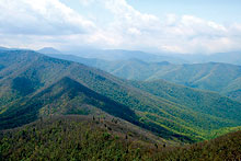
Fabled peak: The view from Cold Mountain. photos by Danny Bernstein
|
There are more than 30 peaks in Western North Carolina that are higher than Cold Mountain, but none more famous, thanks to Charles Frazier’s best-selling book and the subsequent movie. And while most people content themselves with viewing the mountain from the Blue Ridge Parkway (milepost 411.8), if you climb it, you’ll enjoy superb 180-degree views of the Shining Rock Wilderness.
When I first read Cold Mountain, I lived in New Jersey. At the time it was all I could do to find Raleigh and Charleston on a map, so I concentrated on the story. The protagonist, Inman, deserts the Confederate Army after being wounded at Petersburg and walks home to Cold Mountain; meanwhile Ada, his love, is left behind to make a life for herself in the mountains.
Upon moving to Asheville several years later, I learned that Cold Mountain was a real place and, what’s more, practically in our back yard. After climbing the mountain, I re-read the novel and underlined every place name I came across: Shining Rock, Mount Sterling, Cataloochee, Balsam Mountain, Tanawha, etc. The book could serve as a guide to hiking the mountains of North Carolina.
With that in mind I began, on foot and by car, to look for all the places mentioned in the novel. I scouted, bushwhacked and talked to many locals from all sides of Cold Mountain, including Ted Darryl Inman, the clan’s current patriarch.
I wrote a book about my treks and sent proposals to more than 50 regional publishers. I got mixed reactions: “Great idea but it won’t sell”; “Memoirs don’t do well”; “We don’t publish hiking guides”; “Cold Mountain is over.” But the Cold Mountain phenomenon clearly is not “over,” since Charles Frazier’s next novel will be published in October and a new edition of his first one is due out soon.
So I put my manuscript away and climbed Cold Mountain again. This time, I started writing a hiking guide, for which I had no trouble finding a suitable publisher.
The hike
The press describes the Cold Mountain climb as if it were a trek up Mount Everest instead of a day hike (9.4 miles round trip, with a 3,500 foot ascent). Since the hike is in a wilderness area, the trails are not blazed, but a new sign has been placed at the trailhead.
The hike starts on the northern end of the Art Loeb Trail, where you’ll travel from an elevation of 3,200 feet to 6,030 feet. Along the way you’ll see vegetation that is staggered throughout the seasons. In spring, flowers that are past their prime down below are waiting to bloom up top. In early autumn, the trees on top have already changed color while below, leaves are still green.
The trail starts out rocky and steep among rhododendron, mountain laurel, hemlock and oak. At 1.7 miles, cross Sorrel Creek, whose water cascades down toward Sorrel Creek Road. As you climb, you’ll cross several old roads, but keep to the left and keep going up. After 3.2 miles, you’ll reach Deep Gap at 5,010 feet. This large, flat area was once a grassy bald where cattle grazed in the summer months. Since then, hardwood trees have grown up. Several trails fan out from the gap in different directions.
Make a left on the Cold Mountain Trail, obvious but unmarked. Look to your right (due east) for a view of Mount Pisgah with its characteristic tower. Climb over some downed tree trunks. (Maintenance is more difficult here, because the wilderness designation means trail crews can’t use chain saws.) A spring on the right supplies water for the campsites farther up.
Where the trail makes a right turn, you’ll find several good campsites. Finally, you’ll reach the ridge on the summit with three south-facing, rocky outcrops to the right. The first view is just before you get to the mountaintop. Continue on the trail to a second rock outcrop for the best views.
The Narrows, a spine between Cold Mountain and Shining Rock, looks wild and seems to go on forever. If it’s not too windy, this is the place for lunch. With good binoculars and a little imagination, you can see some rock glittering at the end of The Narrows, which is what gives Shining Rock its name. The two peaks of Sam Knob are clear, and Mount Pisgah is all the way to the left. Dark balsam trees — the classic Christmas trees — dot the near landscape like ents (the walking trees in Tolkien’s The Lord of the Rings). From this vantage you can’t see any roads except for the faint cut of the Blue Ridge Parkway. You are gazing into the heart of a green wilderness crisscrossed with a multitude of ridges and spines. There is no graffiti, no initials carved on the rocks. Suffice it to say, the panorama is worth the effort it takes to get here.
Continue on the trail to the third view point at the official summit. As you turn onto the small, rocky outcropping (not very obvious from the trail), look for a survey marker on the ground. Congratulations! You’ve made it to the top of Cold Mountain.
The Inman chapel
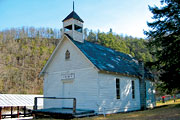
That old time religion: The Inman Chapel, where Cold Mountain author Charles Frazier’s grandparents are buried.
|
On your way back down, make sure you stop to see the Inman Chapel. On N.C. 215, pass the Lake Logan fire station and turn left on Friendly Place. Drive past a private residence and turn left at the Inman Chapel, a simple wood-frame church with a small, square belfry atop a gable roof. The chapel is usually closed, but you can wander through the cemetery, where many members of the Inman clan — as well as Charles Frazier’s grandparents — are buried.
[Danny Bernstein, a hike leader and outdoors writer, can be reached at danny@hikertohiker.org.]
Reaching the trailhead
From Asheville, take Interstate 40 west to exit 31 and follow N.C. 215 south past Canton. Turn left on S.R. 1129 (Little East Fork Road), where there is a sign to the Daniel Boone Boy Scout Camp. Once you enter the camp, stay to the left, continuing past the buildings. The road eventually becomes a Forest Service road; parking is available opposite the information board.
Before you comment
The comments section is here to provide a platform for civil dialogue on the issues we face together as a local community. Xpress is committed to offering this platform for all voices, but when the tone of the discussion gets nasty or strays off topic, we believe many people choose not to participate. Xpress editors are determined to moderate comments to ensure a constructive interchange is maintained. All comments judged not to be in keeping with the spirit of civil discourse will be removed and repeat violators will be banned. See here for our terms of service. Thank you for being part of this effort to promote respectful discussion.