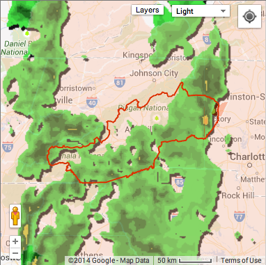
The tornado watch has been extended until 10 p.m. for 35 counties in North Carolina, including many counties in WNC (for full list, see below). A tornado warning was issued for Alexander, Burke, Caldwell and Catawba counties. The warning expired at 3 p.m.
A flash flood watch has also been issued, effective until 6 a.m., for counties in Western North Carolina and Northeast Georgia, including Avery, Buncombe, Burke Mountains, Caldwell Mountains, Eastern McDowell, Graham, Greater Burke, Greater Caldwell, Haywood, Henderson, Macon, Madison, McDowell Mountains, Mitchell, Northern Jackson, Southern Jackson, Swain, Transylvania and Yancey.
A tornado/flash flood watch means that the potential exists for the formation of a tornado and/or flash flood. “When a watch is issued, you should go about your normal activities,” reads a passage from the National Oceanic and Atmospheric Administration’s website. “But keep an eye to the sky and an ear to the National Weather Service’s weather radio or local radio and television stations for further updates and possible warnings.
“A tornado warning, on the other hand, means that a severe thunderstorm is occurring or is imminent based on doppler radar information. You should move indoors to a place of safety. Schools should think about delaying departure of buses, and should take quick action to delay outdoor sports activities, etc.”
From the National Weather Service:
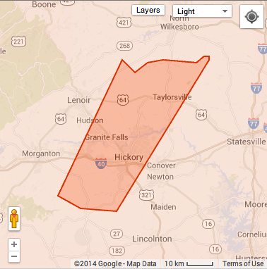
Tornado Warning: The National Weather Service in Greenville-spartanburg has issued a Tornado Warning for: Alexander County in the Piedmont of North Carolina. Southeastern Burke County in western North Carolina. Southeastern Caldwell County in western North Carolina. Western catawba county in the Piedmont of North Carolina.
Tornado warning in affect until 3 p.m. for Hickory area.
Until 3:00 pm EDT.
At 2:13 pm EDT, National Weather Service Doppler radar indicated a severe thunderstorm capable of producing a tornado. This storm was located near Icard, or 10 miles southwest of Hickory, and moving northeast at 35 mph.
This storm will impact locations near Icard, Mountain View, Connelly springs and Rutherford College. Longview, Hickory and Lake Rhodhiss. Granite Falls and St. Stephens. Lake Hickory and Bethlehem. Ellendale and Kings Creek.
Recommended actions:
A tornado is likely developing. Seek shelter in an interior room on the lowest level of a house or office building. Place as many floors and walls between you and the outside as possible.
Please Report damaging winds, hail, or flooding to the National Weather Service Greenville Spartanburg by calling toll free, (800) 267-8101, or by posting on our Facebook page, or tweet it using Hashtag Nwsgsp. Your message should describe the event and the specific location where it occurred.
Tornado Watch 548 is in effect until 10:00 pm EDT For the following locations NC.
If you are under a tornado warning, seek shelter immediately! Most injuries associated with high winds are from flying debris, so remember to protect your head.
If you are in a structure, go to a pre-designated shelter area such as a safe room, basement, storm cellar, or the lowest building level. If there is no basement, go to the center of an interior room on the lowest level (closet, interior hallway) away from corners, windows, doors, and outside walls.
If you are in a trailer or mobile home, get out immediately and go to the lowest floor of a sturdy, nearby building or a storm shelter.
If you are outside with no shelter, immediately get into a vehicle, buckle your seat belt and try to drive to the closest sturdy shelter. Do not get under an overpass or bridge. You are safer in a low, flat location. Watch out for flying debris. Flying debris from tornadoes causes most fatalities and injuries.
We share your inclination to get the whole story. For the past 25 years, Xpress has been committed to in-depth, balanced reporting about the greater Asheville area. We want everyone to have access to our stories. That’s a big part of why we've never charged for the paper or put up a paywall.
We’re pretty sure that you know journalism faces big challenges these days. Advertising no longer pays the whole cost. Media outlets around the country are asking their readers to chip in. Xpress needs help, too. We hope you’ll consider signing up to be a member of Xpress. For as little as $5 a month — the cost of a craft beer or kombucha — you can help keep local journalism strong. It only takes a moment.
About Hayley Benton
Current freelance journalist and artist. Former culture/entertainment reporter at the Asheville Citizen-Times and former news reporter at Mountain Xpress. Also a coffee drinker, bad photographer, teller of stupid jokes and maker-upper of words. I can be reached at hayleyebenton [at] gmail.com. Follow me @HayleyTweeet
The comments section is here to provide a platform for civil dialogue on the issues we face together as a local community. Xpress is committed to offering this platform for all voices, but when the tone of the discussion gets nasty or strays off topic, we believe many people choose not to participate. Xpress editors are determined to moderate comments to ensure a constructive interchange is maintained. All comments judged not to be in keeping with the spirit of civil discourse will be removed and repeat violators will be banned. See here for our terms of service. Thank you for being part of this effort to promote respectful discussion.


Before you comment
The comments section is here to provide a platform for civil dialogue on the issues we face together as a local community. Xpress is committed to offering this platform for all voices, but when the tone of the discussion gets nasty or strays off topic, we believe many people choose not to participate. Xpress editors are determined to moderate comments to ensure a constructive interchange is maintained. All comments judged not to be in keeping with the spirit of civil discourse will be removed and repeat violators will be banned. See here for our terms of service. Thank you for being part of this effort to promote respectful discussion.