

From the Institute for Climate Education at A-B Tech: It’s amazing how different each year can be as the ever-changing seasons unfold before our eyes. You may remember that the spring of 2012 was warm — very warm with average temperatures last March that were over 9 degrees above normal in Western North Carolina.* That warm spring resulted in trees, shrubs and flowers that were already greening up in late March and early April 2012.
This year has been significantly different, with temperatures in March and early April running well below normal. (We didn’t see above average temps until this weekend.) And as a result, the tree and shrub growth is well behind where it was this time last year.
A picture can always say so much more than statistics and figures, so take a look at the comparison below.
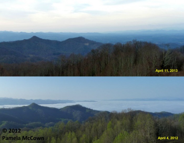
The top image was taken this morning and the one on the bottom was taken the first week of April 2012. You can see that the growth this year is behind schedule. (See the Fun Facts from April 4, 2012 here.)
This difference is not isolated to our region alone. It’s the same story across most of the Central and Eastern U.S., as you can see in the graphic below. The areas shaded in brown and yellow show where vegetation across a large part of the country is still relatively inactive compared to where it was on this date (April 11) of last year. Areas in green show increased active growth compared to last year.
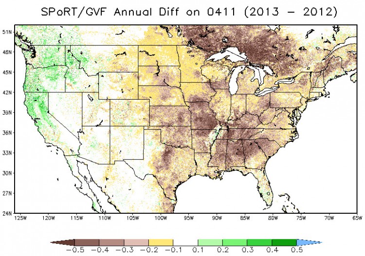
Image Credit: NASA Short-term Prediction Research and Transition Center (SPoRT)
Technically speaking, the graphic above shows the annual difference of the Green Vegetation Fraction (GVF), which represents photosynthetically active healthy vegetation — in simpler terms, it shows the status of plants and whether or not they are leafed out and growing compared to last year. The product is produced daily using data from the Moderate Resolution Imaging Spectroradiometer (MODIS) aboard the NASA Earth Observing System satellites and, other than providing us with a cool gee-wiz way to see the dynamic nature of our climate, is used in weather forecast models. (Yes, you’d be amazed at the level of detail that goes into creating more accurate weather forecasts!)
Thunderstorms to move through late Thursday
Keep in mind that we are expecting to see our first spring thunderstorm event late Thursday and into Friday as the large storm system that has been creeping its way across the U.S. this week moves eastward and brings a cold front through our region overnight. Scattered storms are developing to our southwest, and that activity will move into WNC as we head into this evening and overnight.
Stay weather aware and bookmark this website to keep an eye on the storms.
*State Climate Office of North Carolina April 2012 Newsletter
Before you comment
The comments section is here to provide a platform for civil dialogue on the issues we face together as a local community. Xpress is committed to offering this platform for all voices, but when the tone of the discussion gets nasty or strays off topic, we believe many people choose not to participate. Xpress editors are determined to moderate comments to ensure a constructive interchange is maintained. All comments judged not to be in keeping with the spirit of civil discourse will be removed and repeat violators will be banned. See here for our terms of service. Thank you for being part of this effort to promote respectful discussion.