


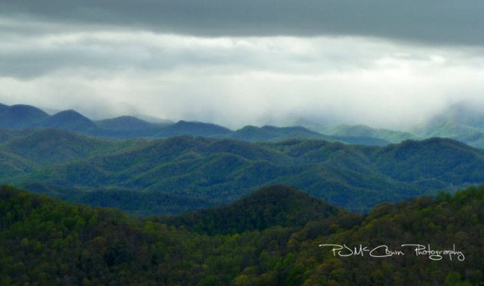
From the Institute for Climate Education at A-B Tech: After a wet April, it looks like the large-scale weather pattern will not shift much as we head into this first week of May. Thursday morning, May 2, brought light showers into the mountains — especially east of Asheville as you can see in the image below of the Black Mountains taken around 8 a.m. Thursday morning.
The abundant rainfall has helped to ensure a very green and lush spring, but some areas of Western North Carolina have seen way too much rain recently.
The rainfall total at Asheville Regional Airport of 5.88 inches for the month is 2.55” above normal for April. But that is nothing compared to the extensive rainfall that has been occurring to the west of the metro area. The image below shows the departure from normal rainfall across the state for the last 30 days. Notice that much of Buncombe and Henderson counties have seen more than 2 inches above-normal rain during April as depicted with the turquoise color. (There’s a legend to the right of the image.) But look to the west, where the dark blue and purple colors show widespread areas that have seen over 4” above normal rain just in the last 30 days. A weather spotter in Transylvania county reported 14.57 inches of rain for the month!
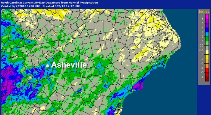
Image credit: NOAA’s National Weather Service Advanced Hydrologic Prediction Service
And, the coming weekend promises to bring more rain as a large weather system approaches from the west, producing a cloudy and cool weekend with an increasing chance of rain Saturday that will last into early next week. That system has already begun to influence our weather, as is evident in a cool time-lapse movie of the clouds across our region on Wednesday, May 1.
You’ll see the entire day unfold as you look south across the French Broad River Valley from a mountain top in Madison County. Looking toward Asheville, you’ll see the low clouds and fog early in the day then a dynamic shift in the clouds as the day goes on. Take note of the low clouds moving in one direction and the upper level clouds coming in from the west ahead of that next storm. You can even spot a fire in the valley and a bee bum that makes its mark of the camera lens. (Oh my!) Click here to start the video.
If you want to learn more about the camera and where it’s looking? Find out here.
Before you comment
The comments section is here to provide a platform for civil dialogue on the issues we face together as a local community. Xpress is committed to offering this platform for all voices, but when the tone of the discussion gets nasty or strays off topic, we believe many people choose not to participate. Xpress editors are determined to moderate comments to ensure a constructive interchange is maintained. All comments judged not to be in keeping with the spirit of civil discourse will be removed and repeat violators will be banned. See here for our terms of service. Thank you for being part of this effort to promote respectful discussion.