


From the Institute for Climate Education at A-B Tech: While millions in the Northeast are still trying to recover from the impacts of Hurricane Sandy, the region is bracing for yet another storm — the infamous nor’easter.
The image below was taken by NOAA’s GOES-13 satellite at 9:15 a.m. on Wednesday, Nov 7, showing the center of low pressure (also called a cyclone) off the Mid-Atlantic coast. NOAA forecasts the storm to continue to strengthen as it moves north on Wednesday, bringing rain, snow, and/or a mixture of precipitation to areas across the northern Mid-Atlantic and Northeast, as well as wind gusts as high as 60 mph along the coast.* (Image credit: NOAA)
A nor’easter (or northeaster)** is an intense extratropical cyclone that tracks along the East Coast of the U.S. These storms are most common in the colder months, from October through April, and can be thought of, in some respects, as the cold season’s equivalent to a hurricane. A nor’easter is a large and complex storm that rotates around a center with winds that can reach hurricane strength, creating storm surge, coastal flooding, property damage and large areas of intense precipitation. However, that is where the similarities between a hurricane and a nor’easter end.
While they may look similar when viewed from above by satellites, a hurricane (a tropical cyclone) and a nor’easter (an extratropical cyclone) are driven by different atmospheric conditions.
A hurricane is a warm-core tropical system — meaning it derives its energy from the warm waters of the Earth’s tropical and subtropical oceans. In general, the surface temperature of an ocean must be at 80 degrees F or above to support the development of tropical systems like hurricanes. Water temperatures this warm are typically found during the warm months in the Earth’s tropical climate regions (within 23.5° latitude of the Equator) and in areas of the subtropics (below 40° latitude) where ocean currents move warm waters toward the poles. The Gulf Stream is such a current. It moves warm water out of the Gulf of Mexico, around Florida and up the East Coast of the U.S. The Gulf Stream is one reason why we have hurricanes that make landfall along the East Coast of the U.S. but not the West Coast, where the water of the Pacific Ocean is significantly cooler.
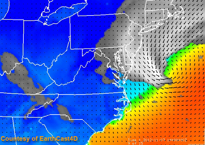
A nor’easter is a cold-core extratropical system — meaning that it derives its energy from the interaction of warm and cold air masses. The image below is generated by a high resolution forecast model valid for the same time as the satellite image above, and it shows the temperature differences that are feeding the developing nor’easter. You can see the counterclockwise flow around the center of the storm as indicated by the black wind arrows. The bright colors off the coast indicate warm sea surface temperatures with the oranges showing the warm waters of the Gulf Stream.
Notice the blues that extend over the land and into the Chesapeake Bay and Atlantic Ocean closest to shore? Those blues represent the cold air and cold sea surface temperatures in place following the passage of the cold front that helped to power-up Hurricane Sandy into a super storm last week. It is the interaction of these strong temperature differences that is helping to develop the nor’easter.
The impacts of a nor’easter seldom affect those of us in Western North Carolina, but when they do — they make history. Remember the Blizzard of 1993 when Mount Mitchell recorded 50 inches of snow? Also known as the “Storm of the Century” — that storm was a nor’easter that developed over the Gulf of Mexico and then crossed the Southeast and tracked up the East Coast.
The storm currently in the Atlantic is not expected to have a negative impact on Western North Carolina. In fact, our weather is expected to improve into the weekend. However, it looks like we will have another significant system impact our weather early next week.
The Long Range Winter Forecast Seminar is tonight at 6 p.m. at Ferguson Auditorium on the A-B Tech campus. It is free and open to everyone. Are these early-season systems a sign of a long and harsh winter season? Meteorologist Tom Ross will present the long range winter weather outlook.
for Western North Carolina.
* NOAA’s Environmental Visualization Laboratory and NOAA’s National Weather Service Hydrometeorological Prediction Center
** http://en.wikipedia.org/wiki/Nor%27easter
Before you comment
The comments section is here to provide a platform for civil dialogue on the issues we face together as a local community. Xpress is committed to offering this platform for all voices, but when the tone of the discussion gets nasty or strays off topic, we believe many people choose not to participate. Xpress editors are determined to moderate comments to ensure a constructive interchange is maintained. All comments judged not to be in keeping with the spirit of civil discourse will be removed and repeat violators will be banned. See here for our terms of service. Thank you for being part of this effort to promote respectful discussion.