

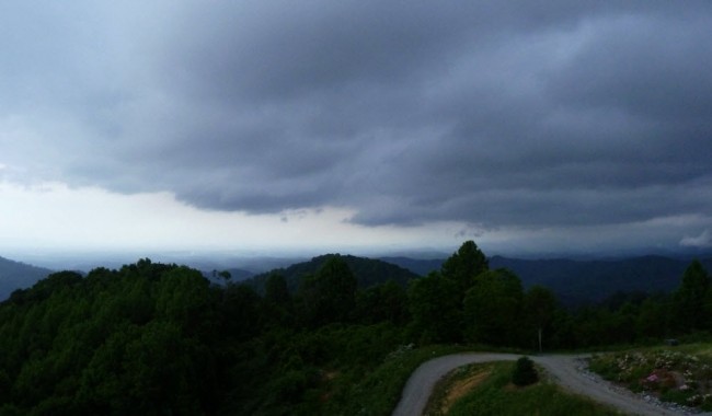
A line of showers and storms moved into Western North Carolina Wednesday evening, June 5, just as the sun was setting. I snapped the image below just as the menacing clouds were topping the ridgeline where I live in Madison County and were on their way to deliver rain to Mars Hill, Weaverville and Asheville in the valley below.
The rain added anything from a quarter to more than a half inch to rain gauges in and around the French Broad River Valley, with higher totals in the elevated terrain west and east of Asheville.
And … more rain is on the way, thanks to Tropical Storm Andrea.
What? Tropical systems here in the mountains??
As you’re probably aware, June 1 was the official start of the hurricane season in the Atlantic Basin. Although we are about as far inland as you can be in North Carolina, we are still susceptible to the impacts of tropical systems in the mountains. That is especially true with storms that make landfall along the Gulf Coast. (Remember the flooding rains associated with Frances, Ivan and Jeanne in 2004?)
Tropical Storm Andrea intensified late Wednesday from a disorganized mass of bubbling thunderstorms to a more defined system with a circulation to it. The image below is from NASA’s Terra Satellite at just after 12:30 p.m. on Wednesday, showing the mass of storms in the Gulf of Mexico.
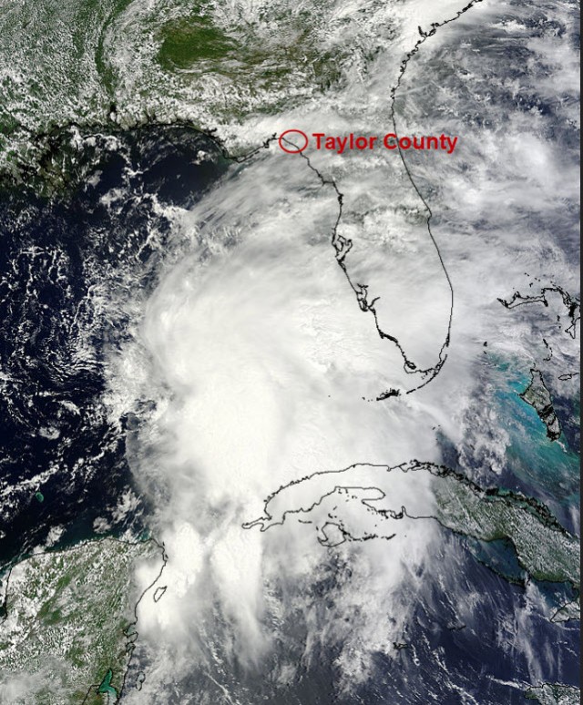
Image credit: NASA’s Terra satellite (with annotation by Pamela McCown)
On Thursday, June 6, Tropical Storm Andrea turned northeastward and began to pick up speed as it started to interact with another area of low pressure over Tennessee. The system was expected to make landfall in Taylor County Florida, where the coastline makes a big bend toward the southeast. (I marked its general location on the image above.) Air Force Reconnaissance was scheduled to fly into the system Thursday afternoon and provide an update on its exact location and any intensification.
If there is any good news with a tropical storm like this, it is that the system is expected to move quickly across the Southeast and then up the coast. That is good news, because the biggest threat from a system like this is the heavy tropical rainfall that it brings. The faster it moves, the less rain it can drop.
So expect more rain here in Western North Carolina and across much of the Eastern U.S as a result of this system. The latest rainfall forecast from NOAA looks like this:
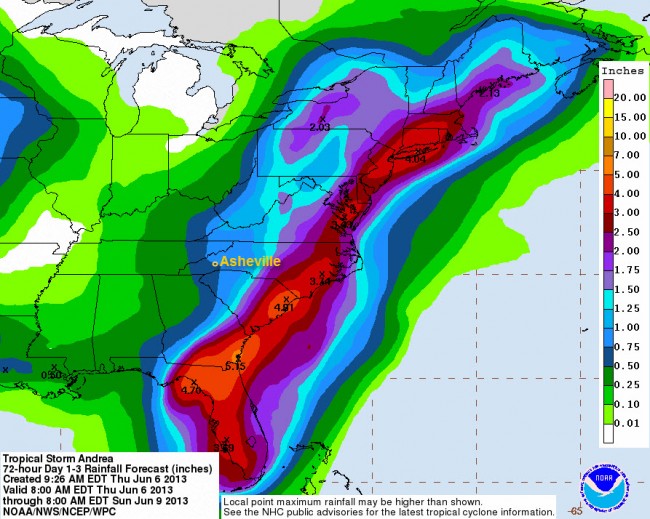
Image: NOAA’s National Weather Service Weather Prediction Center
Keep in mind that the forecast above is for the overall precipitation pattern from the storm and that the heaviest rain is expected to our south and east. However, locally heavy rainfall is possible in our area, especially in the higher elevations and along the escarpment thanks to the abundant tropical moisture that will be moving in tonight and the way that it interacts with our unique landscape. That means that the usual risks of flash flooding and landslides does exist in areas that receive heavy rain.
North Carolina’s long history with the tropics.
You can imagine that our state has had quite a few run-ins with these monster storms, and records for tropical systems and their impact on North Carolina go back to 1851. In that period of time, 94 tropical systems are known to have affected the state: 45 of them making direct landfall along the N.C. coast and at least 49 of them affecting the state but not making landfall here. (2012’s Sandy is not included in that list – but perhaps it should be.)
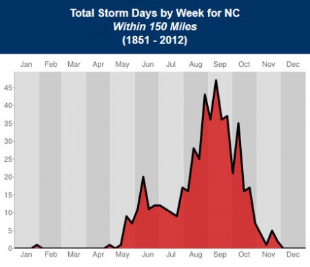
Graph: State Climate Office of North Carolina
The peak of the hurricane season is in mid-September, but there is actually another earlier peak in the storms that affect our state. As you can see in the graph above, the state sees an uptick in tropical activity in early June, as well.
If you want to learn more about N.C. and its history with tropical systems, the State Climate Office has some very interesting information here.
Before you comment
The comments section is here to provide a platform for civil dialogue on the issues we face together as a local community. Xpress is committed to offering this platform for all voices, but when the tone of the discussion gets nasty or strays off topic, we believe many people choose not to participate. Xpress editors are determined to moderate comments to ensure a constructive interchange is maintained. All comments judged not to be in keeping with the spirit of civil discourse will be removed and repeat violators will be banned. See here for our terms of service. Thank you for being part of this effort to promote respectful discussion.