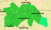
The National Weather Service has issued a a flash flood watch for several counties in the Asheville area until midnight tonight, warning that widespread showers, heavy rains and thunderstorms could pose a danger.
The warning is for Henderson, Macon, Jackson, Transylvania and part of Polk counties as well as parts of South Carolina and North Georgia. Thunderstorms and heavy rains are also forecast for Asheville today and throughout the week.
Full announcement from the National Weather Service below.
— David Forbes, senior reporter
…VERY HEAVY RAINFALL EXPECTED TODAY AND TONIGHT…
.AN UPPER LEVEL DISTURBANCE WILL MOVE EASTWARD TOWARDS THE REGION
TODAY AND TONIGHT WITH WIDESPREAD SHOWERS AND THUNDERSTORMS
CONTINUOUSLY DEVELOPING ACROSS THE WESTERN CAROLINAS AND NORTHEAST
GEORGIA. THIS COMBINED WITH PERSISTENT UPSLOPE FLOW WILL CAUSE
VERY HEAVY RAIN TO FALL ACROSS THE AREA…ESPECIALLY IN LOCATIONS
ALONG AND NEAR THE SOUTH FACING ESCARPMENT.
…FLASH FLOOD WATCH IN EFFECT THROUGH TUESDAY MORNING…
THE NATIONAL WEATHER SERVICE IN GREENVILLE-SPARTANBURG HAS ISSUED
A
* FLASH FLOOD WATCH FOR PORTIONS OF NORTHEAST GEORGIA…WESTERN
NORTH CAROLINA AND UPSTATE SOUTH CAROLINA…INCLUDING THE
FOLLOWING AREAS…IN NORTHEAST GEORGIA…HABERSHAM…RABUN AND
STEPHENS. IN WESTERN NORTH CAROLINA…EASTERN POLK…
HENDERSON…MACON…NORTHERN JACKSON…POLK MOUNTAINS…
SOUTHERN JACKSON AND TRANSYLVANIA. IN UPSTATE SOUTH CAROLINA…
GREATER GREENVILLE…GREATER OCONEE…GREATER PICKENS…
GREENVILLE MOUNTAINS…OCONEE MOUNTAINS…PICKENS MOUNTAINS
AND SPARTANBURG.
* THROUGH TUESDAY MORNING
* WIDESPREAD SHOWERS AND THUNDERSTORMS WILL CONTINUE TO DEVELOP
THROUGH TODAY AND INTO THE OVERNIGHT HOURS CAUSING VERY HEAVY
RAIN TO FALL. THOUGH THESE STORMS ARE NOT EXPECTED TO MOVE
PARTICULARLY SLOW…TRAINING OF THUNDERSTORMS ACROSS THE SAME
AREAS THROUGHOUT THE DAY COULD CAUSE EXCESSIVE AMOUNTS OF RAIN
TO FALL.
* HEAVY RAIN PRODUCED BY WIDESPREAD SHOWERS AND THUNDERSTORMS
COULD CAUSE RAPID RISES OF WATER LEVELS IN AREA CREEKS AND
STREAMS. FLASH FLOODING WILL BE POSSIBLE…ESPECIALLY AREAS THAT
EXPERIENCE RAPID RUNOFF FROM PERSISTENT AND TRAINING
THUNDERSTORMS. ALSO…AREAS WITH STEEP TERRAIN WILL BE
ESPECIALLY SUSCEPTIBLE TO FLASH FLOODING.


Before you comment
The comments section is here to provide a platform for civil dialogue on the issues we face together as a local community. Xpress is committed to offering this platform for all voices, but when the tone of the discussion gets nasty or strays off topic, we believe many people choose not to participate. Xpress editors are determined to moderate comments to ensure a constructive interchange is maintained. All comments judged not to be in keeping with the spirit of civil discourse will be removed and repeat violators will be banned. See here for our terms of service. Thank you for being part of this effort to promote respectful discussion.