


Will you allow today’s rivers of rain to turn your holiday cheer to drear? We hope not, because the forecast is for wet, wet and more wet all day Christmas Eve and into Dec. 25. At 10:30 a.m. the National Weather Service issued a flash flood watch, advising that some locations in the southern North Carolina mountains have received as much as four inches of rain over the past 24 hours.
Moisture from the Gulf of Mexico is driving the deluge, and additional moisture will continue to be pulled northward from the Gulf across the western North Carolina area throughout the day in front of a slow-moving cold front west of the Appalachians. The thunderstorms that provided an early-morning wake up call to many could continue throughout the day.
The flash flood watch will be in effect until 7 p.m., but the NWS warns that it may be extended past that time if significant rainfall continues. Flooding on creeks, streams and some rivers is expected, and landslides or mudslides are possible. Additional rainfall amounts of 1/2 inch or more per hour are possible during periods of heavy rainfall.
The day’s high will be near 70, with a south wind of five to nine miles per hour.
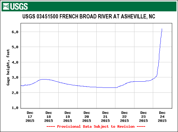
According to the U.S. Geological Survey gauge on the French Broad River in Asheville, the river is running at just over six feet, with a discharge volume of over 10,000 cubic feet per second. The average height of the river at this location is around two and a half feet at this time of year, while flood stage is nine and a half feet.
The chance of precipitation falls to 70% during the evening hours, with Christmas Day expected to be marked by showers and possible thunderstorms. New rainfall amounts of less than 1/4 inch are forecast, except that higher amounts are possible during thunderstorms. Overnight, the low will be around 60.
Saturday should see some clearing, with a lingering slight chance of showers and thunderstorms. The forecast is for a partly sunny day with a high near 70. The low Saturday night will be around 58.
Before you comment
The comments section is here to provide a platform for civil dialogue on the issues we face together as a local community. Xpress is committed to offering this platform for all voices, but when the tone of the discussion gets nasty or strays off topic, we believe many people choose not to participate. Xpress editors are determined to moderate comments to ensure a constructive interchange is maintained. All comments judged not to be in keeping with the spirit of civil discourse will be removed and repeat violators will be banned. See here for our terms of service. Thank you for being part of this effort to promote respectful discussion.