


Try walking almost anywhere in the River Arts District and its infrastructure deficiencies will become readily apparent.
Pedestrians along Riverside Drive and Lyman Street must traverse ditches and tall grass or take their chances sharing the narrow roadways with the cars, trucks, buses and cyclists that sometimes zip by within an arm’s length. On Roberts Street, crowds of curious onlookers heading toward the galleries can be seen peering anxiously from between parked cars, waiting to cross the street to reach crumbling sidewalks that peter out unexpectedly.
But changes are on the way: Asheville’s rustic, arts-and-industry-dominated River Arts District is on the brink of a major transformation. From road realignment, sidewalk construction and expanded bike lanes to an ambitious network of greenways with the RAD as its central hub, substantial changes will be taking place over the next few years that will improve the way residents and visitors to the city access, explore and inhabit the area.
Using federal, state and local grants, combined with funds from Asheville’s own coffers and debt financing, the city and its partners say they hope improved infrastructure will prepare the RAD for the waves of commercial and recreational investment that have already begun sweeping across the area, while trying to ensure the RAD’s current residents aren’t lost in the dust of construction.
RAD redux
“The RAD has been evolving for quite a while now, and it’s had this burst of popularity in the last few years,” says Mary Weber, chair of the volunteer-driven Asheville Greenway Committee. “The infrastructure is so far behind the use there. It’s long overdue, and it’s just not very safe, walking down some of those roads.”
Signs of the upgrades coming to the RAD over the next few years are beginning to show in several areas of the district: Along Lyman Street, stakes with colored ties mark the proposed utility realignment, while work crews remove trees near the river in anticipation next year’s construction along the narrow corridor.
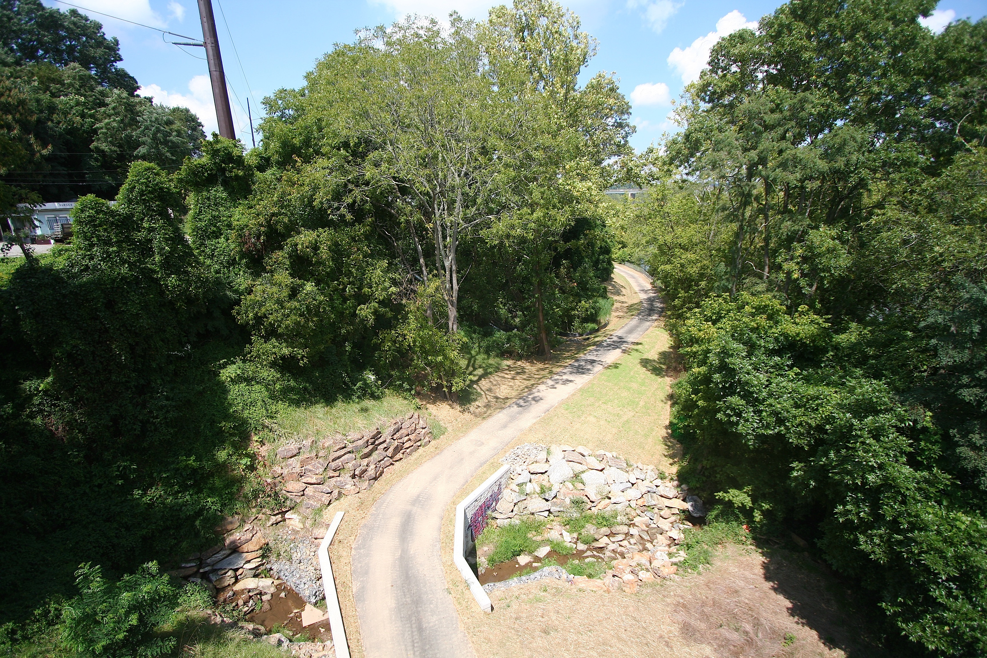
Across the river, on Craven Street, near New Belgium’s facility, wide sidewalks lead past the brewery, with scores of designated on-street parking spots lining the road. From the RiverLink Bridge, one can peer down at New Belgium’s nearly completed portion of what will become the French Broad River Greenway West, which will eventually link to existing greenways in West Asheville and beyond.
“We’ve recognized that the RAD is an area ripe for redevelopment,” says Asheville Design Center’s Chris Joyell, whose nonprofit organization helped draft the 2014 Riverside Drive Development Plan. “As the area transforms from industrial hub to gritty artists’ district to a visitor destination, the infrastructure has to respond.”
Transportation by any other name
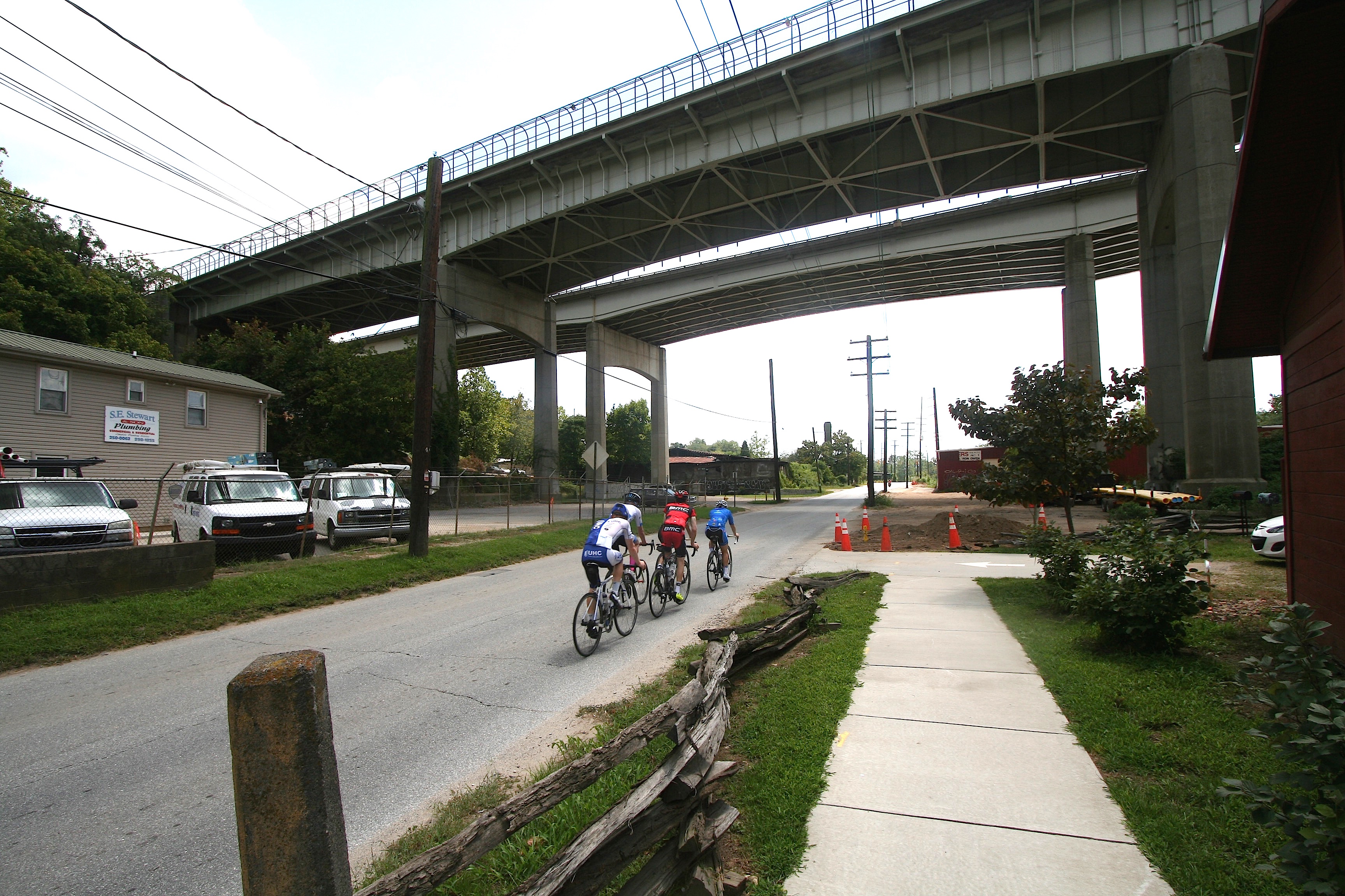
Drivers and pedestrians traveling between Amboy Road and Hill Street along the Lyman-Riverside Drive corridor are familiar with the cramped road conditions, the sharp blind curve in front of the 12 Bones property and the limited clearance beneath the old, double-arched Norfolk Southern Railroad Bridge.
Under the River Arts District Transportation Improvement Project, or RADTIP, which encompasses a 2.2-mile stretch of the 17-mile redevelopment area identified in the Wilma Dykeman RiverWay plan, the intersection of Riverside and Lyman will cut through the 12 Bones property, eliminating the sharp curve in favor of a traffic circle. Plans include bike lanes on both sides of the roadway, sidewalks for pedestrians, some on-street parking and a greenway on the east side of the river.
“Riverside Drive and Lyman Street are main thoroughfares for a lot of different people, not just the folks coming to visit the artists, but the people going to A-B Tech and Mission [Hospital],” notes Stephanie Monson, Asheville city planner and staff liaison for the Asheville Area Riverfront Redevelopment Commission.
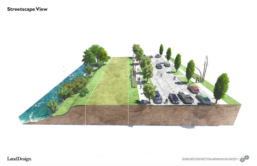
In addition, a traffic circle at the Five Points intersection, near The Soapy Dog, will facilitate smoother traffic flow, and the intersection of Craven Street and Riverside Drive will be reconfigured to accommodate truck traffic. The Livingston Street Complete Streets project will add sidewalks and pedestrian crossings to a portion of Depot Street. At the northern end of the RAD, the Norfolk Southern Railroad Bridge will be redesigned to allow for more vertical and horizontal clearance for traffic on Riverside Drive, and railroad crossings at Craven and Lyman streets will be improved, according to the city of Asheville’s website.
These projects will help tie together an area that historically has lacked concrete definition and boundaries, says Don Kostelec, a local transportation planner and consultant. “I always felt that, for being called a district, it never really had that cohesive feel,” he notes. “This type of major public infrastructure investment kind of puts it all out there in front at one time, instead of it kind of coming along piecemeal.”
The city has also begun exploring a potential shuttle program that could eventually include service between the RAD, downtown and West Asheville. [See “Asheville residents gather to provide feedback on downtown shuttle proposal,” Aug. 18, 2016, Xpress]
We really get around
“More and more people are wanting to live in cities and not rely on a car,” says Weber. “Making a city safe and walkable is a huge part of livability. I think this project is going to be a game-changer.”
By expanding and installing greenways, bicycle lanes and sidewalks along popular corridors in the RAD, the city can cut down on congestion while encouraging the use of environmentally friendlier, cost-efficient transportation, notes Mike Sule, a representative from Asheville on Bikes.
“It doesn’t pit one mode [of transportation] against another mode,” he says. “This is going to be the first application of a cycle track and a greenway, your regular travel lane and a sidewalk, all working together comprehensively.”
The city’s emphasis on multimodal transportation meets a need that Asheville residents have publicly expressed, says Greenway Committee member Rich Lee, citing this year’s “Best of WNC” reader-poll rankings in which sidewalks, greenways and bike lanes topped the category “Project You’d Like to See Local Government Do” [Aug. 10, 2016, Xpress].
“If you look at the largest area employers, you’ve got Asheville City School district, you’ve got Mission Hospital System, A-B Tech and Biltmore Estate at the end of Amboy and Meadow Road down there. Almost all of the largest employers in Asheville and Buncombe County are along or at one end or the other of this road from Riverside Drive down to Meadow Road and Biltmore Avenue,” Lee notes. “Ideally, what we would have is an easy way for people who didn’t want to sit in traffic to make it from their homes to these places of employment.”
The project could also offer benefits to the local economy, notes Kostelec. “A lot of the new economic and jobs creation research is really showing that [this] type of project generates more jobs per million dollars than widening Interstate 26 or another widening project,” he says. “It meets sustainability goals for the city, [and] I think it’s a good springboard for a lot of other things.”
Going green
In addition the RADTIP projects, the expansion of Asheville’s greenway system into the RAD represents a turning point in transportation alternatives for the city, says Weber. “You can’t really build a whole lot because of floodplains, so it really makes sense for greenways to go there.”
The French Broad River greenways on the east and west banks of the river, for example, will offer connections to the existing greenway at the French Broad River Park in West Asheville, other greenway systems outside the RAD and New Belgium.
“Once the French Broad West Greenway is done, there’s going to be five contiguous miles of greenway from New Belgium to Hominy Creek, where you’re not crossing nearly any roads,” Weber points out. “Having greenways in the RAD, in addition to the sidewalks and bike lanes, provides lots of space for people to move around.”
Where designers and planners are not able to continue greenways due to existing obstacles or a lack of rights of way, plans call for greenway connectors — large sidewalks with signage directing greenway users from one trailhead to another — to guide users along the street.

Greenways also offer a chance to highlight residents’ passions and interests, Lee says. “Each one will have a really neat theme that will reflect a part of Asheville life or the area it’s built in.” The French Broad West Greenway, for example, will become an “edible mile,” he notes, with the Asheville-Buncombe Food Policy Council and other groups planning to grow demonstration gardens as well as fruit bushes and trees.
East of the river, the Clingman Forest Greenway will lead from the RAD to the outskirts of downtown, crossing through wooded areas behind Asheville Middle School and taking users past native plants, ravines and even into the treetops via elevated boardwalks.
The Town Branch Greenway, meanwhile, will thread its way through the booming South Slope neighborhood, connecting the River Arts District to the Beaucatcher Greenway. Along the way, signage and exhibits will highlight the South Slope’s heritage as a vibrant African-American community during the days of segregation and the civil rights movement.
Greenways can serve as a sort of “great equalizer” for residents of different backgrounds, Weber adds. “If you go to the greenway at Carrier Park on the weekends, it’s packed with people [of] every kind … every age, race, shape and ability.”
The addition of the Clingman Forest and Town Branch greenways will also offer cyclists and pedestrians an alternative to the relatively steep grades heading toward downtown and the Southside neighborhood, Lee notes. “The [Clingman Forest Greenway] will have less than 5 percent grade along its entire route,” he reports. “That means my kids could make it up on their training wheels, and I could easily make it up in a suit without breaking a sweat.”
According to Lucy Crown, Asheville’s greenway coordinator, the city moved its greenway program from the Parks Department to the Transportation Department four years ago specifically because of the growing recognition of greenways’ potential for multimodal transit.
But with limited space available in an urban, mountainous environment, finding a suitable course for greenways, sidewalks and other infrastructure expansions has been a challenge, Crown notes. “The DOT has very strict guidelines on what they expect us to do around their infrastructure: 25 feet from transmission lines, guidelines, poles — it’s dizzying.”
And with land in high demand in and around the RAD, and construction costs rising, time is of the essence, says Lee, adding that projects in the RAD must also compete with other infrastructure priorities in the city for limited funds.
“Every year when the budget is written, there’s the question: Should we put money into greenways or should we add a bus line? It’s not an infinite pool of money,” he notes. “We can’t say we’re going to put a hold on building greenways or sidewalks until every road in Asheville’s repaved. I think the city has done fairly well at balancing out priorities.”
Construction concerns
With so many construction projects happening simultaneously around a relatively small area, delays and inconveniences are to be expected, which has some business owners and artists in the RAD worried that they might be swept away amid the changes happening around their neighborhood.
Matt Tommey, an artist with studio space at Riverview Station, says that although construction is just beginning, he’s already noticed traffic jams, delays and frustration among both artists and customers, though his own business has not yet been negatively impacted.
Other stakeholders have been more frank in expressing their concerns. “As a business owner and property owner, yeah, I want bike lanes in front of my place. I want sidewalks, trees, benches, but I want to survive to be able to see that,” says Derek Dominy, owner of the Cotton Mill Studios on Riverside Drive.
Dominy has reservations concerning the city’s proposed easement on a portion of his land. The easement is related to the Riverside Drive realignment near 12 Bones, and he says it would give construction crews the right to store dirt and alter a front portion of his property as they deem necessary. “Coming from New York, I’ve seen guys put a cone in the wrong place and decimate a small business,” he adds.
To assuage concerns that visitors will steer clear of the RAD for the duration of the projects, Monson says the city is working hard to get the message out to the public that the RAD will be open for business during construction. “We’ve done radio spots on iHeart Radio and Asheville FM. We’ve also gone on air with WLOS, where we make sure we tell people that the RAD businesses are open.”
In addition, the city has implemented an information initiative designed to keep consistent lines of communication open between officials and stakeholders. “The first phase is we give all of the businesses and artists in the district a who-to-call card, so they know if they have questions, they can get them answered,” Monson explains. “Also, we’re working to create a rack card that goes up at the Convention & Visitors Bureau and other visitor locations, to address the concern artists have about out-of-town visitors staying away.”
Eminent debate
Other property owners in the RAD have balked at the city’s land acquisitions through easement agreements and eminent domain, a controversial practice that has drawn national debate in this year’s election cycle. According to a June 17, 2016 Asheville Citizen-Times report, 50 properties will be affected by RADTIP, 38 of which belong to private owners not affiliated with a railroad company.
“I have three loading docks in the front of my building and I’ve already been told by the city that they will be taking one of [them],” says Annette Pace, co-owner of the Asheville Waste Paper Co., which has been in business on Lyman Street since 1941.
In addition, Pace says that the city has acquired another property she owned at the north end of Smith Bridge near New Belgium. “I feel they are catering to New Belgium,” she says. “I’ve been here a lot longer than New Belgium or any of the artists and I try to emphasize that with anyone I talk with.”
City Councilwoman Gwen Wisler admits that New Belgium’s arrival in the area “was probably a big catalyst to spur the city on to putting all this investment in that area,” but she contends that the infrastructure plans go far beyond serving one particular business. “I assure you bike routes and sidewalks have little or nothing to do with New Belgium.”
Monson, meanwhile, says the city has established consistent communication with affected property owners to the best of its ability, and city staff members are working to accommodate everyone’s needs. “We’re pretty heavily invested in this group and trying to make sure it stays vibrant. We’ve met with the River Arts District Business Association and the River Arts District Artists group and individual property owners and even [non-RAD] people like A-B Tech to talk about the impacts on organizations.”
Other business owners concur that the city has done its due diligence in informing RAD stakeholders of what’s going on. And they are enthusiastic about the planned improvements.
Darren Green, owner of the Old Wood Co. building on Riverside Drive, equates the upcoming construction projects to renovating a house: “You kind of have to tear it apart first to put it back together,” he says. “What they’re planning on doing across from my shop on the green space — playgrounds for kids, a lot of cool stuff — I have three children, so I’m excited that they’ll be able to come down here, ride [bikes] around and kind of explore the district safely.”
Moving forward
While the Craven Street improvement project was largely completed last fall, major work on RADTIP and the greenways is set to begin next spring and will continue until 2020, with exception of the greenway connectors, which are slated to begin in 2019.
“So much neat stuff is in the works, and by 2019, it’ll just be a part of the fabric of living in Asheville,” Lee says. “You’ll be able to take the greenway down to Biltmore Village or wherever it goes.”
Following the completion of the RADTIP and the greenways, the city will begin implementation of secondary infrastructure development, as outlined in the Riverside Drive Development Plan, according to Asheville Design Center’s Joyell.

While he acknowledges that businesses and artists working in the RAD will experience inevitable challenges due to construction, he asserts that the end goal of the improvements being made in the RAD will ultimately enhance visitors’ and locals’ access to and experience of the area.
“That’s the challenge: How do you get beer trucks, tourists’ rental cars and residents moving through the area in a way that allows for positive growth in the district while affording as many transportation options as possible?” Joyell says. “I think the city has given this a lot of thought, and the RADTIP is their solution.”
Making the RAD a hub and example for future development efforts, says Weber, will provide benefits beyond the district. “Some people might say we’re just putting everything by the river,” the Greenway Committee chair acknowledges, “but we want to always be looking at the bigger picture and what we should be doing next. How do we serve other neighborhoods as well and try to connect everything?”
Last month, as pedestrians and cyclists traversed Craven Street on their way to New Belgium’s 25th anniversary party, a safe distance away from traffic, and riders waited for the bus along the wide sidewalks that ring the traffic circle where Haywood Rd. meets Roberts Street — an onlooker could catch a glimpse of what the city hopes the RAD’s infrastructure will become.
Before you comment
The comments section is here to provide a platform for civil dialogue on the issues we face together as a local community. Xpress is committed to offering this platform for all voices, but when the tone of the discussion gets nasty or strays off topic, we believe many people choose not to participate. Xpress editors are determined to moderate comments to ensure a constructive interchange is maintained. All comments judged not to be in keeping with the spirit of civil discourse will be removed and repeat violators will be banned. See here for our terms of service. Thank you for being part of this effort to promote respectful discussion.