


Many of us woke up Thursday morning to widespread fog across the French Broad River Valley, thanks to rains overnight that caused the layer of air at ground-level to become saturated – producing a cloud on the ground – or fog. Big changes are on the way with a strong cold front bringing an end to the mild weather on Friday.
Tag: weather
Showing 85-105 of 109 results
Climate data and more: Locus Technologies and UNCA’s NEMAC announce alliance

Locus and UNCA’s National Environmental Modeling and Analysis Center signed a letter of cooperation to establish a working relationship that will leverage both organizations’ resources in applied research, web development activities, cloud computing, and science delivery collaborations.
Where is winter? Look to the polar vortex
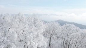
Snowflakes were flying earlier this week, as Valentine’s Day started off white at the higher elevations.
Snowflakes were flying earlier this week, as Valentine’s Day started off white at the higher elevations. This image of Max Patch in western Madison County shows the short-lived snow. So – what has happened to this winter? Why has it been so different than the last two years?

A cold, snowy day in Asheville: Dispatches from the Twitterverse
It’s a frigid, snowy day in Asheville, and the Twitterverse is alive with weather related information, from road conditions to cancellations and more. Photo by Zen Sutherland.
W is for water – not winter (apparently) in WNC
As we head into February, Western North Carolina continues to see plentiful rain as a steady stream of weather systems spread rainfall across the southern plains and into our area.

Our planet – A unique view of a truly unique place!

From the first full image of our planet shot by Apollo astronauts to the latest full disk image produced by NASA’s Suomi NPP satellite — we continue to marvel at the beauty of our unique planet as we gather critical data about its weather and climate.
Satellite image shows snow, clear skies for this eve’s orbit of the International Space Station
The above image was taken today, Jan. 5, at about 11 a.m. by the Terra satellite, part of NASA’s Earth Observing System. It shows a bit of snow in the high elevations outside of town, and clear skies for viewing the International Space Station, which will be visible over the region at 6:33 p.m.
Live Twitter updates on the WNC snow
Winter’s here as temperatures have dropped and snow is falling over the Asheville area. Follow live Twitter updates on the situation here.

Tomorrow’s solstice marks the first day of winter
The solstice occurs in Asheville at 12:30 a.m. tomorrow morning, Dec. 22, marking the beginning of winter. At that moment, the Earth’s axis will tilt the Northern Hemisphere at its largest angle away from the sun, according to Pamela McCown, coordinator at the A-B Tech Institute for Climate Education.

Green Scene: The walls fall
With asbestos abatement completed, a Buncombe County contractor began demolishing the former CTS of Asheville plant in south Asheville earlier this month. But while neighbors of the derelict structure have applauded the move as a long-overdue first step in cleaning up the contaminated site, resident Tate MacQueen, who’s played a key role in efforts to […]
NOAA meteorologist offers seasonal forecast for WNC winter
A winter weather advisory has been issued for the Western North Carolina mountains today, Dec. 7, beginning at 4 p.m. Last night, NOAA meteorologist Tom Ross presented a look at the long-range winter forecast for WNC: Ashevillians may enjoy (or complain about) plenty of snow again this winter.
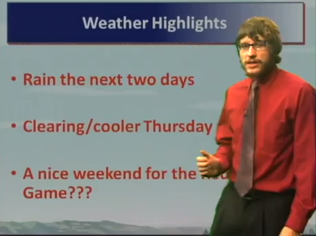
What’s it take to be a TV weatherman (or woman)? UNCA videos tomorrow’s TV prognosticators
Nine up-and-coming weathercasters, demonstrating their skills learned in UNCA’s Department of Atmospheric Sciences 328 Broadcast Meteorology class.
Asheville-based National Climate Data Center turns 60
_thumb.jpg) Weather Channel junkies, you are not alone. People have been obsessed with weather — and recording weather observations — for quite some time. Retro outfits and mod hairdos are no longer on view, but the Asheville-based National Climate Data Center celebrated its 60th birthday last week, and the center wants folks to know about the fascinating weather and climate information it has collected over the years.
Weather Channel junkies, you are not alone. People have been obsessed with weather — and recording weather observations — for quite some time. Retro outfits and mod hairdos are no longer on view, but the Asheville-based National Climate Data Center celebrated its 60th birthday last week, and the center wants folks to know about the fascinating weather and climate information it has collected over the years.
Weather Report: Near record-high temperatures today
The sweltering weekend heat is only going to get worse today, as temperatures in Asheville are expected to hit 91 degrees, just shy of the 92 degree record set back in 1993, according to accuweather.com. As usual for this time of year, there’s around a 50 percent chance of thunderstorms this afternoon and evening.

Sudden storm hits Asheville, destroys Art in the Park tent booths (Video)
Video and Twitter coverage of the sudden storm that struck Buncombe County this afternoon that downed trees, knocked power and destroyed tent-booth installations at downtown’s Art in the Park event.

The Beat: Cold rain and snow
A look at what’s been making headlines.

The Beat: Obama, barbecue, and the ‘woodchuck weather creature’
A look at what’s been making headlines.

The Beat: Snowpocalypse strikes again
Unusually cold and snowy weather dominated headlines last week. In the wake of the frozen onslaught, famed WNC forecaster Ray Russell issued a “death notice” on his long-range prediction for a mild winter.
Powder day: Scenes from Wolf Ridge
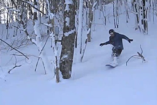 Local ski areas are reporting great conditions and it looks like more snow is on the way, with Ray’s Weather Center predicting another 6 to12 inches for the highest peaks over the next couple of days. On January, 10, we went up to Wolf Ridge Ski Resort in Madison County and encountered powder that’s more typical of the Rockies than the Southern Appalachians. Here’s a short video of what we found.
Snow brings great sledding conditions to Asheville parks
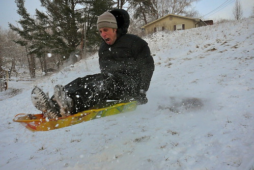
The snowy weather is creating excellent sledding conditions on area hills. Here’s a few photos of Xpress staffers Jake Frankel and Dane Smith as they engaged in an epic long jump competition at West Asheville Park.
Winter wonderland: Snow’s not done yet
Western North Carolinians are waking up to varying amounts of snow this Saturday, Jan. 8 — from a few inches to a foot at higher elevations. And forecasters are calling for more.
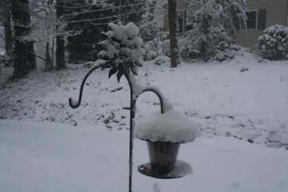
photo by Margaret Williams