

I heard about Catawba Falls as soon as I started hiking in Western North Carolina — how it was so beautiful, but it was such a shame you couldn't hike there anymore. It didn't take me long, though, to realize that the access trail was privately owned, and people shouldn't have been going there in the first place.
The falls themselves have been part of Pisgah National Forest since the 1980s, but the first quarter-mile of the way in was private, leaving the falls effectively landlocked. Longtime hikers said three Doberman pinschers would confront you if you tried to cross that property: "There must have been a change in ownership about 25 years ago. After that, you could no longer go up to the falls easily."
A land conservancy can act much more quickly than a government can, so when the property became available in June 2007, the Foothills Conservancy — based in Morganton — bought the 23 acres to secure access to the falls. I joined the conservancy immediately and made my first trip to Catawba Falls soon after. But we were in the midst of the drought, and the water came down in pitiful little drips. Frankly, I wasn't impressed.
Last month, however, I returned to scope it out for this article. Wow! Thanks to all the rain we've had, Catawba Falls was very impressive; I now understand what the fuss was all about.
Electrifying North Carolina
The 225-mile-long Catawba River winds through the heart of the Carolinas, providing water and power to more than 1.3 million residents. Along the way, it's been dammed to form several lakes, including Lake James and Lake Norman. The Catawba becomes the Wateree River in South Carolina.
The trail to the falls was first a pathway for the Cherokee and then, in the 1800s, a stagecoach route to Asheville. It followed the Catawba River, then Chestnut Branch (a tributary) to Swannanoa Gap.
Rufus Morgan, a portrait and stereograph photographer, took pictures of Catawba Falls in the 1870s to encourage people to hike along the river and view this scenic attraction. In the early 1900s, Col. Daniel W. Adams, a pioneer in the development of hydroelectric power, bought thousands of acres of land in the Old Fort area, including the falls. He built dams to create electricity for the town of Old Fort. The remains of that era can be seen on the way to the falls. In 1928, Adams sold the power plant to a small power company. Eventually, Duke Power Co. acquired the property and closed the Catawba facility.
Walking to the falls
The trail crosses the stream on a bridge and passes a barn. After a quarter-mile, the high water level forces me to rock-hop across the stream, and I reach U.S. Forest Service land.
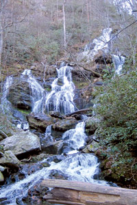
A concrete structure that looks half-built stands on the right, and the shell of an old power plant can be seen across the river. The trail follows the river, passing several wading spots, as evidenced by a pink towel that someone left behind. After passing a beautiful cascade, I arrive at a dam and spillway that fed the first power plant — this is not the lower falls. On the right, a concrete wall is all that remains of a second power plant. After 1.5 miles, I reach a flat area by a pool at the Lower Catawba Falls. The water cascades in multiple stages, gathering more force from side branches as it comes down. This is the end of the maintained trail. Most folks enjoy a snack here and return.
The way to the Upper Falls is steep, rocky, eroded and slippery — and hikers are advised not to venture there for now. As Weaverville resident Ray Sanow said of climbing to Upper Catawba Falls, "It didn't get this technical up to the base camp on Mount Everest." The headwaters of the Catawba lie behind the upper falls.
Recent developments
The Foothills Conservancy now owns 88 acres near the falls. This past October, President Obama signed an Interior Department appropriations bill into law that includes funding to buy the land near Catawba Falls from the conservancy for $713,000.
Tom Kenney, the conservancy's
land-protection director, anticipates transferring the property to Pisgah National Forest this year. Kenney says he hopes "the Forest Service will reroute the trail … so that people can access both the lower and upper falls. Now the markers leading to the upper falls are unofficial." The Foothills Conservancy will apply for a grant to make improvements to the trailhead and build a bridge. At the current water level, the crossing is challenging.
"The Foothills Conservancy," says Kenney, "thanks Congressman Heath Shuler and Congressman David Price of the Raleigh/Chapel Hill area who were instrumental in requesting the funds to allow the access to the falls."
Hike leader and outdoors writer Danny Bernstein is the author of Hiking North Carolina's Blue Ridge Heritage. She can be reached at danny@hikertohiker.com.
The trail to the falls was first a pathway for the Cherokee and then a stagecoach route to Asheville.
Before you comment
The comments section is here to provide a platform for civil dialogue on the issues we face together as a local community. Xpress is committed to offering this platform for all voices, but when the tone of the discussion gets nasty or strays off topic, we believe many people choose not to participate. Xpress editors are determined to moderate comments to ensure a constructive interchange is maintained. All comments judged not to be in keeping with the spirit of civil discourse will be removed and repeat violators will be banned. See here for our terms of service. Thank you for being part of this effort to promote respectful discussion.