

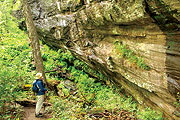
Writing’s on the rock: Ellicott Rock, along the Chattooga River, is history in plain sight. photo by Danny Bernstein
|
The sign, which reads “Ellicott Rock,” points down and toward the river. No mistaking it — I drop my pack on the trail and scramble down. I reach the rock, marked “N G” to designate the North Carolina/Georgia border, and then inch along the bank, looking for the next boundary.
The Ellicott Rock Wilderness, located where North Carolina, South Carolina and Georgia come together, straddles the 15,432 acre Chattooga Wild and Scenic River corridor. The Chattooga was made famous (or infamous, perhaps) by the movie Deliverance, and in 1974 it became the first waterway east of the Mississippi to be added to the national Wild and Scenic Rivers System.
The Chattooga starts in Cashiers, N.C., and travels down to Tugaloo Lake in north Georgia, forming the border between that state and South Carolina for much of its run. Deliverance did not depict north Georgia kindly, becoming a code word for Appalachian stereotypes, but active tourists have never stopped heading to the river.
Deliverance was complete fiction, but North Carolina writer Ron Rash’s book Saints at the River is based on an actual event — a drowning and its controversial aftermath. Rash’s novel is set farther downstream at Raven Chute, where the river is wider and can be negotiated in a canoe or kayak.
Most days the Chattooga’s forested banks are quiet, but it wasn’t always so: In 1810 this section was the site of the Walton War, brought about by a dispute over the Georgia/North Carolina border. At the time, the 35th parallel was accepted as Georgia’s northern border, but no one was exactly sure where it ran. Consequently, the two states could not agree on who owned a 12-mile-wide strip of land in the disputed area.
In the late 18th century this “orphan strip” was home to 50 white settlers’ families, but because neither state policed it, it was also a haven for outlaws and criminals. Georgia laid claim to the section in 1803 and called it Walton County. Both states referred the boundary problem to the U.S. Congress, which did nothing about it. In 1810, North Carolina sent out its state militia to displace the Georgia government, resulting in a battle near present-day Brevard. North Carolina won and took back the area.
Georgia wasn’t satisfied, though, and hired Andrew Ellicott, a noted surveyor from Pennsylvania, to definitively establish the border. In 1811, Ellicott and his large team bushwhacked through rhododendrons and mountain laurel thickets to determine the location of the 35th parallel. He engraved the state boundary on a rock on the east side of the Chattooga River, giving the disputed land to North Carolina. Ellicott Rock, which can be reached only on foot, marks the location.
The hike
The hike (8.7 miles/960 feet ascent) starts at the picnic shelter at the Walhalla State Fish Hatchery and goes west on the East Fork Trail, paralleling East Fork Branch. It then picks up the Chattooga River Trail to Ellicott Rock at the tri-state border.
From the hatchery parking lot (see “The Trailhead” below), follow the paved path and turn left toward the picnic shelter. The area around the shelter is home to a few old-growth hemlocks and white pines. Past the shelter, make a sharp left on the East Fork Trail (it’s marked), where the wilderness area begins.
Soon you cross the east fork of the Chattooga on a wooden bridge. From here on out, water is always at hand as you ford minor creeks and small cascades on steppingstone blocks. You’re walking in the proverbial temperate-rain-forest jungle, with tangled rhododendrons and dog-hobble lining the trail. Tree roots stick up halfway out of the soil, and water drips off moss-covered rocks. Several old-growth hemlocks have somehow escaped the logger’s saw.
At 2.2 miles, the East Fork Trail ends. Turn right and go north on the Chattooga River Trail, which follows the river upstream. A left at the bridge leads to Burrells Falls Road and a campground. This wide junction is a favorite spot for anglers. The river is peaceful here, with small, sandy beaches on both sides.
Cross Bad Creek, on your left, after going through the camping area. On the other side, go up some steps and turn left onto an old roadbed. At 3.8 miles, a huge dome-shaped rock stands across the river from a little beach.
The rock
You’ll know you’ve reached your destination by the colored pieces of flagging tape and the sign pointing down to Ellicott Rock.
If the river isn’t too high, carefully scramble down the banks of the river. Note: The ground here is muddy and slippery. If you expected Ellicott Rock to be a big monument with a commemorative plaque, you’ll be disappointed; Ellicott, apparently, was a man of few words.
Don’t climb back up just yet. A few feet downstream you can see Commissioner Rock, which establishes the North Carolina/South Carolina border with an inscription:
LAT 35
AD 1813
NC + SC.
To find the Georgia/South Carolina boundary, look toward the middle of the river for the large rock island called Chattooga Rock. The inscription on the survey marker — the lower, downstream part, visible from the shore — says “SC 1996” where the three states come together. And by the way, don’t wade out to the middle of the Chattooga River. The water is swift and deep, and no one is likely to rescue you.
So read Saints by the River — and sign up for the hike! (See Outdoor Journal)
The trailhead
From Cashiers, take N.C. 107 south and then S.C. 107 for 12 miles. Turn right into the Walhalla State Fish Hatchery and drive 2.2 miles to the trailhead. (At the split, take the left fork over the river.)
[Danny Bernstein, a hike leader and outdoors writer, can be reached at danny@hikertohiker.org.]
Before you comment
The comments section is here to provide a platform for civil dialogue on the issues we face together as a local community. Xpress is committed to offering this platform for all voices, but when the tone of the discussion gets nasty or strays off topic, we believe many people choose not to participate. Xpress editors are determined to moderate comments to ensure a constructive interchange is maintained. All comments judged not to be in keeping with the spirit of civil discourse will be removed and repeat violators will be banned. See here for our terms of service. Thank you for being part of this effort to promote respectful discussion.