


Timeless beauty: Bernard Elias’ 1970 photograph of Cold Mountain. photo by Bernard Elias
|
When I moved to Asheville, the first book I read about the area was Strangers in High Places by Michael Frome. Among the many pictures sprinkled throughout the book was a familiar face, that of Bernard Elias.
At nearly 88 years old, Bernard Elias is the oldest member of the Carolina Mountain Club and likewise has the longest tenure with the outfit (since 1941). An Asheville native, Elias has been a Navy photographer, a film-processing specialist for Kodak and a world traveler, but he is best known around here as a hiker and an expert on Southern Appalachian trails.
Wearing his trademark red Swiss-guide hat, Bernard recently explained his fascination with the mountains. In 1929, he recalled, the Asheville Times (forerunner of today’s Asheville Citizen-Times) organized a 10-day expedition to the Smokies, which weren’t a national park yet. The explorers brought 10 homing pigeons with them to deliver news of their progress. Each day, they wrote down what they had done, stuffed the report into a tiny aluminum capsule tied to a pigeon’s leg, and sent the bird back to Asheville.
“I was 10 at the time,” Elias recalled. “I couldn’t wait for the paper to be delivered. That’s how I got so interested in the Smokies.”
A party from Knoxville arranged a similar expedition, and the two groups met on Clingmans Dome. One explorer from the North Carolina group was an Eagle Scout, a detail that Elias seized on immediately.
“I joined the scouts as soon as I could,” he said. Eventually, he made Eagle Scout himself.
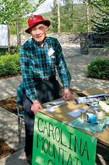
Tireless trail hound: Elias works a Carolina Mountain Club event in April. photo by Danny Bernstei
|
Elias grew up in Biltmore Forest and still lives there in the family home. When he was 14, he and a friend lay on the front lawn and looked up toward Mount Pisgah, wondering how hard it would be to walk from their neighborhood to the top of the mountain. They decided to try it. The boys didn’t have sleeping bags so they took army blankets, a pup tent and cans of food — there were no freeze-dried meals back then. They jumped the fence into Biltmore Estate — the place was not as heavily patrolled as it is now — and managed to get someone to row them across the French Broad River. From there (this was before the Blue Ridge Parkway, mind you), all they had to guide them was the Shut-In Trail, a route originally built by George Vanderbilt to get him from his estate to Buck Spring Lodge. The boys took two days to reach Mount Pisgah.
During World War II, Elias was a Navy photographer, which led to a career with Kodak — first in Hollywood, Calif., and later at the company headquarters in Rochester, N.Y. In the early 1950s, he went to India with a company that made educational films such as How to Keep Your Well Clean.
“At the time,” said Elias, “movie theaters in India had to show these films before the main movie.” After that assignment, he toured the country, rode elephants and went skiing for the first time. He went tiger hunting with a man from New Zealand whom he’d met in Bombay at the Taj Mahal Hotel. He shot photos and movies while the other man hunted, but fortunately, Elias says, “He never got a tiger.”
After a career that took him around the world, Elias returned to Asheville and went to work for Ball Photo, which was then located on Wall Street. In the autumn of 1970, Elias took a famous picture of Cold Mountain in the fall from the site of Buck Spring Lodge. The same view could not be shot today, as trees block the view. But Elias’ photo is still for sale at The Compleat Naturalist in Biltmore Village.
A legacy on paper
Elias considers 100 Favorite Trails of the Great Smokies and Carolina Blue Ridge to be his greatest accomplishment. He first developed the map in 1966. According to him, five or six people from The Carolina Mountain Club and the Smoky Mountains Hiking Club divided up the trails being considered for inclusion. After that first effort, Elias took the project over and subsequently updated the map 13 times. “I re-walked 10 to 12 trails a year to check them,” he said.
The map spans the region from Boone to the Cherokee National Forest in Tennessee. The back describes each hike, including the nearest road, the total mileage and the altitude gain. Photos on the map show men dressed in sports coats and button-down shirts, a pre-fleece approach to trail dress.
“You could scan the map without having to read five or six pages in a trail guide for each hike,” Elias explained. Both the National Park Service and the National Geographic Society have used the map as a reference. The map originally sold for a dollar. Now, 12 years after its last publication, those lucky enough to still have a copy have been offered upward of $300 for it. Demand for the map hasn’t dried up either: The Carolina Mountain Club still gets requests for it with two dollars tucked in the envelopes.
A history of activism
In the 1960s, Elias was very active in opposing the Transmountain Road through the Smokies. Envisioned as an alternative solution to the long-stymied North Shore Road, the 35-mile route would rise from Monteith Branch, climb the upper reaches of Hazel Creek, cross the divide at Buckeye Gap and connect Bryson City with Townsend, Tenn. At the time it was proposed, Swain County said it would agree to substitute the Transmountain Road for the one specified in the original 1943 agreement with the federal government (See “The Road Less Traveled,” March 8 Xpress).
“We organized club members to go to meetings and write letters opposing the road,” Elias remembered. “We worked as hard on that as people are working now against the North Shore Road.” In 1967, the secretary of the interior killed the project.
Now, just a few years shy of his ninth decade, Elias is not content to leave the North Shore Road fight to younger folk. “I am violently opposed to the road,” he explained. Accordingly, he followed his belief with action recently and sent — picked out on his manual typewriter — to the National Park Service expressing his support for the financial settlement with Swain County. “The road,” he wrote, “would be a desecration to the wilderness and to the classic bear habitat of the area.”
[Danny Bernstein, a hike leader and outdoors writer, can be reached at danny@hikertohiker.org.]
Before you comment
The comments section is here to provide a platform for civil dialogue on the issues we face together as a local community. Xpress is committed to offering this platform for all voices, but when the tone of the discussion gets nasty or strays off topic, we believe many people choose not to participate. Xpress editors are determined to moderate comments to ensure a constructive interchange is maintained. All comments judged not to be in keeping with the spirit of civil discourse will be removed and repeat violators will be banned. See here for our terms of service. Thank you for being part of this effort to promote respectful discussion.