


In this year’s “Best of WNC” poll, Mountain Xpress readers voted the Blue Ridge Parkway the region’s best place to hike. I don’t think they really meant walking on the asphalt; more likely they were referring to the Mountains-to-Sea Trail, which runs alongside the Parkway in this part of the state.
An ambitious trail project-in-the-making, the MST will eventually traverse North Carolina from the summit of Clingmans Dome (6,643 feet) in the Great Smoky Mountains National Park to Jockey’s Ridge State Park on the Outer Banks. At present, the trail is more or less equally divided between footpaths, rural roads and N.C. Department of Transportation bike routes. The result is a unique 935-mile route across the state, linking high peaks, green valleys, cool streams, farmland and sand dunes.
Raleigh-based environmental consultant Jeff Brewer is president of the nonprofit Friends of the Mountains to Sea Trail (www.ncmst.org), which organizes volunteers to build and maintain the various trail sections. “When I was only about 8 years old, I recall my dad telling me that there was going to be a cross-state trail called the Mountains-to-Sea-Trail. I was amazed,” says Brewer.
The impetus for the trail was the 1973 North Carolina Trails System Act. The concept has now become reality, and today Brewer is a big part of it. “I would have never guessed that [one day] I would be helping out so much,” he says.
En route to the coast, the trail passes through three national parks—the Great Smoky Mountains National Park, the Blue Ridge Parkway and Cape Hatteras National Seashore—as well as several state parks and three national forests (the Nantahala, Pisgah and Croatan). Users can choose to bike or canoe parts of the trail where the footpath is not yet completed.
“The mountain section of the MST is just as scenic as the [Appalachian Trail] in North Carolina,” Brewer maintains. Farther east, it reveals a different face of our landscape. “In the Piedmont and coastal parts, the MST shows the hiker that North Carolina is a true agriculture state,” he notes.
Our MST
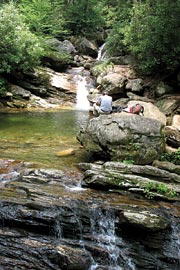
In Western North Carolina, the Mountains-to-Sea Trail was built using existing trails, old logging-railroad grades and carriage roads whenever possible. Altitude determines the walking conditions: A pleasant stroll near the French Broad River Bridge at about 2,000 feet elevation can turn into a cold, snowy trek atop Mount Mitchell at 6,684 feet. The trail ascends and descends according to the contours of the Blue Ridge Parkway, drifting away from it and returning to it until the Parkway leaves the state altogether in the vicinity of Stone Mountain State Park, at Roaring Gap. The hiker walking the mountain portion of the MST will come to understand the Parkway nearly as intimately as the trail itself.
The Carolina Mountain Club is responsible for the route from Heintooga Road at the edge of the Qualla Boundary in the Smokies to Black Mountain Campground, a distance of about 130 miles. The club is currently building a 10-mile section of trail west of Balsam Gap (see below).
Part of the MST’s appeal is that it’s so varied, says Don Walton, supervisor for the club’s piece of the trail. “You can take an almost flat walk on the MST through Asheville with your dog. Or you can walk from Double Top Mountain Overlook (at milepost 435.3 on Old Bald Ridge) to Bear Pen Gap (at milepost 427.6). It’s about eight miles and as rugged as anything you’ll find in the East. It has all the elements of a real wilderness. In addition, a section of the MST east of Bear Pen Gap goes through the Middle Prong Wilderness.”
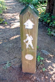
But despite its wilderness feel in places, the trail remains very accessible. From almost any Parkway pull-off where the MST’s white circles are visible, you can get on the trail and be in the woods in seconds, walking as long as you care to and then returning the same way.
Walking the trail
As an advocate, Brewer felt he needed to know the trail backward and forward, so in 2003 he set out to walk its length, completing it in 55 days. Brewer was moving fast; the Friends suggests that hiking the trail will consume two to three months, but the group doesn’t have much empirical evidence to support that estimate. Brewer is one of only 11 people who have walked the Mountains-to-Sea Trail end to end.
The first person to do so was Allen de Hart, now considered the “father” of the MST. After completing the trail in 1997, de Hart turned his experiences into a book, Hiking North Carolina’s Mountains-to-Sea Trail (University of North Carolina Press, 2000). De Hart is retired from Louisburg College, where he was Brewer’s instructor in a hiking-and-backpacking course, passing along his enthusiasm for the MST. De Hart’s book is a little outdated now, but it remains the only available guide to the entire trail.
In 2003, Katie Nelson, a 79-year-old great-grandmother, became the oldest person to complete the trail.
The logistics of through-hiking the MST are much more complicated than they are the Appalachian Trail. With no shelters along the trail and few legal places to camp, backpackers have to be creative in finding a place to spend the night. You can’t camp on Parkway land, but where the trail borders national-forest land, you can camp anywhere.
And since many parts of the MST are still in the design-and-construction phase, few services have sprung up to cater to backpackers: no hostels, shuttle services or all-you-can-eat buffets. There’s also little in the way of chat rooms, Web sites, blogs, published personal accounts or mythology related to walking the MST—essentials for hikers trying to get a feel for the trail. “You need to plan more than if you’re doing the AT,” notes Brewer. “You’re not going to see a lot of people.”
[Hike leader and outdoors writer Danny Bernstein is the author of Hiking the Carolina Mountains (Milestone Press, 2007). She can be reached at danny@hikertohiker.com]
Ten miles of the Mountains-to-Sea Trail in our area have been approved but still need to be built. Readers who voted this the region’s best place to hike might want to invest a little sweat equity in helping make it happen. On Saturday, Nov. 10, the Carolina Mountain Club will hold an MST workday to continue the trail. Visit www.carolinamtnclub.com for details.
Before you comment
The comments section is here to provide a platform for civil dialogue on the issues we face together as a local community. Xpress is committed to offering this platform for all voices, but when the tone of the discussion gets nasty or strays off topic, we believe many people choose not to participate. Xpress editors are determined to moderate comments to ensure a constructive interchange is maintained. All comments judged not to be in keeping with the spirit of civil discourse will be removed and repeat violators will be banned. See here for our terms of service. Thank you for being part of this effort to promote respectful discussion.