

Asheville is kind of walkable, if the ratings from the site Walk Score are any indication. The site, which encourages walkable neighborhoods and rates them, scores Asheville overall at a 57 or “somewhat walkable.”
Walk Score, developed by the Seattle, Wash.-based software company Front Seat, measures how walkable cities, neighborhoods and individual properties are by their proximity to nearby services. Asheville’s score compares favorably with other North Carolina cities such as Charlotte (average score 44), Greensboro (49), Raleigh (49), Durham (44) and Wilmington (53). Though, while Asheville may have defeated Portland, Ore., for the Beer City USA title, that city ranks far higher on Walk Score’s calculus (71).
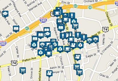
Of course, within Asheville, neighborhoods’ walkability varies drastically. Downtown is a “walker’s paradise” with scores in the high 90s; just nearby Montford scores a 62 and Clingman Avenue an 80. Over in West Asheville, Haywood Road scores 68, Burton Street a 60. Then there’s Haw Creek, which rates a 14, or Pisgah View at 22.
Like all attempts to quantify this sort of thing, Walk Score has its own criteria, specifically in its emphasis on proximity to business. In measuring Asheville’s walkability, what criteria would you use, and how does the city rate in your opinion?
— David Forbes, senior news reporter
.
Lower than that. You have to drive from many neighborhoods just to park where you can walk. Streets are narrow, hilly, and curvy. Furthermore, only 7% of Asheville has sidewalks. And that includes the high percentages of the downtown and Haywood area, meaning most neighborhoods have an even lower percentage than the misleadingly high 7%. Additionally, new construction has razed forests and mountain sides in order to install kit homes in previously wooded areas of established neighborhoods, without adding sidewalks. So really what’s happening is the population density is increasing in a place with virtually no sidewalks and dangerous mountain roads. The formula they use obviously does not consider these facts.
Here in downtown Spartanburg, I’m getting a 74, or “Very Walkable.” That seems to fit.
I’d say the criteria should be more specific than just proximity to “business” in a general sense. Areas should be rated on how easy it is to walk to key services such as groceries, public transit, even doctors offices and the like. Being able to walk to the neighborhood pub is nice but not exactly weighted high on my personal list of priorities.
I’ve got 83/100 walk score in North Asheville (off Edgewood b/t Kimberly and Merrimon). Lots of sidewalks, crosswalks with electric signs, public transportation, etc. I can walk Downtown with no problem!
However, I used to live in West Asheville and it was a shame that sidewalks didn’t connect that side of town with the Downtown core. They seem to be fixing that with the Clingman Greenway, though.
Where is the Clingman Greenway?
ClingmanForest Greenway
This wooded corridor begins at Aston Park at Hilliard Avenue and follows an existing sewer line and stream down to Clingman Avenue. There are potential connections to Aston Park, Asheville Middle School, YWCA, future affordable housing complex at the corner of Hilliard and Clingman Avenue, Owens Bell Park and surrounding residential areas.
Good deal. Sounds like it will go close to Amazing Savings and the other new shops on S French Broad above Hilliard.
Remember, we must support City Council in their GREEN Agenda and NEVER create more environmentally UNfriendly CONCRETE sidewalks.
Naturally draining gravel paths are the GREEN preference.
Perhaps a ‘$timilus Job$ Program’ can be secured to replace existing sidewalks with gravel paths.
IF we are to truly be GREEN in Asheville! Right?
As someone who works with Pedestrian Plans, ADA issues, and complete streets, the attention Walkscore is getting is very frustrating.
I have done my best to discourage planners and transportation professionals from using it because it creates a false sense of what the environment is like for pedestrians. It does very well in downtown and old neighborhood environments. However, we already know that downtown Asheville is walkable.
Try Walkscore with this: “Tunnel Road and Riceville Road, Asheville, NC”. You get: “71 – Very Walkable.”
If the Asheville City Council used Walkscore, they could tell all the residents of East Asheville and Haw Creek that things are just fine and they don’t need sidewalks because they are “very walkable.”
The intersection of Tunnel Road and South Tunnel Road receives a 68: Somewhat walkable, as does Florida Avenue and Patton Avenue score. Are these places more walkable than Haywood Road and Montford?
Would you like to walk in that area with your child? Try crossing Patton Avenue and tell me how walkable it is.
Walkability is not about how many businesses are within a certain distance of a location. That means nothing if there is no way to get there.
Walkscore does not account for the features that make walking possible: the actual walk route; whether or not there are sidewalks; whether or not there are connecting streets; whether or not the design of building and parking lots are pedestrian-friendly; and the conditions of those sidewalks if they exist.
Don, I think you make some good points.
Walkscores are much more accurate for pre-WWII neighborhoods.
Walkscores should really be called “retail density scores.” These should be regarded as one component of true walkscores. Still, I think Walkscores could be useful for planners. For instance, they could focus pedestrian improvements and street redesigns on areas that are known to be unwalkable and that nonetheless have high Walkscores.
BTW, I live on Louisiana between Haywood and Patton (one car for a family of four). We used to live with no car on Lookout Drive in North Asheville (across Merrimon from Asheville Pizza and about three minutes uphill). Both addresses received scores in the 70s, which I thought were pretty fair. But the North Asheville address scored a few points higher, whereas I actually think the W. Asheville location is better–because of the proximity of a full-service grocery store, which is what I regard as the single most important neighborhood amenity. (Currently, a convenience store helps a Walkscore as much as supermarket, though the website admits that this is a problem.)
my neighborhood ranks a 14!
the closest sidewalk and bus stop are over a mile away, but the city gladly taxes me :)
Good point Jonathan on how to focus improvements where “retail densities” are high but facilities are lacking. That would help to identify places that could be made walkable with some real potential for results.
In north Asheville I’d rate Kimberly and Grove Park very good, Charlotte street marginal and Merrimon AWFUL. When walking to town I pick Central Ave / Washington Rd “corridor” due to low traffic and sane speeds.
Another thing I’ve noticed about Walk Score is that it recognizes every McDonalds and Wal-Mart as a business but misses a lot of smaller businesses, meaning that a neighborhood with a lot of local, independent business mixed right in with the housing might fare worse than a neighborhood backing up to a highway commercial strip but separated from it by fences.
That said, I’m glad people are at least talking about walkability and mixed land uses in some form.