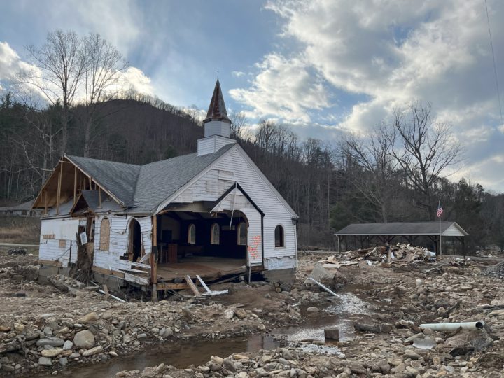
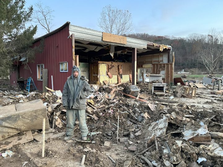
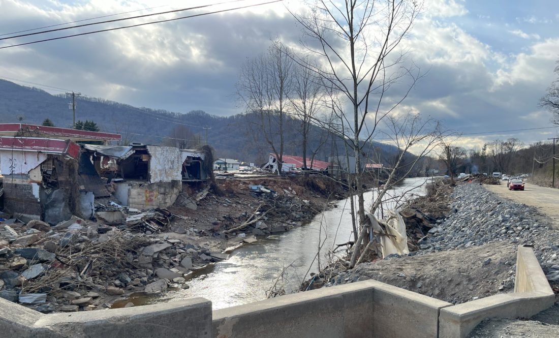
A key tool government and individuals in Buncombe County will have to rely on to decide how to rebuild after Tropical Storm Helene is old and, according to critics, unreliable.
All but a few of the maps intended to show areas in the county most prone to flooding were adopted almost 15 years ago. They have no provision for increased risk of flooding since then caused by climate change or construction of roads, buildings and other hard surfaces, or how much those factors may make flooding still worse in the future.
The maps, produced by the state government for the Federal Emergency Management Agency (FEMA), are the basis for local government ordinances that determine what can and cannot be built on land near creeks and rivers. These maps determine which homeowners must buy flood insurance and which can legally skip it. They can also play a part in decisions over where it is wise to place buildings and where it is not.
Your middle school science teacher probably taught you that the warmer the air is, the more moisture it can hold – and drop in a rainstorm. But the flood maps don’t account for a warmer climate. Instead, they are based on calculations of rainfall probabilities that in turn “are based on a stagnant climate, so you can infer that they’re not that accurate,” says retired meteorologist Marjorie McGuirk, an Asheville resident who worked in the climate field for decades.
That uncertainty could play a role in future discussions over whether to toughen restrictions on building in or near floodplains to lessen damage caused by future storms. Those debates will also touch on concerns over private property rights and the area’s shortage of affordable housing: The more land that is subject to tighter rules on building, the higher the demand for remaining buildable tracts is likely to be.
“By not taking climate impacts and other factors into account, communities are using bad flood maps to make even worse decisions about where it’s safe to build,” Rob Moore, director for flood solutions and environmental health at the national Natural Resources Defense Council, wrote earlier this year.
Where rules apply
With many local residents either out of work, out of their former homes or both because of Helene, meeting the immediate needs the storm created is the main focus of government and local residents nowadays. But, people in the field of disaster management speak of a disaster response cycle that eventually turns to a phase when, as McGuirk puts it, “We look to make it so that the next disaster won’t be a repeat of the previous one.”

Flood plain maps delineate the special flood hazard area — often called, somewhat misleadingly, the 100-year flood plain — where mapmakers calculate there is a 1% chance of flooding in any given year. They also typically show areas where the flooding possibility is 0.2% annually, termed the 500-year flood plain.
Asheville and Buncombe County both require that the lowest inhabitable floor in new structures built in the 100-year floodplain be at least 2 feet above the level floodwaters would reach in a 100-year flood. Buildings already in existence when the rules were adopted are grandfathered unless they are damaged to the point where they have lost half or more of their value. Then, they can’t be rebuilt without complying. There are no special requirements for buildings in the 500-year floodplain.
People buying a home within the 100-year floodplain must buy flood insurance if their mortgage is backed by the government, as most are.
But, there are serious doubts about the maps’ accuracy, even when they were first published. By one statistical measure, they are considerably less reliable than many calculations used in engineering work. FEMA says a quarter of all insurance claims for flood damage occur outside the 100-year flood plain — even though homeowners in those areas aren’t required to buy flood insurance and often don’t.
David Easterling, a climate scientist at the National Oceanic and Atmospheric Administration’s (NOAA) National Centers for Environmental Information’s Asheville office, says drawing accurate flood maps is inherently difficult because rainfall and flood records only go back so far. How confidently can you say a particular level of flooding should happen an average of once every 500 years when there’s less than 500 years of data?
Climate change and property development increase the chances that flood maps underestimate the risk. The number of housing units alone in Buncombe County increased 14% from 2010 — when the most recent flood maps came out — to 2020.
The NCEI says the temperature of the Gulf of Mexico — a key factor in the intensity of hurricanes — rose about 1.8 degrees from 1970 to 2020, and NASA says the water was unusually warm as Helene gathered strength and headed for Western North Carolina. At least three quick studies agree that climate change made Helene more likely, more intense or both, though they say natural variation in the weather was a larger factor.
“Climate change had an influence on [Helene] and definitely made it worse. How much worse is hard to say,” Easterling says.
He, like many scientists, expects that effect to increase: “If the climate continues heating up … you’re going to have more of these Helene-type events.”
Nathan Pennington, Buncombe County planning director, says the maps at present “do a pretty good job” predicting where flooding will happen, but he adds that it is a challenge for mappers to keep up with climate change: “The problem is we’re starting to see patterns change. We’re starting to see more 500-year events.”
FEMA is looking at adding a forward-looking component to flood maps. For now, they are based entirely on the past, not what’s expected to happen next. New maps for Buncombe County should be approved in three or four years, Pennington says.
In response to questions from Xpress, FEMA’s public information office said in a statement that its flood maps “are snapshots in time designed to show minimum standards for flood plain management and the highest risk areas for flood insurance. They are not predictions of where it will flood, and they don’t show where it has flooded before.” Owners of property outside the 100-year flood plain should not assume it will never flood, the statement says.
“Maps are updated on a continuous basis” and, “The age of a map does not necessarily reflect its accuracy,” the statement says.
Xpress also emailed questions to the public information office for the N.C. Department of Public Safety on Nov. 22. No response had been received by press time.
The cost of safety
Early discussions about how to respond to Helene include philosophical differences over how much government should try to reduce the risk of flood damage and uncertainty over how likely flooding is in areas above the 100-year flood plain shown on current maps.
Tony McEwen, Carolinas director for advocacy group American Flood Coalition, says he wants FEMA to improve its mapping, but he adds that even without better maps, it is obvious that local governments need financial and other help to combat flooding.
“Maybe Helene itself is not the new normal, but the fact is that Western North Carolina has had to deal with flooding issues in the past and will have to deal with them going forward,” he says.
He says efforts to make communities more resilient more than pay for themselves in reduced costs when floods occur. “It’s not easy to proactively spend money … but on this, it makes so much sense,” McEwen says.
Lisa Raleigh, executive director of environmental nonprofit RiverLink, points to Tennessee Valley Authority (TVA) research indicating that Buncombe County was hit by a flood in 1791 that was higher than the infamous flood of 1916, which claimed about 80 lives. TVA reports from the 1960s chronicle several other floods during the 19th and 20th centuries. And, other floods – notably, two in 2024 that caused major damage across Buncombe County – have followed their publication.
“We’re flood prone,” Raleigh told the local Sierra Club chapter Nov. 6. “We have endless incidents of nuisance to medium flooding events that result in property and habitat damage.”
Raleigh argues, “We need to use Helene as a benchmark.” She doesn’t have specific policy changes in mind but warns, “We truly must consider making more ‘room for the rivers,’ or we are going to continue to find ourselves in different versions of this disaster.”
Mike Summey, a major owner of rental housing in Buncombe County, is at the opposite end of the spectrum. He says, “Too many people want the government to protect them from everything.”
If everyone drove around in tanks, there would be fewer injuries in traffic accidents, but the cost would be prohibitive, he says.
“Whatever happened to personal responsibility?” Summey asks. “If I want to go down there and build a building in the floodplain and have it wash away, that’s my business,” he says.
McGuirk, the retired meteorologist, disagrees. She notes the broad efforts by government, nonprofits and ordinary people to help residents hit by Helene. That’s on top of ongoing services like police, firefighting and emergency management to keep people safe from a variety of threats, including flooding, whether they put themselves in harm’s way or not.
“Everyone pays when someone is in need of aid,” McGuirk says. “The cost of risk is shared by all.”
Building resiliently

Pennington says it would be “very, very, very hard” for local governments to plan to combat risks from another Helene but there are options to improve the community’s ability to handle flooding. He says members of the public are moving away from the idea that they should just rebuild whatever the last flood damages.
“The calls I’m getting now are, ‘How do I build back more resiliently?’ That’s different than the calls I’ve gotten after other floods,” he says.
He’s pushing property owners to get insured: “If you live near a watercourse, if you live near a babbling brook, you need flood insurance.”
Keith McDade, head of a new master’s degree program in applied climate studies at Warren Wilson College, says there will have to be “a community conversation” about possible changes in rules affecting flooding. That could include more steps to control stormwater or allowing denser development away from streams in addition to floodplain rules.
“I think it’s nice to hope that [a storm like Helene] won’t happen again, but I think it is prudent to plan for the possibility,” he says. On the other hand, “We have to continue to invest in our affordable housing and maintain affordability.”
Those conversations will impact people like Jason Farr and his family. Before Helene, the Farrs lived in a home on a small rise near the Swannanoa River in East Asheville. Floodwaters got so high after they evacuated that their former home was not even visible on a neighbor’s drone footage of the storm.
Common sense suggested that the property could flood, but, “I never in a million years thought the water would get over the roof of the house,” he says.
Farr says he and his wife have experienced sticker shock as they look for a permanent new home. He doesn’t know where they will end up but says they have already decided, “It’ll be up a mountain somewhere,” far above the flood plain.


Before you comment
The comments section is here to provide a platform for civil dialogue on the issues we face together as a local community. Xpress is committed to offering this platform for all voices, but when the tone of the discussion gets nasty or strays off topic, we believe many people choose not to participate. Xpress editors are determined to moderate comments to ensure a constructive interchange is maintained. All comments judged not to be in keeping with the spirit of civil discourse will be removed and repeat violators will be banned. See here for our terms of service. Thank you for being part of this effort to promote respectful discussion.