


What began as a moment of simple curiosity for one local man morphed into a five-year project that combined some of the oldest map technologies with some of the newest — resulting in an extensive guide to the Blue Ridge Parkway and other select scenic areas in the region. The book, Asheville-based photographer Tim Barnwell says, is the only one of its kind and scope in the nation.

“When it comes to new projects, I’m always trying to find something that’s unique,” says Barnwell, adding that he hopes his latest book will help locals and tourists alike more fully enjoy the natural beauty of the region.
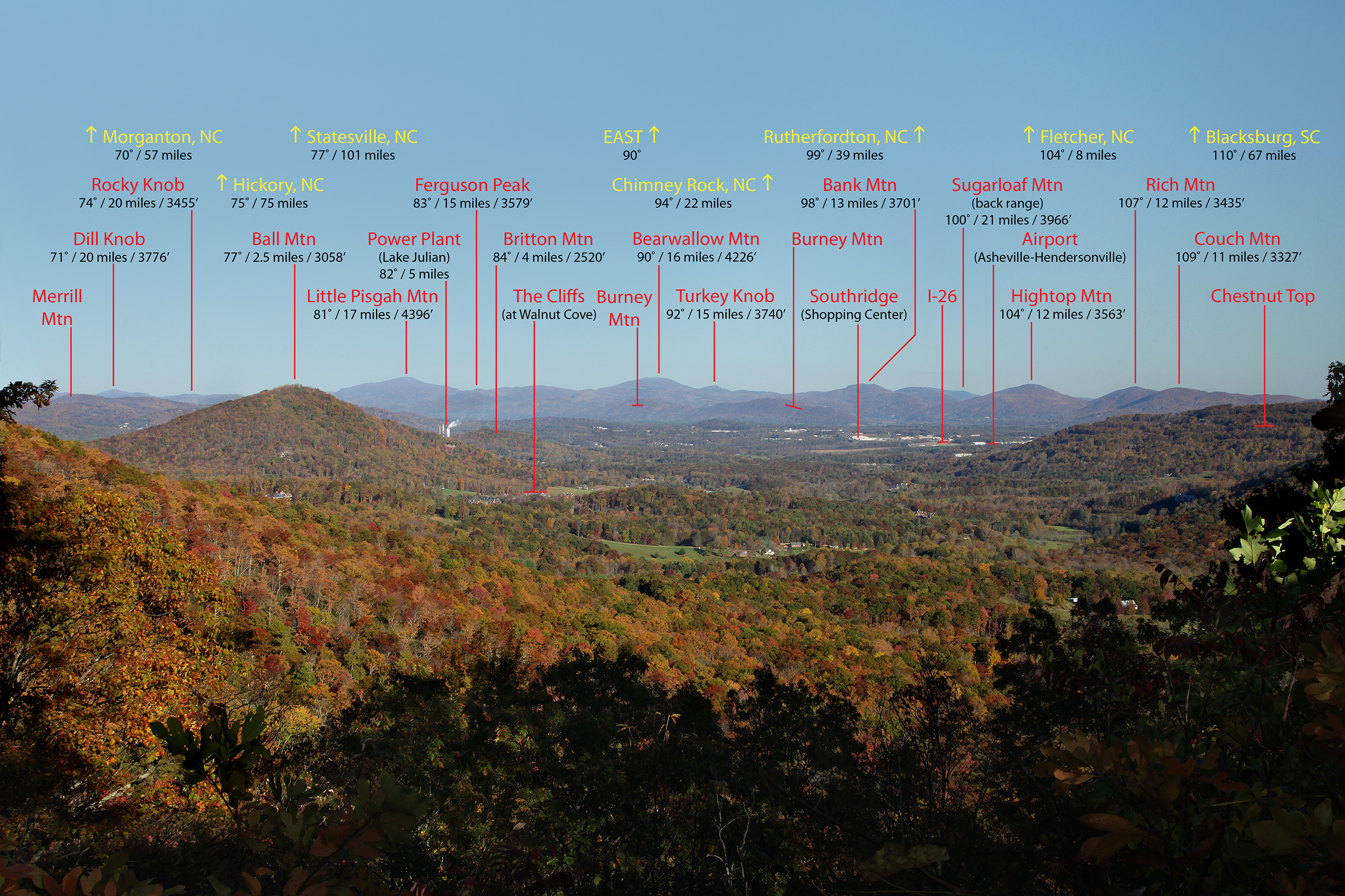
Blue Ridge Parkway Vistas: A Comprehensive Identification Guide to What You See from the Many Overlooks is Barnwell’s fourth publication and contains 120 glossy pages of panoramic photos, historical information and travel tips. It covers more than 40 overlooks along all 469 miles of the Blue Ridge Parkway, as well as vantage points from such Asheville-area points of interest as St. Joseph’s Hospital, Asheville Mall, Chimney Rock Park and the Biltmore Estate.
A Western North Carolina native, UNC Asheville alumnus and the son of schoolteachers in Madison and Swain counties, Barnwell currently lives in his childhood house. He says cruising the parkway is a cherished pastime, but the lack of information about what was visible along the historic road left him wanting more.
“At some point, it occurred to me that I ought to know more than I do,” he says. One particularly frustrating afternoon on the Blue Ridge Parkway nearly six years ago inspired Barnwell to embark on this often-frustrating adventure, he says.
“I was on the parkway, one time, at the Hominy Valley overlook — and there is this really sharp peak out there. I couldn’t really figure out what it was,” he recounts. “It really bothered me.”
He says he took notes about his perceived location of the peak, wrote down the GPS coordinates from the unit in his car and used a pocket compass to make rough calculations while standing at the overlook on the Buncombe-Henderson county line.
“When I got back home, I got some maps out, and I started trying to figure out what it was,” he continues. He initially concluded that it was Sandy Mush Bald. Yet, doubts lingered in his mind as he struggled to find a resource to help him pinpoint distant mountain peaks.
“I thought that I could get on Google Earth or some other kind of software, and I’d just go take pictures, and somehow I could find something that would show me what the peaks were, but that’s not the case,” says Barnwell. “With Google Earth, you’re looking from the satellite, so you’re looking down — you’re not really looking out across the horizon.”
Barnwell then began the process of photographing views from numerous parkway overlooks, then painstakingly combing through maps and topographical computer software to determine what exactly could be seen from each location.
“It ended up being a lot more technically involved than what I had envisioned, and I don’t know that I would have pursued it if I had realized that,” Barnwell admits. “In fact, I quit many times for months. It was just so frustrating. Then, I’d just go back and start trying again.”
Each page features a stunning, full-color photo with digitally overlaid text providing information about the compass heading, distance and elevation of visible peaks, towns, bodies of water, buildings and other landmarks.
When it came time for him to complete the entry for the Hominy Valley overlook, Barnwell discovered his initial determination about the mysterious, pointed peak was incorrect. It was actually Rocky Face Mountain, which sits in Candler and is 11 degrees north of Sandy Mush Bald.
Barnwell is now working on another guidebook in a similar style, this time of the area surrounding the Great Smoky Mountains, tentatively set to be published next spring. It will include aerial photographs of such Tennessee locations as Fontana Dam, Cade’s Cove and Gatlinburg.
Community book signings are scheduled for Sunday, Oct. 18, from 1 to 3 p.m. at the Pisgah Inn; Saturday, Oct. 24, from 10 a.m. to noon at Penland’s Store on Main Street in Marshall; Saturday, Oct. 24, from 2 to 4 p.m. at the Blue Ridge Parkway Visitor Center near Asheville; and Sunday, Oct. 25, from 10 a.m. to 1 p.m. at Craggy Gardens Visitor Center on the Blue Ridge Parkway.
Before you comment
The comments section is here to provide a platform for civil dialogue on the issues we face together as a local community. Xpress is committed to offering this platform for all voices, but when the tone of the discussion gets nasty or strays off topic, we believe many people choose not to participate. Xpress editors are determined to moderate comments to ensure a constructive interchange is maintained. All comments judged not to be in keeping with the spirit of civil discourse will be removed and repeat violators will be banned. See here for our terms of service. Thank you for being part of this effort to promote respectful discussion.