
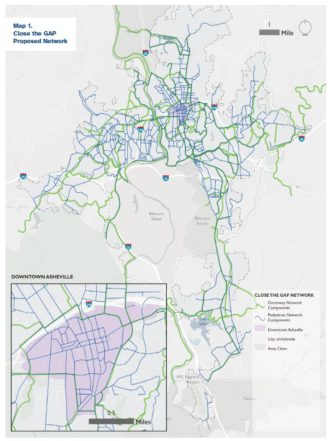
The policy aims to increase the connectivity of greenways, improve sidewalks and bike lanes and make public walkways friendlier for disabled residents.


The policy aims to increase the connectivity of greenways, improve sidewalks and bike lanes and make public walkways friendlier for disabled residents.
The nearly 75-year-old facility was identified as a potential historic resource through the city’s African American Heritage Research Survey.
As presented by Lucy Crown, the city’s greenways program planner, Close the GAP combines a proposed map of greenway and pedestrian networks with updates to city policies and design standards. Asheville City Council is scheduled to vote on the proposal in July.