From the Institute for Climate Education at A-B Tech: One of the most amazing things about living in Western North Carolina is the ability to watch the Earth system move through its annual climate cycles. That is especially true for those of us who have moved here from other regions, especially those that, perhaps, do not progress through these cycles in such grand fashion.
The images below highlight how fast the changes occur in our mountains. Frozen Knob is a mountain in Madison County that shows great color each fall. On Oct. 11, color had just started to appear on the mountain, but by this week, the greens are giving way to the yellows, oranges and rusts of fall.
>
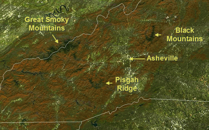
The ever-watchful eyes of NASA’s Earth Observing System add another layer for appreciating these annual cycles — from the vantage point of 440 miles above the Earth, thanks to the MODIS (Moderate Resolution Imaging Spectroradiometer) instrument aboard the Terra satellite. The image below was taken just before 12:30 p.m. on Wednesday of this week, as the Terra satellite passed overhead. You can see the amber color of fall across the mountain slopes and if you look carefully, you can even see the dark colors of the spruce-fir forests that dominate the highest elevations of the Great Smoky Mountains, the Black Mountains and the Pisgah Ridge.

Image Credit: NASA and the Space Science and Engineering Center (SSEC) at the University of Wisconsin-Madison.
(To see satellite images from summer, winter and spring, look back at the Fun Facts e-mail for August 16, 2012 here.)
These next couple of days may be the last chance to catch this year’s fall colors at the mid-elevations. A big change in the weather is coming this weekend: Significantly cooler air will move in with a cold front. So, make the time to get out and enjoy the sights!
The Institute is hosting a free public seminar on Thursday, Nov. 8, at 6 p.m. at Ferguson Auditorium on the A-B Tech Asheville campus. Meteorologist Tom Ross will present the long range winter weather outlook for this winter. Join us and learn the latest about El Nino and whether or not it will have an impact on our winter. Click here for more information including an informational flyer and a map.


Before you comment
The comments section is here to provide a platform for civil dialogue on the issues we face together as a local community. Xpress is committed to offering this platform for all voices, but when the tone of the discussion gets nasty or strays off topic, we believe many people choose not to participate. Xpress editors are determined to moderate comments to ensure a constructive interchange is maintained. All comments judged not to be in keeping with the spirit of civil discourse will be removed and repeat violators will be banned. See here for our terms of service. Thank you for being part of this effort to promote respectful discussion.