


Milepost 216 marked the Virginia/North Carolina border. This portion of the ride is relatively flat, and for that reason, it was much appreciated. But the nine-mile climb to Doughton Park convinced me that I deserved dinner and a stay at Bluff’s Lodge and Coffee Shop. I pulled into the eatery at 7:29 p.m.—one minute before closing time. My guess is that my condition persuaded the staff, a couple of whom were already wielding brooms, to let me order. I was warned, however, that the grill had already been turned off. A club sandwich and a salad was a perfect end to Day Four for me.
Bluff’s Lodge provided the respite I needed. The guests gathered around the outdoor fireplace and chatted with one another. One of them was especially helpful. When he realized that I was bicycling south along the Parkway, he pulled out a map and showed me where three upcoming detours were (he was familiar with these obstacles because he was northbound). He emphasized that the detour around Asheville went on for about 40 miles, including a considerable stretch on an interstate highway. No one—not even pedestrians or cyclists—was allowed through the barricades. I grew concerned that my journey would be prematurely ended.
Day Five began at 7:30 a.m. with a plan to pedal to Julian Price Memorial Park at milepost 297. The first detour came at milepost 287, where work was being done on a bridge. A big step over the gap in the bridge, bike in hand, a wave to the workers, and I continued on my way. I wasn’t so lucky with the second detour, however. As I approached the barricade, a park ranger approached me from the other direction. In response to my questions, he politely advised me that no one was being allowed on the closed portion of the Parkway, that the gap in the bridge being repaired was about 5 feet wide, and that the gorge the bridge spanned was more than 150 feet deep. But he offered to show me a shortcut through the detour and gave me a bottle of water.
While navigating the detour, I saw lightning in the distance. As I pedaled toward the storm, I counted the seconds between the flashes and the resulting claps of thunder. The rain started as a drizzle, then increased in volume. But my gear appeared to be protected from the rain, and I determined that digging through it for my rain jacket would not be time well spent. The drizzle soon turned to a downpour, so I decided to pull off and wait beneath a tree. Unfortunately, it had no leaves and so provided no protection. The last straw, however, was the sound of hail striking my helmet. I spied a man sitting in a truck a few feet from where I was standing, but he didn’t offer any cover.
Day Six began with a plan to pedal to milepost 339, Crabtree Meadows. I’d been contemplating my predicament all night, however, and decided I should try to make milepost 355, Mount Mitchell. That way, I would have the entire next day to address the problem of the third detour. Before I reached Mount Mitchell, I came to the first of the 26 tunnels along the North Carolina portion of the Parkway. Although it’s only 542 feet long, the Little Switzerland Tunnel had perhaps the most colorful name of them all. Not that it lacked for competition: Wildacres, Craggy Pinnacle and Frying Pan, not to mention Devil’s Courthouse, all run a close second.
While the tunnels were interesting and exciting at the beginning of my ride, I soon learned that they were dangerous and demanded more than casual attention. My first lesson came when I went from bright daylight to the pitch black of an unlit tunnel. Not yet adjusted to the new conditions, my eyes offered no help as I tried to figure out where in the roadway I was. Then I realized that my headlight was virtually useless in helping me see. The roar of a Harley-Davidson was amplified to the point of distracting me from my task of staying on the paved roadway. If that weren’t enough, it seemed as if every tunnel was a funnel for a headwind.
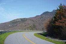
At milepost 304 was the Linn Cove Viaduct, a popular tourist destination that sticks out over the mountainside. It’s not popular, however, with bicyclists who have a fear of heights AND a fear of going over bridges. I couldn’t pedal fast enough to get through that stretch of highway.
At 6,684 feet above sea level, Mount Mitchell is the highest elevation east of the Mississippi River. I couldn’t make my trip without tackling the challenge of Mount Mitchell. But the climb from milepost 344 to 355 was nearly all uphill, and by the time I reached the end of my ride for the day, I was exhausted. After one mile up the five-mile spur to Mount Mitchell, I decided it would be best to pack it in. With about 30 minutes of daylight left, I pitched my tent and prepared to bed down.
Just before I entered my tent, however, I saw a Ford Explorer coming down the mountain. No one had passed me in the uphill direction since I began my ascent of Mount Mitchell. During my ride that day, I concluded that my best chance for dealing with the detour was to beg a ride from one of the many southbound pickup trucks or other large vehicles that passed me. Without such assistance, my ride would come to an end. Thus, I concluded that the Ford Explorer was probably my last chance of the day to rescue my ride.
I waved at the vehicle so the driver would know that I was being more than just friendly. He pulled over, and I quickly spilled out my story. I ended my story by asking him whether he was southbound. “No,” he said, “I’m headed to Ashville.” “Uh, that is southbound,” I informed my friend—David from Indiana. He explained that in the morning, he needed to test equipment at an elevation over 5,000 feet, at a temperature near 51 degrees, at various specific speeds, and on a straight and level roadway, and for those reasons, he was on Mount Mitchell. The testing, he explained, would take about four hours. If I could wait until the morning, he said he could give me a ride to the general vicinity of the airport. I assured him that I would meet him at the top of Mount Mitchell in the morning. I did not have the heart, however, to tell him that neither the Parkway nor Mount Mitchell would give him the testing conditions he needed.
[Steve Talevi, a local-government attorney who lives in Virginia’s Roanoke Valley, insists he’s not a cyclist but “a guy who likes to ride his bike every now and then.”]
Before you comment
The comments section is here to provide a platform for civil dialogue on the issues we face together as a local community. Xpress is committed to offering this platform for all voices, but when the tone of the discussion gets nasty or strays off topic, we believe many people choose not to participate. Xpress editors are determined to moderate comments to ensure a constructive interchange is maintained. All comments judged not to be in keeping with the spirit of civil discourse will be removed and repeat violators will be banned. See here for our terms of service. Thank you for being part of this effort to promote respectful discussion.