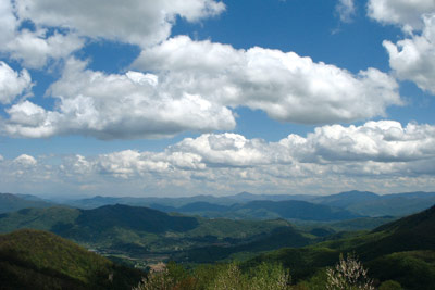
Asheville attracts lots of visitors, and a few of them land in my guestroom. They've heard of the Blue Ridge's beauty and ask me to show them the "mountains." Where I take them, however, depends on how much they're willing to walk and what shoes they've brought with them. If we have a full day, here's what I typically do.
If they don't want to walk
A drive on the Blue Ridge Parkway is always a treat. But for more than views at overlooks, I take visitors on a drive through the Pisgah National Forest on U.S. Highway 276. Starting at the forest's southern entrance — the intersection with N.C. Highway 280, just outside Brevard — we stop at the Pisgah Ranger Station and Visitor Center to pick up a free map and check out the bookstore. We walk across the road and up to an historic building where they still hold services each Sunday — the English Chapel United Methodist Church, established in 1860.

Continuing north, we visit the Pisgah Center for Wildlife Education and Fish Hatchery, once a camp for the Civilian Conservation Corps. We buy fish food and watch a true feeding frenzy in the raceways, then walk through a small native-wildflower garden.
Getting back on Highway 276, we stop at Looking Glass Falls, probably the most popular and photographed waterfall in Western North Carolina. Next stop, the historic Cradle of Forestry, site of the first American school of forestry: For children, there are scavenger hunts, a helicopter simulation, a locomotive to climb on and logging equipment.
Up on the Parkway, even the most blasé city guest is impressed by the view at milepost 411.8: "So this is the real Cold Mountain," they say. Then we head six miles further south to amaze them at milepost 417 with views of Looking Glass Rock, which gets its name from the way its ice-coated rock face glistens in the winter.
If they say they're walkers
We head out to Cataloochee Valley, the closest place from Asheville to enter the Great Smoky Mountains National Park. The valley was once home to the largest community in the park, about 1,200 people. When they had to leave, several buildings were left in place. At the information board, we pick up an auto-tour booklet which explains the Cataloochee's history.
At the end of the valley road, we walk a flat mile to the Woody House, once the home of Steve Woody, the last resident to leave Cataloochee. Visitors are always surprised that they're free to roam both floors of the open and unguarded, white frame house. Coming back, we look into the Caldwell House and barn, the two-room Beech Grove School and Palmer Chapel.
If it's dusk or raining, we may be lucky and see elk roaming the grassy fields of Cataloochee Valley. Common long ago in the Southern Appalachian mountains, elk were re-introduced to the Smokies in 2001. In the fall rutting season, bull elk come out to bugle, spar and strut as they attract their harem.
If they're hikers
We walk up to Hemphill Bald, a moderate hike (9.6 miles roundtrip with a 1,900 ft. ascent). From Polls Gap, the trail follows the spine of Cataloochee Divide on the southeastern rim of the valley. It's at the edge of the park, marked by a split-log fence.
Cataloochee Ranch, owned by the conservation-minded Alexander family, lies across the park boundary and offers log seats, a stone picnic table, and stunning southeast views into Maggie Valley and Pisgah National Forest.
If they claim they can hike like I can
I take them up Cold Mountain in the Shining Rock Wilderness (see "Chasing Cold Mountain," Aug. 2, 2006 Xpress). Because of Charles Frazer's best-selling book and the movie, Cold Mountain may be the most famous peak in the Southern Appalachians. I promise my guests outstanding views. When the movie came out, the media buzz equated climbing Cold Mountain to climbing Mount Everest. It's not.
The easiest route starts at Camp Daniel Boone on the Art Loeb Trail, but it's steep (a 3,500-foot ascent), and wilderness-area trails aren't blazed. Guided by the wand and sign at the Forest Service information board, we plod up to Deep Gap, then take the unmarked Cold Mountain Trail to the summit ridge.
There, the second of three rock outcrops is the place for lunch and offers the best views of the Narrows, the spine between Cold Mountain and Shining Rock. The third outcrop, with a survey marker on the ground, is the official summit.
Climbing Cold Mountain is an accomplishment visitors can take home with them. No matter how tired they get, my visitors have never been disappointed.
Hike leader and outdoors writer Danny Bernstein is the author of Hiking North Carolina's Blue Ridge Heritage. She can be reached at danny@hikertohiker.com.
If it's dusk or raining, we may be lucky and see elk roaming the grassy fields of Cataloochee Valley.


Before you comment
The comments section is here to provide a platform for civil dialogue on the issues we face together as a local community. Xpress is committed to offering this platform for all voices, but when the tone of the discussion gets nasty or strays off topic, we believe many people choose not to participate. Xpress editors are determined to moderate comments to ensure a constructive interchange is maintained. All comments judged not to be in keeping with the spirit of civil discourse will be removed and repeat violators will be banned. See here for our terms of service. Thank you for being part of this effort to promote respectful discussion.