


BY DANIEL PIERCE
I grew up in Buncombe County — West (“Worst”) Asheville, to be exact — and have lived here for 48 years. I’ve spent about 30 of them studying both the human and natural history of this place, and a lot of time wandering around the county and region. I hope you’ll enjoy reading about the places mentioned and plan to explore them yourself as our world opens up again.
The Swannanoa Gap
Near my home in Ridgecrest is a beautiful place that’s rich in history and serves as a primary point of entry into Western North Carolina: the Swannanoa Gap. Many visitors to Western North Carolina make the roughly 7-mile climb up the mountain on Interstate 40 from Old Fort to Ridgecrest. The top of the mountain is what most people know as Swannanoa Gap, but traditionally, the gap sits a bit to the north, just above the Ridgecrest Conference Center and pretty much at the intersection of Old U.S. 70 and Mill Creek Road. Here you can look down past a huge patch of kudzu into Royal Gorge and spot the footpath that folks have used to access this area for thousands of years.
A visit to the gap can be both fun and educational. Nearby, there are three state historical markers (denoting Stoneman’s Raid, Swannanoa Gap and the Swannanoa Tunnel) and a Civil War Trails interpretive sign commemorating the Battle of Swannanoa Gap. Hikes in the area include the family- (and even stroller-) friendly Point Lookout Greenway, the short but steep climb up Mount Kitsuma and the more challenging excursion along the Old Stagecoach Road. Most cyclists should be able to navigate the greenway, and mountain bikers with more advanced skills can tackle Mount Kitsuma and Youngs Ridge.
Early arrivals
The route was first carved out by Archaic Indians as they came up out of the Appalachian foothills and followed Swannanoa Creek up through the gap on the way to hunting and gathering opportunities in the mountains. The Cherokee used it for that purpose and also as a trading route and warpath. In the spring of 1784, the first white settler in Buncombe County, Samuel Davidson, made his way up the rough trail with his wife, their young daughter and a young enslaved female; accounts vary as to their names. Davidson settled near where the East Asheville exit on I-40 (Exit 55) is now located, but he soon met a sad fate. He was killed by the Cherokee on Jones Mountain when he went out in search of a cow or horse (again, accounts vary) and followed the sound of its bell, unaware that Cherokee warriors had taken it from the animal’s neck to lure him into an ambush. His wife fled back to McDowell County with the enslaved girl and the baby, but other settlers soon arrived.
As Buncombe County grew, the path up Swannanoa Creek was widened to accommodate drovers delivering cattle, hogs, turkeys and other livestock to markets in North Carolina’s Piedmont, and the wagons and stagecoaches bringing in new visitors and residents.
A Confederate victory
During the Civil War, Confederate troops used the route to move back and forth between the mountains and the Piedmont. In April 1865, Union Gen. Alvan Gillem tried to enter Western North Carolina through the gap but was repulsed by Confederate soldiers and volunteers led by Gen. James G. Martin. The Confederates felled trees to block the Union troops’ progress and peppered them with rifle fire from the gap, forcing them to retreat. It helped the Confederate cause that both sides knew the war was over and no one wanted to risk their life in a suicidal charge up the mountain. Although the Battle of Swannanoa Gap was a Confederate victory, it only delayed the inevitable: Gillem’s troops circled around and entered WNC through Hickory Nut Gap, taking Asheville from the south.
You can still follow part of what locals call the “Old Stagecoach Road” up from near the lower end of the Point Lookout Greenway, just above the Old Fort Picnic Area. Not far up the greenway a gated U.S. Forest Service road branches off to the left. Follow this road and you’ll see the trail paralleling Swannanoa Creek. Along the way, you encounter the graves of both a Confederate and a Union soldier — stark reminders of the battle that played out here 155 years ago. About three miles in, near the top of Swannanoa Gap, you will come to the railroad tracks. At that point you’ll need to turn back, as this area, which is the property of Norfolk Southern Corp., is posted “No Tresspassing.”
Tunnel vision

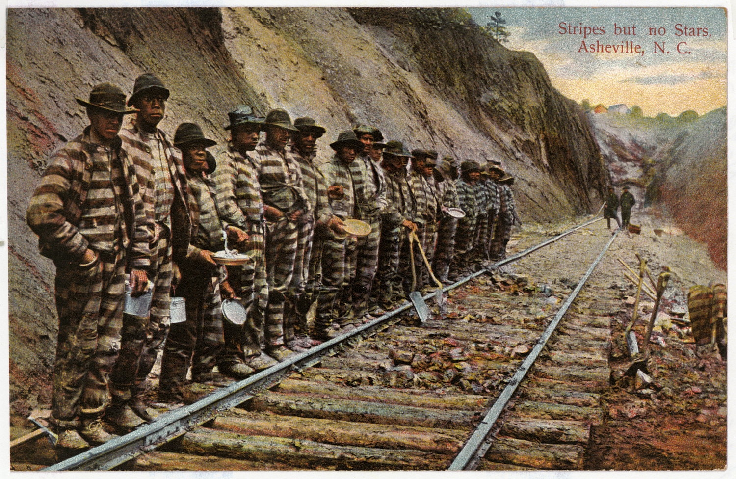
In 1879, the Old Stagecoach Road was supplanted by a new route that went under, not over, the gap. On March 11, 1879, convict laborers working from both ends linked up after a blast opened the legendary 1,832-foot-long Swannanoa Tunnel all the way through. That day, James H. Wilson, chief engineer for the Western North Carolina Railroad, telegraphed Gov. Zebulon B. Vance as follows: “Daylight entered Buncombe County this morning through the Swannanoa Tunnel.” The celebration proved short-lived, however, as a cave-in killed a reported 20 convicts, a tragic exclamation point to the hundreds who died due to accidents, disease, malnutrition and general ill treatment while working on the route up Old Fort Mountain. (See also “How Convicts Conquered the Swannanoa Grade; A Chat with Railroad Historian Steven Little,” Sept. 23, 2015, Xpress)
The building of the railroad has been memorialized in both song and story. Legendary Buncombe County “songcatcher” Bascom Lamar Lunsford, who founded the Mountain Dance and Folk Festival, recorded the song “Swannanoa Tunnel.” Sung in the mountains for years, it perhaps originated as a work song among the convict laborers. A portion of the lyric goes, “Asheville junction, Swannanoa Tunnel; All caved in, baby, all caved in.”
In The French Broad, her seminal history of the region, historian and novelist Wilma Dykeman has a chapter on the construction of the railroad and its tragic consequences. And The Road, by fellow Asheville native John Ehle, provides a classic fictional account of those events.
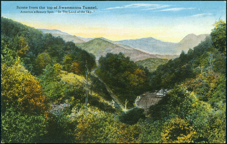
Winding up the mountain from Old Fort, the route traverses seven tunnels. Parts of it, including the Swannanoa Tunnel, are visible from the Old Stagecoach Road. You can also spy a couple of other tunnels along Old U.S. 70, the route that supplanted the railroad.
Point Lookout
In the 1920s, the state of North Carolina built Route 10 from Old Fort to the Swannanoa Gap, hugging the slopes above Swannanoa Creek and the upper part of the railroad grade. The name was changed to U.S. 70 when it became a federal highway — and the major access for people coming into WNC. One of the highlights of the route was Point Lookout; looking down into Royal Gorge, the tourist attraction featured a restaurant, gas station, gift shop and a soft-drink-swilling bear named Sally.
In the 1970s, a 3.6-mile section of the road was closed off, due to the expense of maintaining a curvy, slide-prone highway that the completion of I-40 had rendered obsolete. In 2008, local interests and McDowell County officials teamed up with the state and federal governments to turn the old road into the Point Lookout Greenway, a popular paved walking and biking trail. Point Lookout itself is about a mile down the trail and features interpretive signage and a large flagpole, one of the hallmarks of the original tourist attraction. The trail, which runs through land owned by the U.S. Forest Service and Norfolk Southern Corp., combines natural attractions with a bit of history. Those who go early in the morning or at evening time can often spot wildlife: I’ve seen bears and even a bobcat, was once chased by a hen turkey protecting her chicks as I biked up the mountain, and I almost always hear the junglelike calls of the pileated woodpecker on my walks.
Swannanoa Gap is also the launching spot for one of the most popular mountain biking/hiking trails in WNC: the Kitsuma/Youngs Ridge Trail. It’s only about a mile up a dozen or so switchbacks to the top of Kitsuma, which features great views back down the Swannanoa Valley to the west and north to the Black Mountains. The Youngs Ridge Trail picks up from there, rolling along the ridge and then descending steeply to the Old Fort Picnic Area. The last part of that 4.2-mile route is what mountain bikers call a “screamer,” so if you’re hiking this trail, keep an ear cocked for bikers roaring down the mountain.
But whichever way you choose to explore this area, have a wonderful adventure.
Awesome article. I explored the Swannanoa Gap using the article as a guide and had a great day. Thank you for illuminating the history of the area, Dan Pierce.