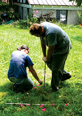
Poking around: Tasha Benyshek, left, and Jacob Turner reveal the outline of a century-old grave. photo by Cecil Bothwell
|
The pointed tip of a 5-foot metal rod is inserted in the ground while a pair of hands grips a T-shaped handle. A firm push drives the rod down a couple of feet, then abruptly down some more.
“Pink,” the supervisor says.
Her co-worker pushes the rod into another spot. “Pink,” she repeats. And another. “Pink.” The next time, the rod stops short. “Orange,” she says.
After each insertion, a piece of survey tape is poked into the resulting finger-sized hole — pink tape for spots where the rod sinks easily into the soil, orange for partial insertions, and none at all for the stabs that hit rock or firm subsoil at a shallow depth. As the tags accumulate, bits of orange tape outline a plot a little more than 6 feet long and roughly 3 feet wide.

photo by Jonathan Welch
|
Tasha Benyshek and Jacob Turner of TRC Garrow Inc., an archaeological-consulting firm, are searching for graves in the back yard at 33 Nevada Ave. in West Asheville. Asked by Xpress to help investigate the location, they are drilling into what appear to be the characteristic sinks that result from collapse of century-old pine-board coffins. While their methods are focused on subterranean evidence, circumstantial surface indications are offered in the form of plinths — slotted base stones used to hold tablets erect — and what might be a foot stone at the east end of another depression.
After a few hours on the site, Benyshek concludes that she has probably confirmed one grave. “The one we did find is the right shape and size,” she says. “I would have felt more comfortable [drawing conclusions] if we could have found others.” Some of the depressions she and Turner investigated were quite small. “It isn’t possible to rule out the possibility that they are the graves of babies,” Benyshek notes.
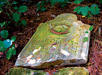
Xpress was alerted to the existence of the graves by homeowner Michael Brown. It had gradually dawned on him that his back yard was part of a cemetery, and his suspicions were confirmed when he discovered an upended tablet half buried at the back of his property.
A rubbing of the stone revealed words, some barely legible: “Martha A, wife of JJ Miller, Born 1863, Died Dec. 19, 1893.”
Then Brown learned that his neighbor, Conda Painter, two doors down, had found possible graves in her yard as well, while the yard between those two contained a built-up garden area over what might hold a continuation of a long-forgotten cemetery.
What was a cemetery doing in their back yards? Or, more to the point, how did it happen that homes, a car wash and a church parking lot all appeared to have been built on hallowed ground?
“Prophesy upon these bones”

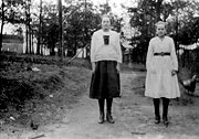
Zula and Birdie: The Andrews sisters posed for this photo in their driveway, beside what is now Nevada Avenue. The original Wilson’s Chapel is visible in the upper left. photo courtesy Pack Memorial Library and Conda Painter
|
The fate of the late Martha Miller’s remains might suggest answers. A Buncombe County deed recorded in 1888 offers a clue. The hand-written document describes the transfer of one acre of land from the estate of J.L. Henry to three trustees of a Methodist Episcopal Church.
Not long thereafter, Wilson’s Chapel was constructed near what is now the corner of Haywood Road and Virginia Avenue. The church is visible in the background of an old photograph of two sisters, Zula and Birdie Andrews, taken sometime in the early 1900s.
Wilson’s Chapel, an African-American church, conducted services at that location for nearly four decades. The parcel was mentioned in a 1924 property-line agreement among “Rufus S. Abernethy, Pastor, and Oliver S. Smith, J.C. Justice, Luther Smith, Will Greenlee, David Mitchell, Marshall Mavin, J.P. Lincoln, Trustees of Wilson’s Chapel, M.E. Church, colored parties of the first part, and A.L. Holmes, party of the second part.”
One year later, the pastor and trustees sold the church property to Eugene R. Cooke for $1,000, and the church moved to larger quarters at 103 Burton St.
Martha Ligon, a life-long member of Wilson’s Chapel until its dissolution in 1997, told Xpress that her mother had recounted stories about the church in its original Haywood Road location and the cemetery behind it. Ligon said she believed that the bodies had been transferred to Green Hill Cemetery.
A search of Pack Memorial Library records turned up Martha A. Miller (wife of J.J.) with roughly the same dates (1865-1894) buried in the Bethel Cemetery, on Dryman Mountain Road, as is her husband, who died in 1915. This suggests that at least one body was moved, perhaps at the time of J.J. Miller’s demise.
Hugh Parker, an 88-year-old Nevada Avenue resident who has lived in the neighborhood most of his life, remembers romping around the cemetery in his youth. “We used to play in the cemetery and in the abandoned church building in the late 1920s,” he recalls. “Most of the graves just had big stones laid on them, they didn’t have regular headstones. My friends and I dug a pit and put boards over the top so we could hide out and smoke cigarettes. We found bones.” Asked where his childhood fort had been located, Parker indicated it was in the general area of a West Asheville Presbyterian Church parking lot.
Parker says he thinks the cemetery was moved at some point, but Painter reported a conversation with Jesse Ray, who in 1938 founded what is now Ray & Allen Funeral Service Inc., which principally served the black community. According to Painter, “Ray said, ‘Back in those days, most families couldn’t afford to move a grave.'”
Ray is now deceased and his successor, Jesse Ray Jr., says he can shed no more light on the subject.
Meanwhile, Richard Painter, Conda’s father and a resident of Nevada Avenue for more than 40 years, recalls that the present church parking lot held a home and a garden until sometime in the 1990s. A family named Yarborough, he says, was “tilling their garden about 10 years ago and turned up a casket handle.” A local historical society, he says, identified it as an early 1800s-style handle.
His wife, Mamie Painter, recalls that the same family also plowed up “a set of homemade teeth, connected by a wire.” Laughing, she adds that “Mr. Yarborough found them and hung them on a post, and a crow snatched them up and flew off with them.”

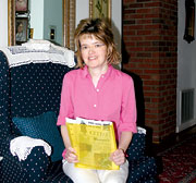
Digging into the past: Conda Painter has collected stories about the cemetery and her West Asheville neighborhood for two decades. photo by Cecil Bothwell
|
Conda Painter has interviewed numerous neighbors during the past 20 years, hoping to fill in pieces of the neighborhood’s history. Along the way, she obtained the only known photo of the original Wilson’s Chapel and compiled a file full of stories. She’s shared her findings in talks at the West Asheville Library.
Stories of an old cemetery would amount to little more than a sidelight of regional history, were it not for the adjacent Presbyterian Church parking lot. The church wants to lease that lot to Cingular Wireless for construction of a cell-phone tower. Cell towers are regulated by the federal government, which imposes strict rules regarding disturbance of antiquities, especially those which might include human remains.
Missing ink
These days, relocation of a grave leaves a paper trail. After obtaining written permission from the deceased’s next of kin, the Buncombe County Health Center issues a free permit to move the remains.
Farther back in time, the trail is much harder to follow. Deputy Registrar Ralph Fossett, who holds responsibility for Buncombe’s vital records, chuckles when asked about possible paperwork dating back almost a century. “They hardly kept records of births and deaths back then, and I’m certain there’s no record of abandoned or moved cemeteries” from that era, he says.
Wilson’s Chapel went bankrupt and folded into the French Broad Avenue United Methodist Church in 1997. That church also went bankrupt. The chapel’s records might be housed in Asheville’s district office of the UMC, but at press time, Xpress had been unable to obtain access to them.
The Old Buncombe Genealogical Society, which has compiled records on many cemeteries in the county, is currently updating its lists, but has almost no information regarding Wilson’s Chapel.
The North Carolina Office of State Archaeology keeps track of historic cemeteries, but similarly has no record of the original Wilson’s Chapel site. Assistant State Archaeologist Linda Hall, of the state’s Archives and History Western Office in Asheville, says that “normally, cell towers come through our office for review, because they are regulated by the federal government.” Hall said such projects are required to assess sites for possible archaeological significance.
In fact, when Hall contacted the state office in Raleigh following the Xpress inquiry, she learned that the proposed cell tower had been sent in for review and that Cingular had been informed that there were no archaeological sites listed there. However, following Benyshek’s investigation, Hall said that new steps are in the works. “A letter is being sent from our department to the applicant, which reads in part, ‘It has since come to our attention that the project area is at the location of a cemetery associated with the former Wilson’s Chapel. Cemeteries, marked and unmarked human burials and skeletal remains are provided legal protection under NCGS 14-148 and NCGS 14-149.'”
Rev. Willis Gaines, of the West Asheville Presbyterian Church, says that the church hopes that a Cingular lease would provide badly needed money for church maintenance. “The cemetery question seems to be news to all of us at this time,” he says.
Laurie Parker, a spokesperson for Cingular Wireless, says that “Cingular works very closely with all relevant city, county and state agencies in choosing locations for new cell sites. Should this proposed site location be determined to be of archeological or historic value, we would certainly adapt our plans for the new cell site accordingly.”


Before you comment
The comments section is here to provide a platform for civil dialogue on the issues we face together as a local community. Xpress is committed to offering this platform for all voices, but when the tone of the discussion gets nasty or strays off topic, we believe many people choose not to participate. Xpress editors are determined to moderate comments to ensure a constructive interchange is maintained. All comments judged not to be in keeping with the spirit of civil discourse will be removed and repeat violators will be banned. See here for our terms of service. Thank you for being part of this effort to promote respectful discussion.