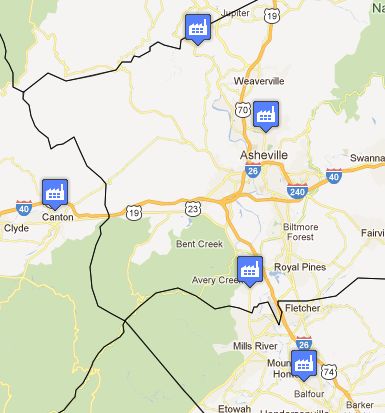
Want to know how much carbon dioxide your local power plant or landfill emit? A new EPA tool maps the info for the highest sources of greenhouse gas emissions, including five sources near Asheville.
The new interactive map lets users zoom in on major pollution sources almost anywhere in the United States. Near Asheville, there are five — the Progress Energy power plant in Arden, two Buncombe County landfills, the Henderson County landfill and the Blue Ridge Paper Plant in Canton. Click here to view the local map.
For more about the new tool, read the EPA’s press release here.
To view a recent New York Times article about the tool and its implications, click here. According to the Times article (“EPA Unveils Map of Major Greenhouse Gas Producers”), “Power plants are responsible for 72.3 percent of reported emissions and that the three largest single sources — two generating stations in Georgia and one in Alabama — are owned by the Southern Company, based in Atlanta.”


“Landfills, power plant among five top greenhouse-gas emitters near Asheville”
So?!
……………
Note to Moderatoes: this is where the conversation became incomprehensible.
Actually, the list recently released by EPA covers only the worst offenders among the so-called “point sources” of these pollutants. If it included all sources, including the little moving targets known as “non-point sources,” the list of the top five would include our motor vehicles. Data from the WNC Regional Air Quality Agency show that motor vehicles are number two in the region for emitting the greenhouse gases nitrous oxide and sulfur dioxide.