


The National Park Service has a problem unique within the federal government. For other agencies, funding is the only practical limit to growth: The National Institutes of Health can always hire more doctors, the Army build more tanks and the Department of Energy enforce regulations ever more strictly. But when it comes to parks, in the words of Blue Ridge Parkway Foundation CEO Carolyn Ward, “It’s like my daddy always said — they’re not making more land.”
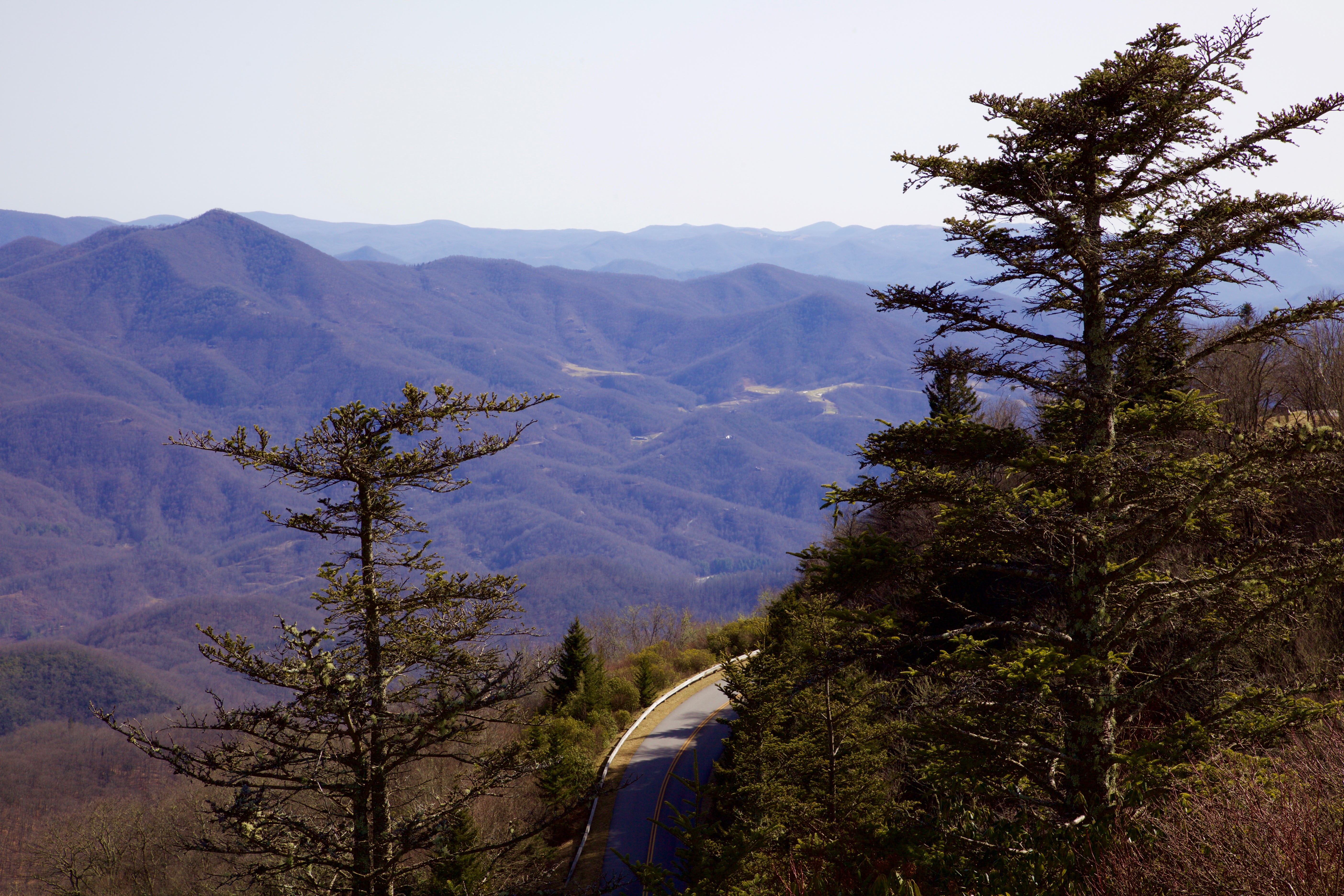
They’re definitely not making another Waterrock Knob. The highest peak in the Plott Balsam Mountains, located roughly 15 miles west of Waynesville, boasts a pristine spruce-fir forest ecosystem, home to the endangered Carolina northern flying squirrel and several rare salamanders. The area is also the source of Maggie Valley’s drinking water and holds deep cultural significance for both the native Cherokee and Appalachian settlers.
The Blue Ridge Parkway will now conserve this irreplaceable landscape thanks to recent land and financial gifts by a network of conservation groups and private donors. At 5,329 total acres, the combined area of the Waterrock Knob expansion marks the largest addition to the parkway in 60 years. “It’s really exciting when you have an opportunity like this to add to a national park,” says Ward. “My grandkids and your grandkids will get to go there one day, and that would not be the case without the kind of protection afforded by the NPS.”
Waterrock Knob also presents an opportunity for Blue Ridge Parkway officials to attempt a new kind of planning process. Through collaborative visioning with key stakeholders and the public, the park is creating a strategy for the region that considers not only the new expansion, but also the complex patchwork of public and private lands that border the parkway.
Puzzle pieces
The expansion itself comprises multiple nonadjacent parcels of land, conserved in pieces by different environmental groups before being pledged to the Blue Ridge Parkway in 2016. The Conservation Fund contributed the largest total area, 2,986 acres in the northeast part of the addition, adjacent to the Maggie Valley watershed. The Nature Conservancy gave 1,654 acres to the southwest bordering Pisgah National Forest, while the Conservation Trust for North Carolina and Southern Appalachian Highlands Conservancy provided 370 and 319 acres, respectively.
Ward explains that Waterrock Knob’s geography and location discouraged development in the area, which allowed these large tracts of land to be assembled over time. “It’s very steep and difficult terrain to access, and before the Blue Ridge Parkway, it was pretty remote,” she says. “Logging or building houses there would have been enormously expensive, so the land ended up being de facto protected.”
Funding for the project derives from a diverse collection of sources as well. The federal Land and Water Conservation Fund provided $2.6 million for land, which was paired with $5.5 million in private money, including substantial contributions from the Stanback family. The planning process is financially supported by the Blue Ridge National Heritage Area Partnership, the Pigeon River Fund at the Community Foundation of Western North Carolina and the Blue Ridge Parkway Foundation.
Leesa Brandon, a spokesperson for the Blue Ridge Parkway, points out that this collaborative approach to conservation has long existed informally along the 469-mile-long route. “With a lot of the views that people have enjoyed for years from the parkway, what they’re looking at may or may not actually be park land,” she says. The park was designed as a long and narrow corridor, drawing much of its appeal from overlooks of property under private ownership or nonprofit land trusts.
Come together

With the Waterrock Knob expansion, parkway staff wanted to engage these regional stakeholders in a more structured process. Last fall, the Blue Ridge Parkway Foundation invited key landowners and community interest groups to a workshop in Waynesville, where they began hashing out a shared landscape-scale vision.
“The NPS has a long history of knowing how to plan for our land, but thanks to the generosity of outside funders, we had the opportunity to take this beyond just the park service,” says Brandon. “We wanted to think more regionally — the squirrels and snakes don’t know where our boundary lines are.”
The parkway group hired Equinox Environmental, a conservation and sustainability consulting firm based in Asheville, to help lead the effort. Through structured conversations and cataloguing of priorities, the consultancy assisted participants such as the Rocky Mountain Elk Foundation and the Eastern Band of Cherokee Indians in reaching an inclusive proposal for the area.
Kimberly Williams, an environmental and recreation planner with Equinox, says that her group’s approach helps resolve any conflicts between stakeholders before they pose a major issue to a project. “All of these partners are working in a concentrated landscape, so we want to understand their overlaps and needs while building capacity,” she says. “It helps to have an impartial listener; we don’t have skin in the game.”
That philosophy of measured listening, says Ward, was successful at bringing together the many different perspectives represented at the Waynesville meeting. “Some people had specific interested in certain activities, and those were expressed early on,” she recalls. “But as that meeting evolved, it was exciting to watch all those disparate interest groups come together in the recognition that Waterrock Knob is indeed a special place.”
Widening the lens
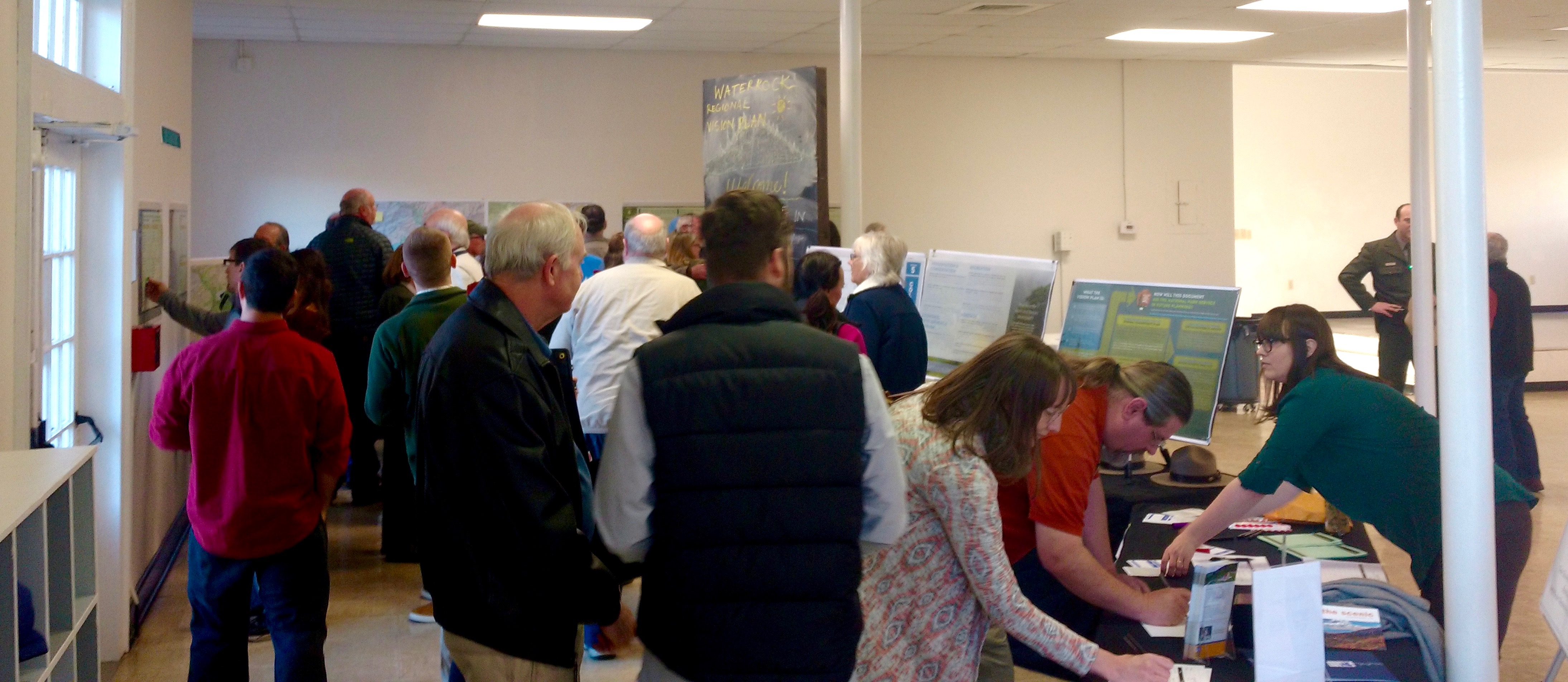
The public got its first look at the results from the fall workshop through an open forum on Jan. 25 at the Folkmoot Friendship Center in Waynesville. Approximately 50 people were on hand to express their opinions and hear from NPS staff.
Instead of a traditional town hall with official speakers and a question-and-answer period, the meeting took the form of a collaborative brainstorming session. Equinox presented the top stakeholder themes on large posters, and members of the public were encouraged to highlight their own priorities by placing colored dot stickers next to their favorite items. More specific comments were also collected using sticky notes and a suggestion box.
Incoming Blue Ridge Parkway Superintendent J.D. Lee was pleased by the turnout, pointing to the thoughtful discussions breaking out between NPS staff and the public around the different posters. “They say it takes a village to raise a child, but it also takes communities to raise a parkway,” he said. “Communication and involvement with the public are crucial, because we understand that we can’t do this alone.”
Those in attendance expressed a strong priority for preservation, as indicated by the rainbow of dots peppering the theme’s poster. Protection of threatened natural communities, drinking water supplies and the rare spruce-fir forest attracted the greatest interest, along with collaborative efforts to control invasive species. Attendees were less enthusiastic about the themes of economic development and tourism, while education and recreation fell somewhere in between.
Asheville resident Danny Bernstein, a hike leader for the Carolina Mountain Club, placed several of her dots on the recreation poster to highlight the need for a balance of frontcountry and backcountry experiences in the park expansion. Noting that a new piece of the Mountains-to-Sea Trail was completed in the Waterrock Knob area in 2016, she said that the park could lead efforts to make that trail friendlier to thru-hikers.
“There aren’t shelters and campgrounds on the Mountains-to-Sea trail for people to hike it the same way they hike the Appalachian Trail,” Bernstein said. “Logistically, it’s very difficult to do legally, and the logistical nightmare starts when you hit the parkway.”
Next steps
The feedback from the Waynesville open forum will help parkway staff and Equinox consultants further refine the collaborative vision plan. Additional comments will also be accepted through the NPS’s Planning, Environment & Public Comment website through Feb. 25. “We’re here to listen and process what’s being told to us so the plan is developed by both stakeholders and the public,” says Williams. Once the plan is finalized, the parkway will begin establishing more concrete arrangements for implementation and stakeholder partnerships.
Throughout the entire process, parkway staff and the Blue Ridge Parkway Foundation hope to maintain the spirit of collaboration on display at the Waynesville event. “There are a lot of local and regional partners with a vested stake in the future of the Waterrock Knob region, not just for NPS lands but adjacent lands as well,” says Ward. “This planning process gives us the chance to talk with the public about how to use the land lightly.”
Before you comment
The comments section is here to provide a platform for civil dialogue on the issues we face together as a local community. Xpress is committed to offering this platform for all voices, but when the tone of the discussion gets nasty or strays off topic, we believe many people choose not to participate. Xpress editors are determined to moderate comments to ensure a constructive interchange is maintained. All comments judged not to be in keeping with the spirit of civil discourse will be removed and repeat violators will be banned. See here for our terms of service. Thank you for being part of this effort to promote respectful discussion.