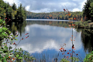
In December, the woods can be dark and bare. Leaves are sparse and wildflowers long gone, but with the rain we've had this year, the all-season waterfalls in DuPont State Forest are flowing spectacularly.

Located near Hendersonville and Brevard, the 10,400 acre forest offers almost 100 miles of well-marked trails. Its relaltively low elevation — between 2,200 and 3,600 feet — means you can enjoy the forest when the Blue Ridge Parkway is closed and the mountains are snow-covered. The land hosts varied habitats, including oak and cove forests, granite domes and mountain bogs, but it's the waterfalls that draw visitors. A few years ago, they were at the center of a controversy.
A little history
DuPont State Forest isn't pristine wilderness. Within its boundaries, you can walk two cemeteries left by long-ago inhabitants. More recently, in 1958, the international company DuPont opened a plant in the center of the tract: The company made medical X-ray films and created a private corporate retreat with picnic shelters, barbecue pits and wide dirt roads. Visitors from other DuPont locations were taken on lunchtime picnics that offered a view of High Falls. Later DuPont bought an adjacent private facility, Camp Summit, which added Lake Julia and an airstrip with a view of Mount Pisgah to the property.
DuPont shuttered its plant operations in 1996, selling most of the land to the state, but the plant and surrounding 2,200 acres went to Sterling Diagnostic Imaging. Three years later, Sterling sold the plant property to Agfa. The remaining land, which included the waterfall tract, was bought by a housing developer who planned a gated community. More than a year of controversy ensued, with the developer going ahead with building projects. Some of those buildings still stand near Lake Julia. The public pressured then Gov. Jim Hunt to acquire the land by eminent domain. In the end, North Carolina paid the developer nearly $25 million. In December 2000, the waterfall tract was opened to the public.
Waterfalls
The trails to the four best-known waterfalls in DuPont — Hooker, High, Triple and Bridal Veil, all on the Little River — attract many walkers (and Hollywood, too: The 1992 film The Last of the Mohicans featured the latter two cascades). Hooker, which can be seen from a handicapped-accessible overlook, is wide and impressive. In the summer, visitors cool off in the pools below the falls. High Falls cascades down a 150 feet of rock, and Triple Falls covers a similar distance but in three distinct cataracts. A new staircase, built by Western Piedmont Community College, takes you out onto rocks between the second and third levels. Bridal Veil Falls is a short drop but as beautiful as its name implies. There are two other waterfalls in DuPont too: Grassy Creek and Wintergreen.
But after visiting these falls, you've seen only a small part of the forest.
Something for everyone
DuPont is truly a multi-use playground — hikers will meet bikers and equestrians on most trails.
Mountain bikers love the park's wide trails. Jim Parham, author of the Off The Beaten Track series and co-owner of Milestone Press in Almond, N.C., says, "Most trails are appropriate for beginner to intermediate bikers, although advanced riders will find plenty to test their skills." For novices, Parham recommends riding to Bridal Veil Falls from the Buck Forest trailhead via dirt roads. He sends more experienced mountain bikers over bare, rocky trails on Cedar Rock, out the Corn Mills Shoals Trail and over Burnt Mountain. The Ridgeline Trail has great whoop-it-up, hoot-and-holler downhill sections.
Brevard resident Betsy Craig founded a fishing camp for teenagers that's sponsored by Trout Unlimited. "The Little River [in DuPont] is a lovely place to fish and well-stocked with rainbow, brown and brook trout, with flat stretches on the way to Triple Falls," she notes.
For paddlers, Hendersonville's Lee Belknap — a former American Whitewater board member and safety chairman — rates the difficulty of the runs between class III and V, depending on the water level and what part is being run. "At appropriate water levels, the river below Triple Falls is excellent for advanced kayakers," he reports.
The easy, rolling trails also attract geocachers, who practice a high-tech version of the old-fashioned treasure hunt. Caches are set up all over the world, and their locations are recorded on the Web. GPS users apply the coordinates to find the caches.
But DuPont is our own hidden treasure, well worth winter exploration.
All six waterfalls are featured in a newly released map that's complete with GPS coordinates: Waterfalls of North Carolina by the Black Mountain-based Outdoor Paths Publishing. Of the 301 falls noted on the map, all of DuPont's make the top 50 for beauty.
[Hike leader and outdoors writer Danny Bernstein is the author of Hiking North Carolina's Blue Ridge Heritage. She can be reached at danny@hikertohiker.com.]


Before you comment
The comments section is here to provide a platform for civil dialogue on the issues we face together as a local community. Xpress is committed to offering this platform for all voices, but when the tone of the discussion gets nasty or strays off topic, we believe many people choose not to participate. Xpress editors are determined to moderate comments to ensure a constructive interchange is maintained. All comments judged not to be in keeping with the spirit of civil discourse will be removed and repeat violators will be banned. See here for our terms of service. Thank you for being part of this effort to promote respectful discussion.