All images courtesy of the N.C. Department of Transportation
As local leaders wrestle with different ideas about which route is best for an Interstate 26 connector near downtown Asheville, the N.C. Department of Transportation has put together a series of maps and charts to help inform the public about the options.
On March 18, N.C. DOT Construction Engineer Ricky Tipton presented the following maps and charts to the Buncombe County Board of Commissioners, which voted unanimously to recommend that the transportation agency move forward with a route called “Alternative 3C.” As you can see in the map below, the route involves constructing the interstate across the French Broad River to the northwest of Westgate Shopping Center:
That route is a new variation from an older plan called “Alternative 3,” which Tipton says would be more disruptive to the Emma neighborhood in West Asheville. View that route here:
The map below shows both of these routes side by side. On the left is the older “Alternative 3” route; on the right is the newer “Alternative 3C” route that the commissioners supported.
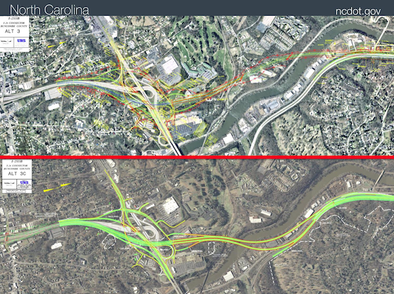
Here’s another look at the two routes side by side. On top is the older “Alternative 3” plan. Below is the “Alternative 3C” route commissioners want the N.C. DOT to pursue, which parallels Riverside Drive further south before crossing the French Broad.
Meanwhile, the Asheville Design Center, a nonprofit that’s been analyzing various I-26 plans since 2007, has been lobbying for very different routes. In a statement released to local media March 18, the center says routes called “Alternative 4” and “Alternative 4B” would “provide safer movements that remove interstate traffic from the Bowen Bridges.”
Here’s maps of the center’s preferred routing:
“Alternative 4”
“Alternative 4B”
One of the main arguments advocates are making for supporting the “Alternative 3C” plan is that it’s less expensive than the other options currently under consideration. Later this year, the N.C. DOT will evaluate which interstate projects to fund across the state, largely based on how expensive they are. This chart shows the different routes and there estimated costs:
Another argument advocates are making for “Alternative 3C” is that it will require less relocations than other plans. The chart below shows how many residencies and businesses would need to be removed to make way for each of the routes.
All of the above plans currently being considered by local officials involve only one section of what the N.C. DOT eventually hopes to build to complete a comprehensive I-26 connector. The various routes above are all limited to “Section B” of the entire project, which encompasses the area northwest of downtown and the Patton Avenue crossing. Possible routing for sections “A” and “C” are not part of the expense estimates or recommendations being considered by local government at this time.
Residents will have an opportunity to weigh in on the different I-26 proposals next week. Asheville City Council, which is considering signing off on the county resolution to support the “Alternative 3C” plan, will hold a March 25 public hearing on the issue.
The DOT is in the process of organizing a public hearing in early May, although a specific date has not been set yet.


Before you comment
The comments section is here to provide a platform for civil dialogue on the issues we face together as a local community. Xpress is committed to offering this platform for all voices, but when the tone of the discussion gets nasty or strays off topic, we believe many people choose not to participate. Xpress editors are determined to moderate comments to ensure a constructive interchange is maintained. All comments judged not to be in keeping with the spirit of civil discourse will be removed and repeat violators will be banned. See here for our terms of service. Thank you for being part of this effort to promote respectful discussion.