

From the Institute for Climate Education at A-B Tech: Winter can bring all kinds of challenges to the mountains —from cold and windy conditions like we’ve seen today to the threat for wintry weather. And, while snow can bring an almost festive vibe to our area, the threat of freezing rain or sleet is a whole other story.
One of the most important factors in forecasting winter weather is that of precip type (precipitation type). Precipitation is defined as water in a liquid, frozen, or freezing form that falls from clouds under the influence of gravity to Earth’s surface. When a meteorologist talks about “precip” as opposed to just calling it rain, they are usually talking about more than one specific type — for example, large thunderstorms create more than just rain; they create several forms of precipitation, including rain and hail.
During winter, the challenge for forecasting weather is often associated with forecasting the precip type that can be expected. Such is the case with the storm expected to impact our area on Friday, Jan. 25. While is looks like most areas will experience some precip, the type will vary depending on where you are located and you will likely see different types during the event because the temperature profile in the atmosphere will change.
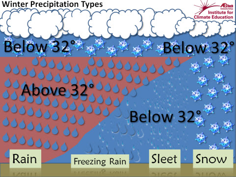
What we get depends on the temperature of the air that it falls through. Take a look at the graphic below. On the far right, the precipitation starts as snow, and stays frozen as snow all the way to the ground because the air is below freezing, and stays that way through the entire column of air that the snow passes through. As you move to the left in the image,you can see that there is a layer of warm air that intrudes into the cold air. That warm air can melt the snow, turning it into liquid. If the liquid drop passes into air that is below freezing again, it falls as sleet, or freezing rain, depending on how much time it has to re-freeze.
The National Weather Service has just issued a Winter Weather Advisory for Asheville and all of Western North Carolina. Much of our region will see freezing rain, sleet or snow beginning tomorrow.
Freezing rain can cause numerous issues, from making travel dangerous, to weighing down power lines and trees. Sleet can cause problems on roads as well. Be sure and stay alert to changing weather conditions and changing temperatures tomorrow and be safe!
Before you comment
The comments section is here to provide a platform for civil dialogue on the issues we face together as a local community. Xpress is committed to offering this platform for all voices, but when the tone of the discussion gets nasty or strays off topic, we believe many people choose not to participate. Xpress editors are determined to moderate comments to ensure a constructive interchange is maintained. All comments judged not to be in keeping with the spirit of civil discourse will be removed and repeat violators will be banned. See here for our terms of service. Thank you for being part of this effort to promote respectful discussion.