From the Institute for Climate Education at A-B Tech: No doubt about it, late winter and early spring in Western North Carolina have been cooler and wetter than we normally expect. But it looks like the coming weekend should bring some much needed sunshine and a return to near normal temperatures.
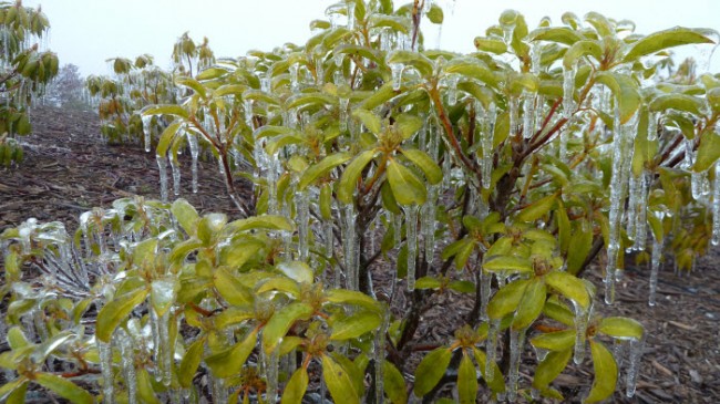
Through much of this week, winter seemed to hang on with a chill in the air, even producing rain, sleet and a few slushy snow showers on Thursday. And, almost as if to give a parting shot, we received a dose of freezing rain in some of the higher elevations that coated everything with a layer of ice, as you can see in the image below of the beleaguered mountain laurel and rhododendrons in my yard.

This fir tree had icicles up to 4 inches long hanging off of its branches. Notice how the entire structure of the branch is encased in ice.

The good news is that the skies cleared Friday April 5, and the April sun will have a chance to warm things up as we head into the weekend. You can see the clouds clearing on the Institute’s HD webcam here.
We should enjoy warmer and drier conditions in the short term because the next large storm system is not expected until the middle to late part of next week. That system will likely bring some colder air with it. So, don’t forget that there’s still plenty of cold air over Northern Canada that can cause frost and freeze into late April and early May. In other words, don’t put the winter clothes away just yet!
An additional reminder as we look forward to next week, warmer air also brings the potential for thunderstorms. This next system may bring the risk for thunderstorms as that warmer air clashes with a cold front. We’ll know more as we get closer to the event.
SkyWarn 2013 – Saturday April 13, 2013
Do you want to learn more about severe weather? What causes it. How it forms. What you can do to protect yourself, your family, your co-workers? And, how to report it to the National Weather Service.
Join us for a free severe weather workshop on Saturday, April 13, at A-B Tech. The event is open to anyone who wants to attend, but pre-registration is required. You’ll find more information and super simple registration here.


Before you comment
The comments section is here to provide a platform for civil dialogue on the issues we face together as a local community. Xpress is committed to offering this platform for all voices, but when the tone of the discussion gets nasty or strays off topic, we believe many people choose not to participate. Xpress editors are determined to moderate comments to ensure a constructive interchange is maintained. All comments judged not to be in keeping with the spirit of civil discourse will be removed and repeat violators will be banned. See here for our terms of service. Thank you for being part of this effort to promote respectful discussion.