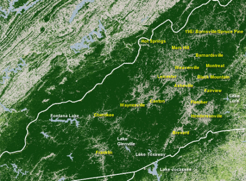
Pamela McCown from AB-Tech’s Institute for Climate Education sent us this cool graphic, which uses NASA satellite data to show forest cover in green over Western North Carolina. McCown says:
“For the first time ever, researchers now have a detailed view of the forests across the lower 48 states. Taking 6 years to complete, the National Biomass and Carbon Dataset project mapped our nation’s forests at the highest resolution ever (30 meters), providing baseline information about tree height, forest structure and carbon storage capability in the year 2000.
“It’s believed that as much as 45 percent of the carbon stored on land is tied up in trees. Western North Carolina’s unique climate has produced amazing biodiversity across our region and our important role in the Earth’s carbon cycle is evident in the dark green colors on the map above. The map depicts the concentration of biomass— a measure of the amount of organic carbon—stored in the trunks, limbs, and leaves of trees. The darkest greens reveal the areas with the densest, tallest, and most robust forest growth.
“And while it’s interesting to see the important role that our forests play in the role of carbon storage – it’s the detail of the new maps that will leave you stunned.”
The image is an up-close look at Western North Carolina/Eastern Tennessee taken from a larger national map, McCown explains. “Heavily forested areas are dark green, lakes are light blue, and areas with less trees are lighter in color. Can you make out the major population centers in the region?” she continues. “If you look carefully, you can even see the corridors formed by major roadways such as I-40 through Buncombe County and Highway 19 through Madison and Yancey Counties.”
McCown credits NASA Earth Observatory mapper Robert Simmon, who used multiple data sets compiled and analyzed at the Woods Hole Research Center in Massachusetts. You can find NASA’s story on the project here.
Want to study this stuff in greater detail? Check out the classes offered by the Institute for Climate Education, including those explaining how the weather and climate of Western North Carolina have helped to create our region’s amazing biodiversity.


Before you comment
The comments section is here to provide a platform for civil dialogue on the issues we face together as a local community. Xpress is committed to offering this platform for all voices, but when the tone of the discussion gets nasty or strays off topic, we believe many people choose not to participate. Xpress editors are determined to moderate comments to ensure a constructive interchange is maintained. All comments judged not to be in keeping with the spirit of civil discourse will be removed and repeat violators will be banned. See here for our terms of service. Thank you for being part of this effort to promote respectful discussion.