


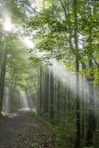
When Enka retiree Carroll Koepplinger wants to see spring wildflowers, he knows where to go.
He makes a pilgrimage up a faint trail that parallels Hawkbill Creek in a lesser-known corner of the Craggy Mountains that’s part of Pisgah National Forest. He has led several Carolina Mountain Club hikes through the valley and its north-facing hardwood forest over the past six years.
“One time we counted over 60 different wildflowers,” Koepplinger says. “It’s a beautiful, beautiful area.”
In a few years, people following in Koepplinger’s footsteps might be traveling through a national scenic area, with restrictions designed to protect the biological diversity of publicly owned land in the Hawkbill Creek valley and much of the rest of the Craggy Mountains.
Or they might find that many of the trees in the steep valley have been cut and hauled off to a sawmill.
The pending approval of a U.S. Forest Service plan for the roughly 1 million acres that the Nantahala and Pisgah national forests cover in Western North Carolina is likely to influence whether a large swath of the Craggies should be open for timber harvesting or managed for recreation. The plan, released in January, is consistent with the idea of a national scenic area, which would require additional action by Congress.
But backers of an NSA say the Forest Service proposal does not protect all of the land they believe should be included. The plan would allow logging on Hawkbill Creek and three other areas that NSA supporters want to be a part of a scenic area.
The NSA could include as much as 16,000 acres of USFS land that runs north from the upper Shope Creek valley in the Riceville area to the land around Cane River Gap and Ogle Meadows in Buncombe County’s northeastern corner. Anyone who has looked north from the Craggy Gardens Visitor Center, the nearby picnic area or the top of heavily visited Craggy Pinnacle — spots in the protected Blue Ridge Parkway corridor northeast of Asheville — has gotten a bird’s-eye view of most of the land in question.
Most of the area where advocates want an NSA, commonly called Big Ivy or the Coleman Boundary, is accessible by foot from the Blue Ridge Parkway or by trails and gravel roads that lead up from the Barnardsville area. (Shope Creek and a patch of Forest Service land nearby on the headwaters of Ox Creek are separate parcels 2 miles away and closer to Asheville.)
Big Ivy’s trails and roads are popular with equestrians, hikers and mountain bikers from many places. Locals also hunt, fish and pick ramps on the land, says Hannah Furgiuele, a Barnardsville resident and organizer of the community effort backing NSA status.
“It’s so close to Asheville, it attracts so many people,” she says. Because Big Ivy is “a highly visible place” from the parkway, “a lot of people have a vested interest in it, even if it’s not from living directly here.”
“Hunters and hippies”
The proposed Forest Service plan calls for wilderness designation for 3,222 acres, including the popular Douglas Falls and land mostly to the north, west and south of the falls. Special rules would prevent logging while encouraging recreation on 8,279 more acres of Pisgah National Forest that lie mostly to the north of the proposed wilderness. A final plan is expected to be approved later this year, although the possibility of subsequent litigation not directly related to the Craggies could delay its taking effect.
Motorized equipment and logging would be prohibited in the wilderness area, but hunting, hiking and fishing would be allowed. On the 8,279 acres under special rules, timber cutting would still be off-limits, but the list of allowed activities would expand to include mountain biking, horseback riding and driving on the main Forest Service roads.
So far, the Forest Service proposal and a campaign by Barnardsville-area residents to prohibit logging on Forest Service land in the Craggies has received little opposition. Will Harlan, a leader of the community effort and a senior biologist for the Center for Biological Diversity, says local “hunters and hippies” back the idea. He believes the way the Forest Service proposes to manage the Craggy Mountains area sets the table for congressional approval of an NSA.
National scenic area designation comes with fewer hard-and-fast rules than does a national park or national recreation area. Harlan says there are only 10 in the country. Advocates have latched onto the idea for the Craggy land because it would provide flexibility to continue existing recreational uses and make the logging ban a matter of law, not subject to a change in Forest Service policy. They hope NSA status will also give the area an advantage when federal funds for road or trail maintenance and other needs are divided up.
The Forest Service plan for the Nantahala and Pisgah does not take a position for or against an NSA in the Craggies, leaving that decision to Congress. Broad direction for the NSA would come from the establishing legislation.
Harlan says advocates have been in touch with the offices of North Carolina’s two U.S. senators, Republicans Richard Burr and Thom Tillis, and staffers for both “have shown significant interest.” Mountain Xpress requests for comment sent to the senators’ offices elicited no responses.
Luke Ball, spokesman for 11th District U.S. Rep. Madison Cawthorn, says the Republican and his staff are learning more about the forest plan and the NSA proposal but Cawthorn “is not taking an official stance as of yet.”
In or out
While the idea of an NSA hasn’t been very controversial, there is a debate over whether timber harvesting should be allowed on parts of the Forest Service’s land in the Craggies, which could make them unsuitable for an NSA. Harlan says the Forest Service erred by proposing designations in the forest plan that would allow logging for the Hawkbill Creek drainage, other Pisgah land north of N.C. 197 and the Shope Creek and Ox Creek parcels. Restrictions would be imposed on parts of those drainages closest to the Blue Ridge Parkway to protect views from the road, but a range of uses, including logging, would be allowed in the rest.
Harlan says backers of the NSA will push to include those areas among the territory where logging is banned. The Forest Service’s move “seems very inconsistent with what the public and community leaders are asking for,” he says.
Michelle Aldridge, the local Forest Service official in charge of writing the Nantahala-Pisgah plan, says the fact that logging would be allowed in those areas doesn’t guarantee they will be cut. Any timber cutting would happen after extensive analysis to identify sensitive areas and steps to protect them, she says.
Aldridge says logging creates a mix of forest types and ages that’s better for wildlife and the forest overall. “We’re not harvesting timber at random. We’re thoughtfully restoring ecosystems,” she says. Places in the Craggies where logging would be allowed are “not the core area that’s visible” from the Blue Ridge Parkway, she continues.
Josh Kelly, public lands field biologist for Asheville-based environmental nonprofit MountainTrue, says parts of the valley and some land around N.C. 197 were most recently logged from 1989-92 and part of Shope Creek in 2010. He believes someone in the Forest Service wants to cut trees in the Hawkbill Creek valley and beside N.C. 197 again.
He’s opposed. “Each have exceptional old-growth forests,” Kelly says of those tracts. “They are just as beautiful and scenic as the rest of the area. To me, they all belong together.”
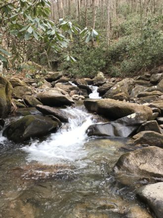
A reporter who roamed the Hawkbill Creek valley in mid-February found none of Koepplinger’s wildflowers — it was too early for that, alas. But there were boulder fields covered with moss, gnarled trees close to the ridgeline, plenty of clear water in the creek and in the lower two-thirds of the valley, closed logging roads and patches of young trees interspersed with larger areas of older woods.
Consensus amid controversy
WNC residents, the Forest Service, environmentalists, timber groups, hunters and others have debated how much timber should be cut from the Nantahala and Pisgah forests since at least the 1970s. MountainTrue’s predecessor organization, the WNC Alliance, used an aerial photo of several clear-cuts in the northernmost part of Big Ivy to rally support for less logging in 1989, when the forest plan now in effect was being written. A bill to designate 2,380 acres in the Craggies as wilderness passed the U.S. House in 1990 but did not come up for a vote in the Senate.
Protections for Craggy could get caught up in hostility from several of WNC’s more rural counties to wilderness designation in general, as well as debate over planned logging, whenever the issue reaches Congress. The plan recommends adding more than 49,000 acres to the 66,000 of official wilderness areas now on the Nantahala and Pisgah and increasing annual timber cutting from 650 acres to 1,200 acres, or as much as 3,200 acres if the Forest Service got a major budget increase.
Tillis and individual commissioners in some WNC counties, including Haywood, Transylvania, Macon and Graham, in 2016 backed giving counties veto power over Forest Service moves to manage some areas as wilderness. Environmentalists have pushed back, arguing that the forests belong to all Americans, not just those in the 18 WNC counties that contain the Pisgah and Nantahala.
However, support for more local control may boost the push for an NSA in the Craggies. The Buncombe County Board of Commissioners, at the time split 4-3 between Democrats and Republicans, unanimously approved a resolution in April 2020 endorsing the national scenic area proposal.
The N.C. Forestry Association, a timber industry group that backs more logging on national forests in WNC, neither supported nor opposed an NSA in the Craggy Mountains in its comments on the Nantahala-Pisgah plan, Executive Director John Hatcher notes.
Many hunting groups favor more timber cutting because the young forests that follow provide habitat for deer, grouse and other animals. But David Whitmire, a Transylvania County resident who leads a sportsmen’s group called the Fish and Wildlife Conservation Council that has been heavily involved in the forest plan debate, said the group would be unlikely to oppose Buncombe commissioners if they continue to back an NSA. “They’re the elected officials there,” he said.
Before you comment
The comments section is here to provide a platform for civil dialogue on the issues we face together as a local community. Xpress is committed to offering this platform for all voices, but when the tone of the discussion gets nasty or strays off topic, we believe many people choose not to participate. Xpress editors are determined to moderate comments to ensure a constructive interchange is maintained. All comments judged not to be in keeping with the spirit of civil discourse will be removed and repeat violators will be banned. See here for our terms of service. Thank you for being part of this effort to promote respectful discussion.