BY BLAKE ESSELSTYN
Here’s a question that may seem simple, though the answer is anything but: Where is Asheville?
I’ll bet most locals, if given a map showing just streets and street names, could place a dot on the center of town — a point like the Vance Monument or City Hall. But how many could come close to drawing the outlines of Asheville?
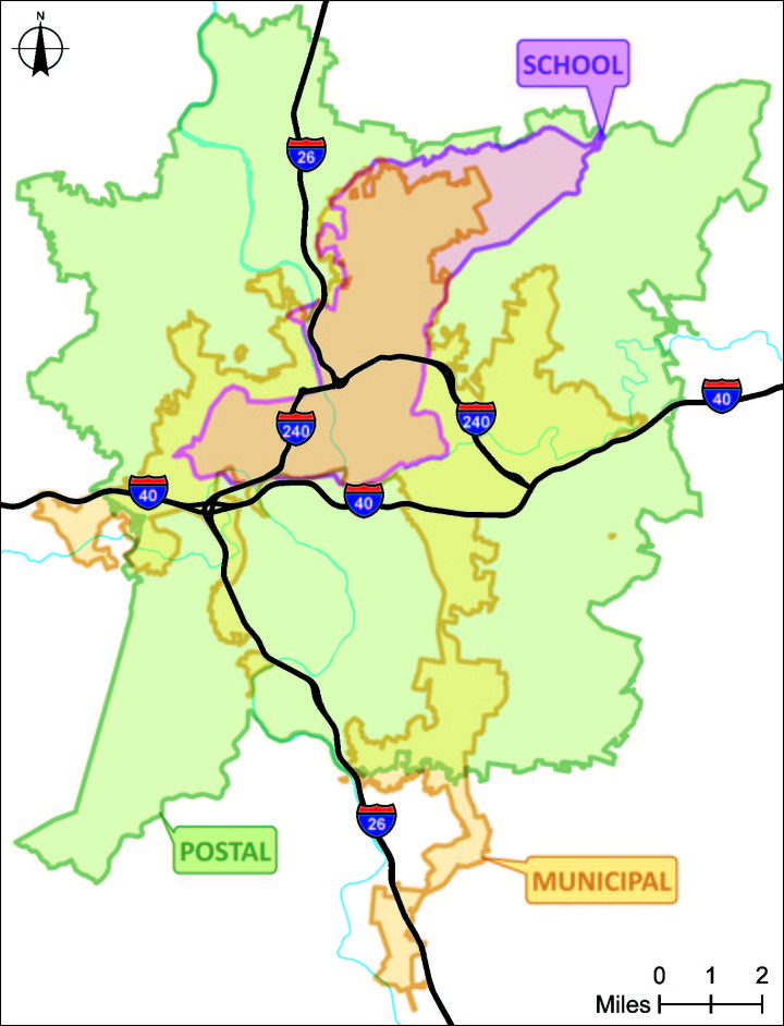
It doesn’t help that the official municipal boundary traces a shape like a psychedelically distorted question mark. Or that a crow could fly just 1 mile from City Hall’s roof and be outside the city limits (in Chunns Cove) but could fly a dozen miles from that same roof in another direction and still be under city jurisdiction (at the airport).
Years ago a local reverend told me, I think rightly, that many Buncombe County families understand the geographic extent of the school districts better than that of the municipalities. So does the “Asheville City” school district approximate the city limits? Not even close. In fact, more of Asheville falls outside the “city” school district than falls within it, and a good chunk of the school district lies outside the city’s boundaries.

I’ve surprised many a resident by pointing out that technically, Biltmore Estate is not in Asheville. Yet the company’s marketing materials use phrases like “located in Asheville.” And if I had a dollar for every time a Woodfin, Candler or Fairview housing development has touted its Asheville location in an ad, I could buy a house.
Maybe some of these companies should be forgiven because their location has an Asheville mailing address. And if the U.S. Postal Service says they’re in Asheville, how can you argue with that? Well, for every ZIP code, the postal service assigns a default city and asks that we use it “whenever possible.” Asheville is the default city for the ZIP codes immediately north, south, east and west of 28801, encompassing an area much larger than the city proper (see map).
So if you Google “Biltmore Forest Town Hall,” the search engine will serve up the USPS-preferred Asheville address. Do note, however, that this goes both ways: Some taxpaying residents of the city of Asheville are asked to use an Arden or Candler mailing address.
If that weren’t bad enough, road signs add to the confusion. For example, if you’re driving north on Interstate 26 “West” from Henderson County, once you’ve passed the airport and Biltmore Park (which are both in the city), you’ll see a sign saying Asheville is still 11 miles away. The next interchange you’ll encounter — in just 4 miles — is in the city, but the sign indicates the driving distance to downtown Asheville.
If you see a headline saying “City Jobless Rate Lowest in NC,” the odds are good that it’s actually talking about the Asheville Metropolitan Statistical Area, which includes all of Buncombe County, as well as Madison, Henderson and Haywood counties. But don’t mistake that label for yet another Census Bureau designation, the Asheville Urban Area, which is stitched together out of fragments of the same four counties, plus a tiny bit of Transylvania County.
And I won’t even try to begin to explain how the city’s fire protection area or zoning jurisdiction or water service district differ from the city limits, but they do.
I raise the question “Where is Asheville?” because this community will soon be asked to consider the question “Where is Asheville going?” As of this writing, City Council was poised to approve a contract to launch the big kahuna of city planning efforts: updating the comprehensive plan. In other words, creating a blueprint for how development will affect Asheville over the next 20 years.
But if it’s an official city of Asheville plan, what area should the blueprint cover? After all, burning issues such as housing choices, livability, equity, transportation, safety and character don’t stop at any administrative boundary. And while city ordinances may apply to only a limited area, the planners will have to think regionally in order to achieve credible policy solutions.
In other words, city staff and their consultants will have to cross borders and work with neighbors. No matter how well-crafted the eventual plan may be, arbitrary geographic limits will hinder its effectiveness.
The muddled lines described above serve some purpose within their respective parochial contexts, but when we’re looking at the big picture, let’s color outside the lines — well outside them.
Asheville resident Blake Esselstyn is the founder of the FrontWater consultancy.


If you call the police and Asheville PD shows up, you live in Asheville. The Sheriff? You don’t
Not necessarily an absolute, the emergency response agencies will, in most urgent scenarios, back each other up. So yes, Sheriff will take bulk of all non-municipal calls both those us on the edge could very well APD. Check your tax bill….that’s your true answer.
Asheville ended around 2013…
Actually, having been there when AVL was brought to national attention as the best place in the country to live, I can tell you that my asheville ended by 2006. It became , thanks to all the people who took the book title seriously, just another traffic-clogged, tourist-ridden, narrow street, dangerous to drive into on I-26, minus Bele Chere, mess . Those tall hotels funneling money out of the city were the next to last stake in the heart, the current tall hotel going up on a main walking street with the wind-tunnel characteristic soon to thrive, was the last stake. RIP, my AVL.
This makes things a lot more clear for me, thanks city slicker. We need these city planners/comp planners to definitely think outside Asheville’s spider shape. How is the county gettin’ in the loop?
After TODAY, 07/15/2020. EVERYONE in the greater Asheville area needs to pay CLOSE attention IF your taxes are being funneled to the CITY. WHY? Because the City Council VOTED to take YOUR tax dollars and use them to pay “slavery reparations”????