The National Weather Service warns of a “major winter storm, expected tonight through Saturday,” in effect from 7 p.m. this evening, Thursday, Jan. 21, through 7 a.m. on Sunday, Jan. 23.
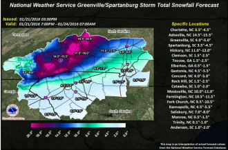


The National Weather Service warns of a “major winter storm, expected tonight through Saturday,” in effect from 7 p.m. this evening, Thursday, Jan. 21, through 7 a.m. on Sunday, Jan. 23.
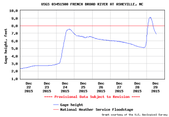
WNC was hit with heavy rainfall Monday and early Tuesday morning causing significant flooding, power outages, tornado warnings, road closures and even daring rescues of several Buncombe County residents threatened by rising waters. The rainfall most likely isn’t finished with us yet. According to the National Weather Service, an additional 1 to 2 inches of rainfall […]

The National Weather Service has issued a flood watch for 18 Western North Carolina counties, beginning Tuesday afternoon and lasting until Wednesday evening.
Cover your crops and bring your potted plants inside: It’s about to get chilly in Western North Carolina.
Last week’s heavy rainfall pushed E. coli levels in Asheville’s portion of the French Broad River past the Environmental Protection Agency’s safety threshold, posing a health threat to swimmers and tubers.
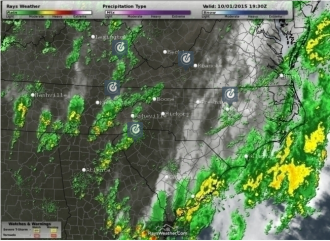
According to the National Weather Service, “Heavy rain will overspread the Western Carolinas and Northeast Georgia on Friday and continue off and on through the weekend as an upper low remains nearly stationary over the Southeast states and Hurricane Joaquin moves North near the Carolina Coast.”
According to the National Weather Service, “Rainfall rates … could be enough to produce flash flooding, especially in locations near the Blue Ridge escarpment that have seen heavy rainfall since last week.”

It may be drizzling today, but the unusual lack of rainfall has pushed the state into drought for the first time in more than two years, says the North Carolina Department of Environment and Natural Resources.
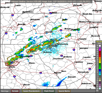
Twenty-six North Carolina counties are under a tornado watch today, Monday, April 20, expiring later this evening. The area is also due for some hazardous weather, with potential “severe thunderstorms” toward the evening hours.
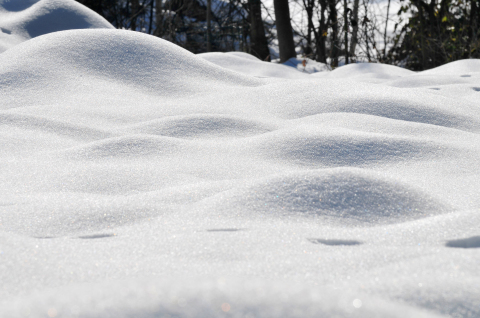
Don’t put away your coats just yet, Western North Carolina. The National Weather Service has once again issued a winter storm warning and a hazardous weather outlook for our region — predicting up to 5 inches of snow in Greater Asheville and up to 8 inches to our west and south.

As grey skies turned to snow, snow turned to sleet, and sleet turned to ice pellets clinking across the windows of Western Carolinians, residents across the region turned to social media to document the ice storm that left many Ashevilleans housebound this morning, Tuesday, Feb. 17.
A layer of ice began to build up on the streets by mid-day Monday, leaving both pedestrians and drivers skidding along the sidewalks and streets. Over night, about 1,200 North Ashevilleans experienced power flickers and outages after heavy ice damaged Duke Energy equipment.
With the early releases, store closures, warnings of severe winter weather and Twitter-users warning of #Snowmaggedon2015, Ashevilleans have been rushing to grocery stores all morning to stock up on bread, water — and apparently beer, according to a Twitter picture of emptying Ingle’s beer shelves.

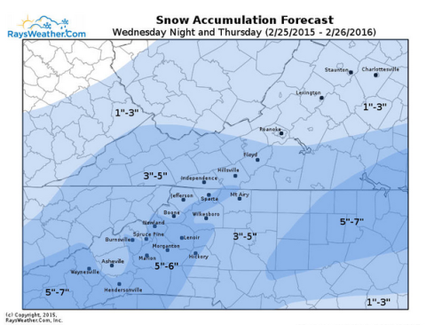
With Sunday’s recorded high in Asheville reaching 69 degrees, it seemed as if Nibbles the groundhog, professional local meteorologist, had correctly predicted an early spring. But by mid-week, we’ll falling back into our winter groove, with possible snow flurries Wednesday night into Thursday morning, and temperatures dropping as low as 5 degrees Saturday night.

The National Weather Service has issued a freezing rain advisory from 10 p.m. tonight to 10 a.m. tomorrow morning, Wednesday, Jan. 14.

The National Weather Service has issued a Hazardous Weather Outlook for multiple Western North Carolina counties Wednesday, Jan. 7, and Thursday, Jan. 8. “Wednesday, cold wave likely,” reads a passage from the NWS’s report. “An arctic airmass will settle Southward across the region starting Wednesday and persist into Friday. Temperatures will likely run 10 to […]
According to the National Weather Service, the higher elevations of Western North Carolina (especially near the Tennessee border) should expect an inch or two of snow accumulation overnight and into the morning. Residents in the valley areas may see some snow Wednesday morning, but are mainly advised to watch for slick, icy roads. “The combination […]
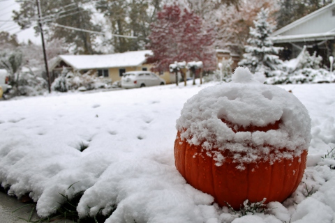
Just minutes after midnight on Halloween night, the rain turned to snow, blanketing Western North Carolina in a wintery scene in the midst of the fall season.
The National Weather Service has issued winter weather advisories and warnings for eleven Western North Carolina counties, effective from Friday, Oct. 31 at 8 p.m., to Saturday, Nov. 1, 8 p.m. Follow #avlsnomg for updates as conditions progress.

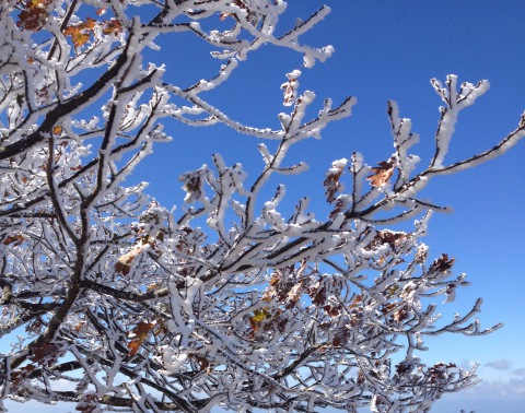
After a series of snow predictions that (literally) fell short of expectations this year, Western North Carolinians woke up to snow on March 6, 2013. These are the tweets, photos, video and more taken by folks at home, at work and out in the snow. This post will be updated throughout the day. (photo by Instagram user @Skippyhaha)
The National Weather Service has issued a winter weather advisory for a swath of the western part of the state, including Asheville, cautioning about snow showers today and “bitter wind chill” later tonight.
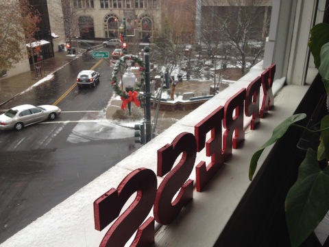
Twitter is abuzz with reports of increasingly icy conditions across Asheville and Western North Carolina, causing hazardous driving conditions and other problems.