
The National Weather Service warns of a “major winter storm, expected tonight through Saturday,” in effect from 7 p.m. this evening, Thursday, Jan. 21, through 7 a.m. on Sunday, Jan. 23.
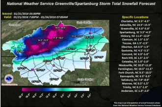


The National Weather Service warns of a “major winter storm, expected tonight through Saturday,” in effect from 7 p.m. this evening, Thursday, Jan. 21, through 7 a.m. on Sunday, Jan. 23.
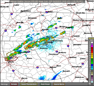
Twenty-six North Carolina counties are under a tornado watch today, Monday, April 20, expiring later this evening. The area is also due for some hazardous weather, with potential “severe thunderstorms” toward the evening hours.
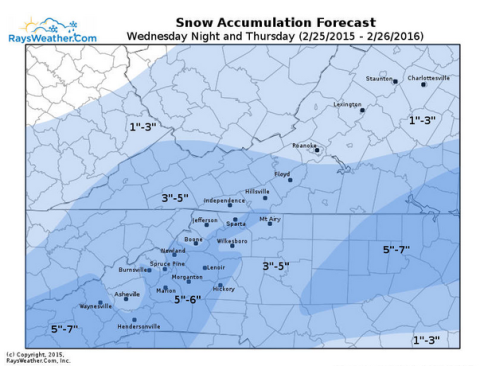
Don’t put away your coats just yet, Western North Carolina. The National Weather Service has once again issued a winter storm warning and a hazardous weather outlook for our region — predicting up to 5 inches of snow in Greater Asheville and up to 8 inches to our west and south.

As grey skies turned to snow, snow turned to sleet, and sleet turned to ice pellets clinking across the windows of Western Carolinians, residents across the region turned to social media to document the ice storm that left many Ashevilleans housebound this morning, Tuesday, Feb. 17.
A layer of ice began to build up on the streets by mid-day Monday, leaving both pedestrians and drivers skidding along the sidewalks and streets. Over night, about 1,200 North Ashevilleans experienced power flickers and outages after heavy ice damaged Duke Energy equipment.

The National Weather Service has issued a freezing rain advisory from 10 p.m. tonight to 10 a.m. tomorrow morning, Wednesday, Jan. 14.

The National Weather Service has issued a Hazardous Weather Outlook for multiple Western North Carolina counties Wednesday, Jan. 7, and Thursday, Jan. 8. “Wednesday, cold wave likely,” reads a passage from the NWS’s report. “An arctic airmass will settle Southward across the region starting Wednesday and persist into Friday. Temperatures will likely run 10 to […]

According to the National Weather Service, the higher elevations of Western North Carolina (especially near the Tennessee border) should expect an inch or two of snow accumulation overnight and into the morning. Residents in the valley areas may see some snow Wednesday morning, but are mainly advised to watch for slick, icy roads. “The combination […]
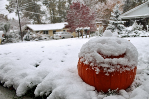
Just minutes after midnight on Halloween night, the rain turned to snow, blanketing Western North Carolina in a wintery scene in the midst of the fall season.