From the Institute for Climate Education at A-B Tech:
As we head into February, Western North Carolina continues to see plentiful rain as a steady stream of weather systems spread rainfall across the southern plains and into our area.
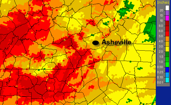
The image below shows the rainfall totals for January across the Southeast (the scale on the right is in inches.)

Asheville has seen its fair share of rain over the last several months. The monthly total for January at the AVL airport was 3.85”. That’s 0.18” above the average rainfall for January. And, we came into 2012 with some above average rainfall accumulations in November (1.67” above average) and December (1.52” above average).

With rain in the forecast for much of the weekend, it looks like we’ll keep adding to the totals in the near-term.
These images were generated using the National Weather Service’s radar and rain gauge data here. Much of the world’s weather data is gathered, archived and processed right here in downtown Asheville, at the National Climatic Data Center.
Want to learn more? Join us for one of the many classes offered by the Institute. You’ll find details here.


…and yet the drought persists and worsens. 40 miles south of us, it’s nothing but solid severe-to-exceptional drought all the way to the Gulf:
http://droughtmonitor.unl.edu/DM_southeast.htm
And that’s expected to continue or get worse for the foreseeable future:
http://www.cpc.ncep.noaa.gov/products/expert_assessment/seasonal_drought.html
If I had a few million dollars laying around, I’d try to buy a certain small municipal water system that sits on the edge of that drought, and which happens to sit at the end of a pipeline that leads directly to Asheville’s reservoir. Aw shucks, I’m too late:
http://www.tryondailybulletin.com/2012/01/19/tryon-considers-4-2m-offer-for-watersewer/