From the Institute for Climate Education at A-B Tech:
The beginning of this week started with significant rainfall over the region thanks to a large weather system that dumped a record amount of rainfall in Asheville on Tuesday, Sept. 18 (up to 6 inches in some parts of Western North Carolina), and provided more rain in two days than we usually expect during the entire month of September! Our area’s rivers and streams are doing their job of transporting that water downstream — but the evidence of all that moisture was still hanging around early this morning in the form of low clouds. I shot the image below earlier today as the clouds were beginning to break at 4,000 feet — revealing the early fall color that is starting to appear on ridgetops.

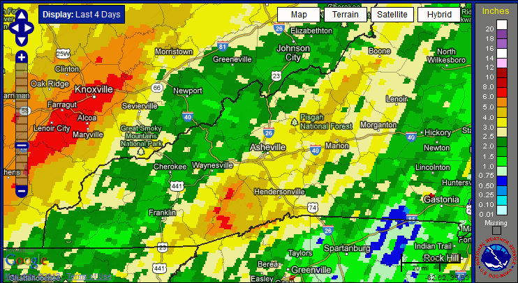
Locally, the heaviest rains during this week’s event fell southwest of Asheville in Transylvania, Jackson and Haywood Counties where some locations received over 6 inches of rain as indicated by the red colors in the image below. The picture shows the total estimated rainfall during the entire event so you can get a good look at how much rain our region received Monday and Tuesday. Note the large area in East Tennessee that saw over 6 inches of rain. The scale to the right of the image is in inches.

Image: NOAA’s National Weather Service, Southern Region Headquarters
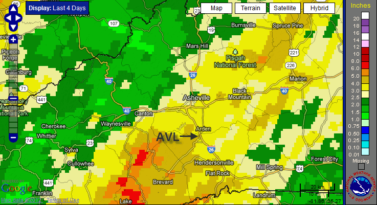
The Asheville Regional Airport (AVL) set a new daily maximum rainfall record of 3.28 inches on Tuesday, 9/18, shattering the old record of 1.72” set on that date in 1906. The image below shows how much rain the local area received during the two day event, including the 4.38 inches total that AVL received Monday and Tuesday. The normal rainfall for AVL during the entire month of September is 3.81 inches.

Image: NOAA’s National Weather Service, Southern Region Headquarters
We officially turn the corner from summer into fall this Saturday morning, Sept. 22, at 10:49 EDT. At that time, the autumnal equinox occurs, marking the transition into autumn for the Northern Hemisphere when the tilt of the Earth’s axis will mean that the Southern Hemisphere will now begin to receive more of the sun’s energy. (Mom always did say that it is was nice to share.) While the end of summer comes as good news to many folks who saw record high temperatures and extended drought over the summer, personally — I hate to see the long hours of daylight go. You may have already noticed that the sunrises are coming later and that sunset is coming earlier each evening … a sure sign that fall is about to begin.


Where was this picture taken? It looks like the Springs.
The picture was taken in Madison County looking north into Big Laurel