


From the Institute for Climate Education at A-B Tech: Were you part of the “haves” or the “have not-so-muchers” this week?
As you can see from the image below, the higher elevations of Madison County were definitely part of the haves with about 6 inches of fluffy snow over the weekend and another 6” of blowing blizzard-like snow Tuesday night and Wednesday.
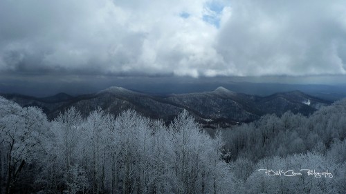
Once again, the Asheville Regional Airport missed out on measurable snowfall, recording just a trace each day in this past week’s snow events and leaving most folks in the lower elevations still hankering for a good old-fashioned snowfall. While some of us (ummm — me!) at the higher elevations are REALLY looking forward to spring.

Again, in Western North Carolina, it’s all about location … location … location.
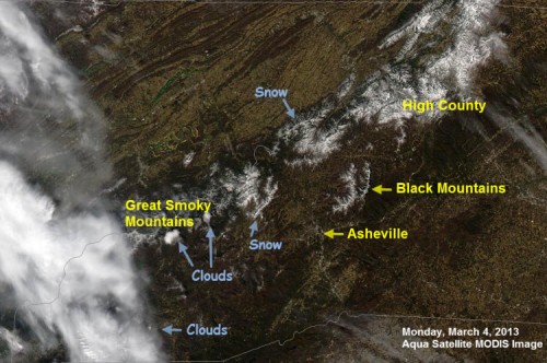
Image: Space Science and Engineering Center, University of Wisconsin-Madison with annotation by Pamela McCown
The satellite image above, taken on Monday, March 4, shows the snow that accumulated over the weekend and how it was isolated mainly to the higher elevations. The image below, taken around 2 p.m. Thursday afternoon, shows that the snow blanketing the region as a result of the most recent storm did cover more area. However, clouds still blocked much of the view, and most of the snow that fell in the lower elevations had already disappeared.
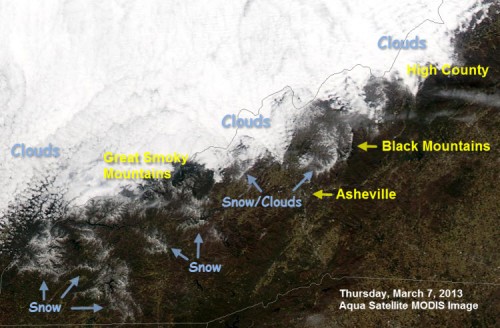
Image: Space Science and Engineering Center, University of Wisconsin-Madison with annotation by Pamela McCown
Both of the recent snow events were the result of conditions that meteorologists call northwest flow. This occurs when low-level winds and cold air approach the area from the northwest, and that cold air is pushed up the slopes of the mountains that form the ridge line along the North Carolina/Tennessee border. As the air is forced up the slopes, it cools and forms precipitation that falls in the form of snow on the mountain ridges along the border and in some of the higher elevations.
These conditions occur fairly often during the cold months and help to create micro-climates along the ridge lines that produce dramatically different weather than what is experienced in the lower elevations. It really is hard to overstate the difference in the winter weather that occurs on the mountain tops versus what happens in the valley.
What does it take to get a good amount of snow in Asheville and the lower elevations? The right kind of storm.
In order to get a significant snow in the valley, we need a large storm system that is timed exactly right with a strong cold front. Often times, we see these conditions develop when a large area of low pressure develops in the Gulf of Mexico during the cold months. Remember the big snow of December 2009, and the “Storm of the Century” in 1993? Those were both the result of low-pressure systems that developed in the Gulf and then moved across the Southeast and up the East Coast.
While it looks like we’re running out of time for a big snowfall this winter, don’t count us out just yet. Some of our biggest snowfall events have occurred in March, and even April.
Event Notice: SkyWarn 2013 is coming on Saturday, April 13th!
Do you want to learn more about severe weather? What causes it. How it forms. What you can do to protect yourself, your family, your co-workers? And, how to report it to the National Weather Service.
Join us for a free severe weather workshop on Saturday, April 13, at A-B Tech. The event is free and open to anyone who wants to attend, but pre-registration is required. You’ll find more information and super simple registration here.
I hope you’ll join us!

Before you comment
The comments section is here to provide a platform for civil dialogue on the issues we face together as a local community. Xpress is committed to offering this platform for all voices, but when the tone of the discussion gets nasty or strays off topic, we believe many people choose not to participate. Xpress editors are determined to moderate comments to ensure a constructive interchange is maintained. All comments judged not to be in keeping with the spirit of civil discourse will be removed and repeat violators will be banned. See here for our terms of service. Thank you for being part of this effort to promote respectful discussion.