Governor Pat McCrory has declared a state of emergency in all 100 North Carolina counties in preparation for predicted severe flooding.
According to the National Weather Service, “Heavy rain will overspread the Western Carolinas and Northeast Georgia on Friday and continue off and on through the weekend as an upper low remains nearly stationary over the Southeast states and Hurricane Joaquin moves North near the Carolina Coast.”
These two weather conditions “will produce several inches of rainfall,” which, after the last week of heavy rain, has once again driven the region to a flash flood watch — from Friday morning through Monday, Oct. 5.
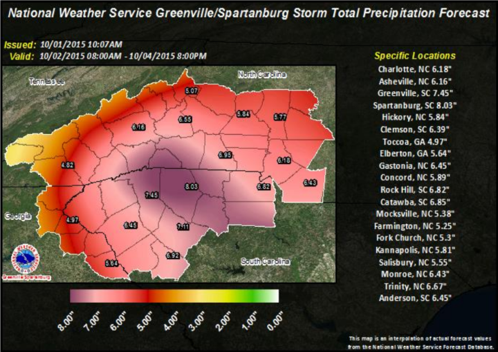
“Although some uncertainty remains as to the amount, there is growing confidence that a widespread five to 10-inch rainfall will occur, with a band of 10-15 inches possible across the Western Carolinas.” reads the NWS report. “This amount of rainfall could be historic and could result in significant, life-threatening flash-flooding.”
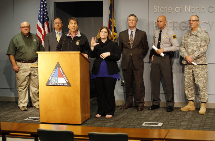
At a news conference at the North Carolina Emergency Operations Center, the governor said that weather systems, independent of Hurricane Joaquin, are likely to dump flooding rains on the state. Hurricane Joaquin will increase rainfall totals should it make landfall in North Carolina. Presently, the hurricane is predicted to brush the Outer Banks.
“We’re hoping for the best, but hope is not preparation nor is it a plan,” Governor McCrory said in a release. “I’ve ordered all state agencies to begin preparation for the severe weather, particularly flooding, that is going hit just about every corner of the state during the next few days.”
However, there is still “considerable uncertainty as to what degree the upper low and Joaquin will interact,” reads the NWS alert. “This will have a large impact on the amount of rain that falls across the area. Thus, storm total rainfall amounts are still very uncertain.”
The governor signed an executive order authorizing the state of emergency which will waive hour and weight restrictions for truck drivers responding to the storm. The waivers particularly help farmers and electric utility crews working to restore power.
Public Safety Secretary Frank L. Perry said officials are preparing for widespread flooding in areas across the state.
“Regardless of the impacts of Hurricane Joaquin, North Carolina has the potential for life-threatening flooding,” cautioned Perry in the governor’s release. “We want everyone to remember to ‘Turn around, don’t drown.’”
The NWS report adds, “Periods of very heavy rainfall are expected to produce flash flooding along smaller creeks and streams, with significant flash flooding possible, especially in areas that received heavy rain in recent days. Meanwhile, the prolonged period of heavy rain, combined with stream flows that are already above normal, could result in flooding along main stem rivers by early next week. People living near streams should monitor the situation closely over the next one to two days. Now is the time to decide what you will do if threatened by flood water.”
The NWS also warns that slope failures and landslides could occur “should the heavy rain develop as expected, with rainfall amount of five to 10 inches possible … between Friday and Sunday.
“Higher amounts of rainfall are possible near the Blue Ridge,” the alert continues, “where the most rain fell within the last week. Rainfall of five inches or more in similar storms has been associated with an increased risk of landslides and rockslides. … People living in areas prone to landslides should be aware of the danger and be prepared to act.”
Click here for a list of precautions for landslides.
Search and rescue teams as well as National Guard soldiers, Highway Patrol troopers and Department of Transportation crews are preparing for the weather, explains the release from the state.
“NCDOT crews are preparing for this storm and will remain on standby as we continue to monitor its track,” Transportation Secretary Nick Tennyson said. “We are ready to shift resources as necessary to address any impacts, and we urge travelers throughout the state to use extreme caution and avoid driving on flooded roadways.”
The governor asked citizens to update and replenish emergency kits with bottled water, non-perishable food, a weather radio, copies of important documents, flashlights, batteries and any supplies and medications for pets.
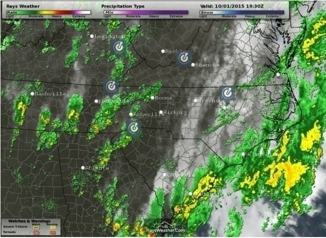
Meanwhile, local forecasters at Ray’s Weather warn: “One important note here: Regardless of the path of Joaquin (out to sea or hitting the East Coast), significant rainfall is expected locally. We probably won’t know the details of where Joaquin is going for another day or so. But several inches of rain is a good bet for much of the area between now and Sunday night. With wet conditions from the recent rains, serious and life-threatening flooding looks like a no-brainer. We hope to get this out of here by early next week.”


Before you comment
The comments section is here to provide a platform for civil dialogue on the issues we face together as a local community. Xpress is committed to offering this platform for all voices, but when the tone of the discussion gets nasty or strays off topic, we believe many people choose not to participate. Xpress editors are determined to moderate comments to ensure a constructive interchange is maintained. All comments judged not to be in keeping with the spirit of civil discourse will be removed and repeat violators will be banned. See here for our terms of service. Thank you for being part of this effort to promote respectful discussion.