After more than two decades of discussion and debate, the North Carolina Department of Transportation is getting the ball rolling on the Interstate 26 connector project. And though actual construction is still years away, the next few weeks are the public’s best chance to influence the route of a massive infrastructure project that, regardless of which option is chosen, will cost hundreds of millions of dollars, displace dozens of homes and businesses, and change the face of Asheville.
Concerned residents have until Wednesday, Dec. 16, to submit their comments to the DOT by phone, mail, email or online (see box, “Weighing In”). The state agency will take that feedback into account in selecting its preferred design, a decision due next spring.
In its current form, I-26 takes a sharp turn as it merges onto Interstate 240 at Patton Avenue, breaking up the interstate and requiring drivers headed north to cross four lanes of often bumper-to-bumper traffic to access “future I-26” via a winding ramp. For the next 16 miles, the roadway is not yet up to current interstate standards — but that’s another project altogether.
Just get it done
The connector project, long a source of heated controversy, picked up speed last year when an informal group of Asheville City Council members and Buncombe County commissioners began pushing the DOT to improve the road, citing safety concerns and economic benefits. And on Nov. 16, the state agency hosted an open house and public hearing on nine proposed routes covering three distinct sections. Hundreds of residents filled the Renaissance Hotel’s Grand Ballroom to study and have their say about the various traffic patterns displayed on giant maps.
Consensus, however, seemed to be in short supply. During public comment, some residents urged the DOT to simply choose the best alternative and do it. Other speakers criticized the agency for coming up with designs better suited to a metropolis like Atlanta or Charlotte than to Asheville. Some people spoke on behalf of plan 4B; others dismissed it as overly complicated. Many argued that the future lies in self-driving cars and multimodal transportation — including not just bikes and buses but also commuter trains. Still others disputed the traffic projections that were the basis for these designs, saying the current traffic volume is actually much lower than what the 2005 study predicted.
Asked about that last point, DOT Construction Engineer Ricky Tipton said a new traffic-demand model has been released. “That will be looked at again prior to finalizing the section, and if it showed something different, other options might be looked at.”
But one thing most people seemed to agree on at the hearing was that this particular section of roadway desperately needs some sort of fix. Madison County Commissioner Matthew Wechtel said commuters to Asheville from his county must contend with “malfunction junction.”
Even though the DOT is asking for input, however, for ordinary mortals, comparing these complex plans isn’t easy. To further complicate matters, the connector project is broken up into three separate subprojects, labeled sections A, B and C. To help you get a handle on what’s being proposed, here’s a look at the key differences among the alternatives. It might also be useful to trace the routes you actually drive on the various maps to see how those differences would most affect you.
First things first
Section B, the northernmost stretch, is the part that does the actual connecting. It spans downtown and West Asheville from just north of the Haywood Road exit to Patton Avenue, crossing the French Broad River and continuing on to future I-26 in North Asheville. The DOT is considering four alternatives for Section B, each of which takes a different approach to bridging the river. Two of those options bypass the Burton Street community, a historically African-American neighborhood that was heavily impacted when I-240 was built, displacing many residents and leaving bitter memories that have resurfaced repeatedly in the debate over the I-26 connector. The other two alternatives would run right through the neighborhood.
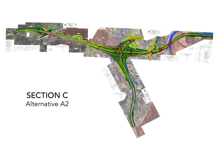
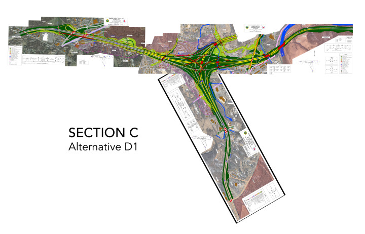
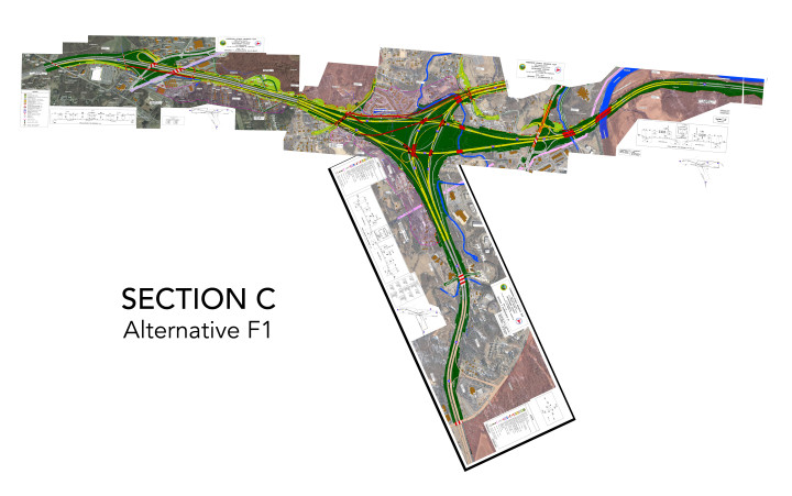
At the southern end of the project, Section C covers the I-26/I-40 junction in southwest Asheville, near Enka-Candler. There are also four alternatives for this part, differing mostly in which style of interchange ramp they use.
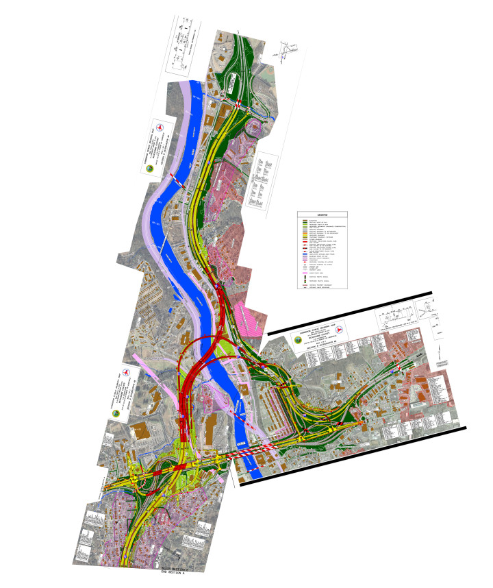
In the middle sits Section A, which was something of a flash point during the public hearing, since the DOT is proposing only one plan: an eight-lane highway through West Asheville that would double the current roadway’s width and take out 102 buildings in its path.
This will be the last part of the project to get built, however, and meanwhile, none of the nine designs is absolute, DOT Public Involvement Officer Drew Joyner explained at the hearing.
So for both residents and the DOT, the immediate challenge is determining the general route through sections B and C.
Deconstructing Section B
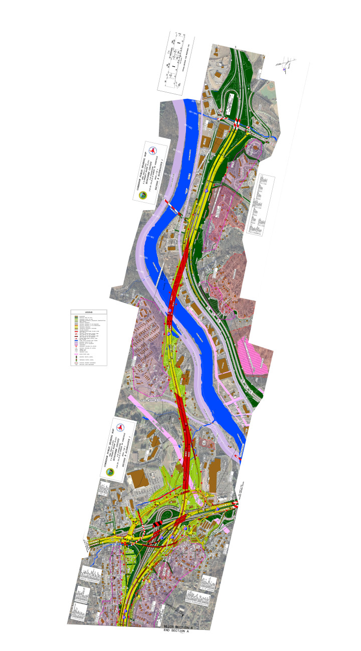
The four options for this section are 3, 3C, 4 and 4B. Alternative 3 dives under Patton Avenue before cutting between Westgate Shopping Plaza and the Sam’s Club parking lot. It then rises over Emma Road before coming back down to the east of the Woodridge Apartments and crossing the river. The bridge passes over Zen Tubing and Riverside Drive before joining back up with a widened version of the future I-26 west of Montford.
At the hearing and in Facebook group discussions before the event, however, this option drew criticism for two main reasons. The first was the difficulty of accessing Haywood Road from the north: Traffic would exit I-26 before Patton Avenue and hit four lights before running through the Burton Street neighborhood on its way to the existing Haywood Road exit. Critics also disliked the roundabout way traffic coming from the south would be routed to Westgate Plaza.
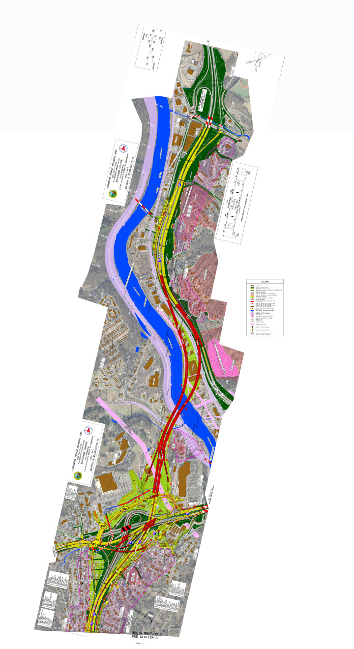
Alternative 3C continues in much the same way, except that it crosses the French Broad much sooner, turning right behind Westgate Plaza before splitting up and crossing the river on two separate bridges. The westbound (technically northbound) lane crosses over the vacant warehouse at 472 Riverside Drive before merging into a widened version of the future I-26 behind Montford. The eastbound (read: southbound) lane passes over this building as well but then veers north, proceeding through what’s now the Asheville Hardwood Center, O’Reilly Auto Parts and Total Performance Muffler and Brakes — all of which the DOT would have to acquire prior to construction.
Alternatives 4 and 4B call for a looping design to separate both I-26 and I-240 traffic from local Patton Avenue traffic. Unlike plans 3 and 3C, 4 and 4B pull interstate traffic off the Jeff Bowen Bridge. Both plans show I-26 dipping under Patton Avenue, but from there, they go separate ways.
The differences between the two involve both how they cross the river and how many ramps and bridges they envision to accommodate the exchange of vehicles between the two highways and local roads.
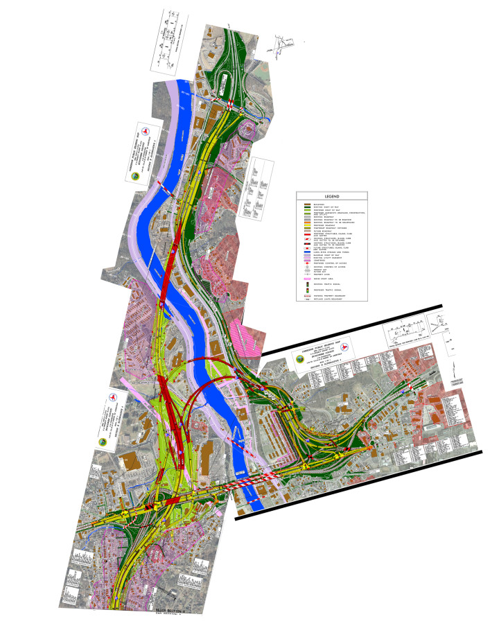
Alternative 4 calls for layered ramps behind Westgate Plaza and over Emma Road, with a bridged entrance ramp that splits in two to lead traffic both north to I-26 westbound and over the river to I-240 east. Across the river, the I-240 on-ramp merges with another bridged ramp, bringing in the local traffic from I-26 and crossing over Asheville Auto Parts and Salvage on Riverside Drive. There’s yet another bridge over the river where I-240 ends as it crosses over I-26 and then splits into an on-ramp for I-26 east and an off-ramp to Patton Avenue. I-26 then follows the same path seen in Alternative 3, crossing the river north of the Woodridge Apartments.
Alternative 4B emphasizes compactness and sensitivity to the needs of local drivers. While the other three alternatives provide limited access to Haywood Road from the north, exiting the interstate behind Westgate before stopping at a light on Patton, 4B keeps the off-ramps short and tight to the highway. This allows for interstate access to Haywood Road and, like Alternative 4, keeps interstate traffic off the Jeff Bowen Bridge.
Another big difference is that, just as I-26 follows a similar path in options 3 and 4, 4B routes I-26 similarly to Alternative 3C — albeit with the two lanes of traffic merged into a single bridge over the vacant warehouses on Riverside Drive.
High-impact changes
“We need a road to Asheville — not through Asheville,” argues Alan McGuinn, an architect at ARCA Design. McGuinn serves on the board of the Asheville Design Center, which helped develop 4B.
The idea, he explains, was to improve the road while remaining “sensitive to urban design. It needs to be a little slower and a little tighter, because we’re constrained by the mountains and the river — and we’re trying not to let roads take us over. … You don’t design an urban road like you’re out in open, rural country” — especially in a city like Asheville that’s already strapped for buildable land.
The other three Section B plans, he maintains, don’t fit Asheville’s need for both a minimal impact highway and a quick and easy way to get from place to place. Although 3 and 3C seem to make the most obvious connections — a straight shot over the French Broad for the through traffic on I-26 — both designs fail to take 240 traffic off the Jeff Bowen Bridge, the most traveled stretch of road in the whole region. And since a lot of those vehicles are trucks, this segment is reaching a critical point in terms of safety.
Both 4 and 4B also spare the Burton Street community, but they also require more right of way acquisitions on the other side of the river.
As things now stand, Alternative 3 would require relocating 34 residences, 24 businesses and two nonprofits; 3C would take 23 residences, 33 businesses and one nonprofit. Alternative 4 would take out 46 residences, 24 businesses, two nonprofits and one church. And finally, 4B would eliminate 33 residences, 34 businesses, one nonprofit and one church.
McGuinn, however, says the DOT changed the 4B design in ways that dramatically increased the number of residents and businesses displaced.
The initial version, he explains, called for relocating only three residences rather than the current 33. But the DOT, says McGuinn, changed the radius of one of the on-ramps in the Hillcrest area to cut into an adjacent neighborhood. “If you changed the radius [back] you could get rid of those [additional displacements].”
Since last year, he continues, “They’ve made so many changes that have improved 3C, while they’ve actually made 4 and 4B less workable. The question in my mind is: Why did it change from May 2014? It seemed to be fine.”
Asked about the changes, Tipton said: “They came up with a concept design and said, ‘Let’s make it work like this.’ It was explored further by city- and county-funded consultants at engineering firms, and they worked with the department to see what would make that concept work. And that resulted in 4B. We’re trying to keep it as small as possible, but when you get in there, you need the necessary things to make it safe.”
As always, of course, there’s also the question of money. At $332 million, 4B would cost the DOT over $100 million more than 3C, the cheapest option on the table at an estimated $230 million.
“But it’s not about what’s cheapest,” argues McGuinn. “It’s about the best value.” In 10 years after completion, he maintains, option 3C would reduce Patton Avenue traffic by just 11 percent. “Sure, it’s cheaper: It’s not doing as much.”
Meanwhile, he continues, the difference between the cheapest and most expensive Section C options amounts to almost $100 million. “I think we’d be better served to use it on Section B. Once they do Section B, it’s going to be very hard to fix later. If you put that extra money into Section B, that would pay for difference” between the 3C and 4B options.
Back to the drawing board?
Each alternative has its pros and cons, Tipton told Xpress. And currently, “There’s not a preferred alternative. Even if I told you my personal preference, it wouldn’t really mean anything. The point of [the hearing] is to gather public input to help us make the best decision.”
But as resident after resident stepped up at the public hearing to voice their opinions, it was clear that for many speakers, none of the proposals on the table was acceptable.
Newly elected City Council member Julie Mayfield, who is co-director of the environmental nonprofit MountainTrue, called on the DOT to follow the lead of Duke Energy, which recently decided to retool its plans in response to massive public outcry.
“I never imagined I would cite Duke Energy as an example,” said Mayfield, drawing laughs from the crowd. But the utility, she continued, listened to Asheville, “And if the largest energy company in the nation can provide a plan that meets public demands, then so can you.”
Tipton, meanwhile, stresses that all the current options are really works in progress, “more along the lines of ‘Is this the direction we want to go?’ You start with what we call the best fit alignment with the least amount of damage and disruption. And if the new traffic projections ever show that something smaller would work, then we would consider that, of course.”
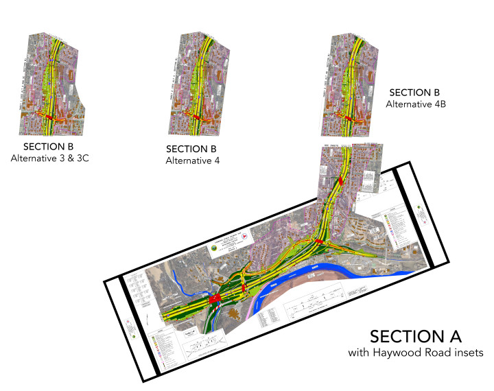
According to the DOT’s timeline, the agency will select the preferred alternative by next spring. Soon after, it will begin finalizing a plan that would be presented at a 2017 public hearing. Acquisition of the homes and businesses in the right of way (shown in green on the maps) would take place in 2019 for Section C and in 2021 for Section B; construction on B and C would begin in 2021 and 2024, respectively. Progress on Section A would start sometime after that.
All this may seem a long way off, but the DOT needs to know which concept to work from as it finalizes its plans. And with residents still sharply divided over how best to proceed, the feedback the agency receives in the coming weeks could significantly influence the outcome.
“Going forward, we’re going to look at selecting a recommended alternative next year and complete the final environmental impact statement,” notes Joyner. “We’ll follow that with another public hearing. So there’ll be another opportunity to speak, and there may be even more small group meetings, neighborhood meetings and maybe other opportunities as well. … And remember that written comments are weighed the same as verbal comments. They count the same. So if you didn’t get to say everything you needed to say [at the public hearing], then by all means, send us your comments.”
Weighing in
You have until Wednesday, Dec. 16, to make your voice heard. Comments can be recorded over the phone by calling 800-233-6315; mailed to Drew Joyner at 1598 Mail Service Center, Raleigh, NC 27699; emailed to djoyner@ncdot.gov or submitted online at engagencdot.mysidewalk.com.



Good, detailed article. Kudos.